
Hide
--- TEST SYSTEM --- TEST SYSTEM --- TEST SYSTEM ---
Hide
Sutton St. Edmund
hide
Hide
hide
Hide
hide


Hide
Hide
Hide
- The Library at Holbeach may prove useful in your research.
- Some Sutton St. Edmund parish records can be found at the Spalding Library.
Evelyn SIMAK has a photograph of St. Edmund's churchyard on Geo-graph, taken in January, 2011.
Adrian S. PYE also has a phtograph of Gravestones in Sutton St. Edmund's churchyard on Geo-graph, taken in January, 2011.
- The parish was part of the Long Sutton sub-district of the Holbeach Registration District.
- In an 1890 re-organization, Sutton St. Edmund became a part of the Gedney Hill sub-district within the Holbeach Registration District.
- Check our Census Resource page for county-wide resources.
- The table below gives census piece numbers, where known:
| Census Year | Piece No. |
|---|---|
| 1841 | H.O. 107 / 611 |
| 1851 | H.O. 107 / 2097 |
| 1861 | R.G. 9 / 2326 |
| 1871 | R.G. 10 / 3327 |
| 1891 | R.G. 12 / 2566 |
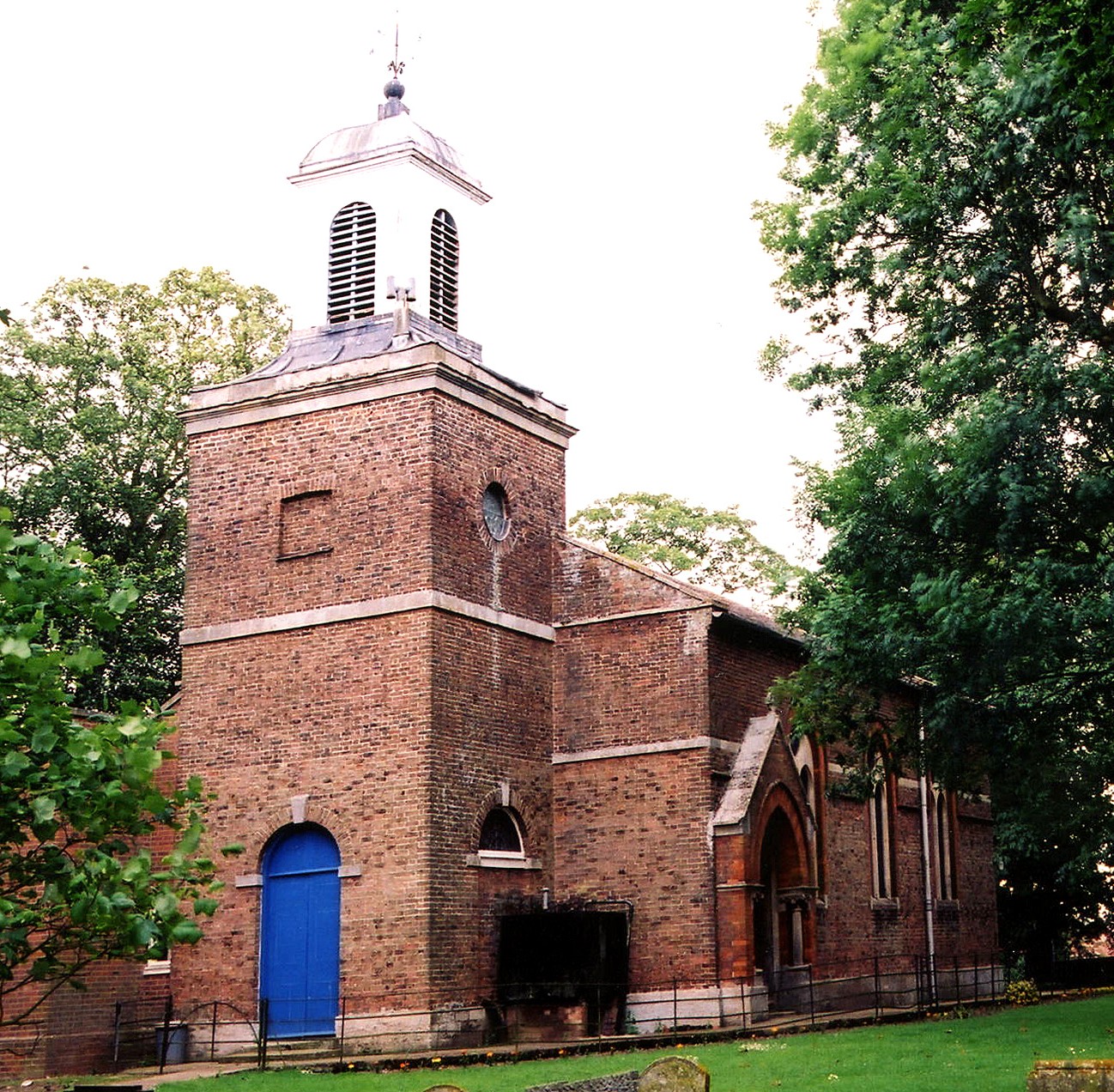
- The church is dedicated to Saint Edmund (hence the parish name).
- The church was rebuilt in 1798.
- Sutton St. Edmund used to be a chapelry of Long Sutton before being formed into its own parish.
- There is a bridge over the stream on the southeast corner of the parish, which takes one into Cambridgeshire. Harold's Bridge had a small Methodist chapel on the Cambridge side. (JB)
- Here is a photo of St. Edmund's Church, taken by Ron Cole (who retains the copyright):
- Parish registers exist from 1706 (some sources give 1700). Bishop's transcripts go back to 1561.
- Sutton St. Edmund is in the East Elloe Deanery.
- The Baptists and the Free Methodists had chapels here in the 1800's. For information and assistance in researching these chapels, see our non-conformist religions page.
- Check our Church Records page for county-wide resources.
- The parish was part of the Long Sutton sub-district of the Holbeach Registration District.
- In 1891, Sutton St. Edmund became a part of the Gedney Hill sub-district within the Holbeach Registration District.
- Check our Civil Registration page for sources and background on Civil Registration which started in July, 1837.
Sutton St. Edmund is a parish and a village about 100 miles north of London, 14 miles southeast from Spalding and 5 miles west of the A1101 trunk road that runs between Wisbech and Long Sutton. Gedney Hill parish lies to the west, separated by a cut of the South Holland Main Drain. Cambridgeshire to the south and east, also defined by a drainage cut. The area is typical fenland: marshy and flat, drained by several small canals and the larger South Holland Main Drain.
If you are planning a visit:
- By automobile, consider taking the B1166 arterial road west out of Wisbech. It will take you across the south end of the parish.
- There is caravan parking and camping just south of the village, near the B1166 road.
- Adrian S. PYE has a photograph of the Village Sign on Geo-graph, taken in January, 2011.
- J. HANNAN-BRIGGS has a photograph of a different Village Sign on Geo-graph, taken in July, 2013. Rather ordinary, eh?
- See our touring page for visitor services.
- Ask for a calculation of the distance from Sutton St. Edmund to another place.
- See our Maps page for additional resources.
You can see maps centred on OS grid reference TF369133 (Lat/Lon: 52.70047, 0.024633), Sutton St. Edmund which are provided by:
- OpenStreetMap
- Google Maps
- StreetMap (Current Ordnance Survey maps)
- Bing (was Multimap)
- Old Maps Online
- National Library of Scotland (Old Ordnance Survey maps)
- Vision of Britain (Click "Historical units & statistics" for administrative areas.)
- English Jurisdictions in 1851 (Unfortunately the LDS have removed the facility to enable us to specify a starting location, you will need to search yourself on their map.)
- Magic (Geographic information) (Click + on map if it doesn't show)
- GeoHack (Links to on-line maps and location specific services.)
- All places within the same township/parish shown on an Openstreetmap map.
- Nearby townships/parishes shown on an Openstreetmap map.
- Nearby places shown on an Openstreetmap map.
- In the middle of the village is a granite cross, erected to memorialize the men of the parish who perished in World War I.
- J. THOMAS has a photograph of the War Memorial on Geo-graph, taken in June, 2015.
- For World War I and World War II, see the Roll of Honour site for a list of those who served.
- One lad lost in World War One was George FLOWERS. He and all his crewmates were lost when the HMS Good Hope was sunk at the Battle of Coronel on 1 Nov. 1914.
- The name Sutton St. Edmund is from the Old English suth+tun, or "southern village", with the church name attached.
[A. D. Mills, "A Dictionary of English Place-Names," Oxford University Press, 1991]
- This parish was formed from Long Sutton civil parish in December, 1866. Prior to that, the area had been a chapelry of Long Sutton.
- The parish was in the ancient Elloe Wapentake in the South Holland district in the parts of Holland.
- For local parish governance, visit the Sutton St Edmund Parish Council site. Be aware, they are NOT staffed to answer family history questions.
- For today's district governance, visit the South Holland District Council site.
- In March, 1884. the Hospital Drove portion of this Civil Parish was transfered to Sutton St. Mary Civil Parish.
- In April, 1934. this Civil Parish gained 82 acres from Parson Drove Civil Parish in Cambridgeshire.
- Bastardy cases would be heard in the Elloe (Spalding) petty session hearings.
- After the Poor Law Amendment Act reform in 1834, the parish became part of the Holbeach Poor Law Union.
- There was a school here, rebuilt in 1856 and enlarged in 1871. In the 1870's it had about 55 students.
- Sutton St. Edmund's School was built in 1896 to hold 100 students. It was initially simply called "The Board School".
- Southeau School was built in 1898 to hold 70 students.
- For more on researching school records, see our Schools Research page.
Note: Sections marked (JB) were contributed by John R. G. Bland of Lincolnshire.