
Hide
--- TEST SYSTEM --- TEST SYSTEM --- TEST SYSTEM ---
Hide
Stewton
hide
Hide
hide
Hide
hide


Hide
Hide
“STEWTON, a parish in the Wold division of Louth-Eske hundred, parts of Lindsey, county Lincoln, 2½ miles S.E. of Louth, its post town. The village, which is considerable, is situated near the East Lincolnshire railway, which passes through the parish. There are brick, tile, and drain works. The soil consists of loam and clay, with a subsoil of clay. The living is a rectory* in the diocese of Lincoln, value £131. The church is dedicated to St. Andrew. The register dates from 1711."
”
from The National Gazetteer of Great Britain and Ireland - 1868
Hide
The nearby Library at Louth will prove useful in your research.
- The Lych Gate was built in 1903.
- Chris ? has a photograph of the Lych Gate at St. Andrew's Church on Geo-graph, taken in December, 2012.
- Steven FAREHAM has a photograph of an Open Lych Gate on Geo-graph, taken in October, 2015.
- Michael GARLICK has a photograph of the Churchyard on Geo-graph, taken in September, 2016.
- The parish was in the Louth sub-district of the Louth Registration District.
- Check our Census Resource page for county-wide resources.
- The table below gives census piece numbers, where known:
| Census Year | Piece No. |
|---|---|
| 1851 | H.O. 107 / 2111 |
| 1861 | R.G. 9 / 2383 |
| 1871 | R.G. 10 / 3404 |
| 1881 | R.G. 11 / 3263 |
| 1891 | R.G. 12 / 2608 |
| 1901 | R.G. 13 / 3084 |
| Stewton, Methodist (United Free) |
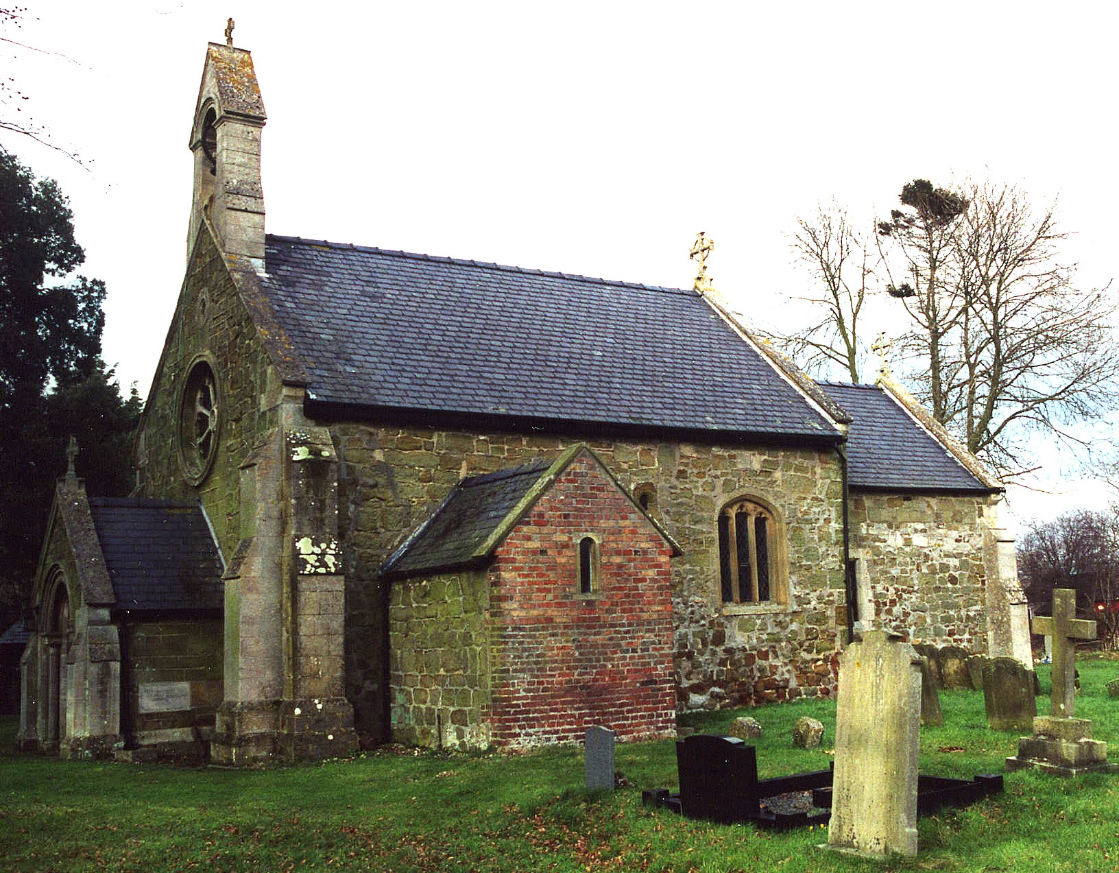
- The Anglican parish church is dedicated to Saint Andrew.
- The church is of Saxon and Early Norman origin.
- The church was built in the 11th century.
- The church was rebuilt in 1866.
- The church seats about 60.
- Jonathan THACKER has a view down Church Lane on Geo-graph, taken in June, 2011,
- There is a photograph of St. Andrew's church on the Wendy PARKINSON Church Photos web site.
- Here is a photo of St. Andrew's Church, taken by Ron COLE (who retains the copyright):
- The Anglican parish register dates from 1711 for baptisms and burials, and from 1756 for marriages.
- The Lincolnshire FHS has published several marriage indexes for the Louthesk Deanery to make your search easier.
- A United Methodist chapel was built here in 1861.
- Alex McGREGOR has a photograph of the former Methodist Chapel on Geo-graph, taken in August, 2014.
- For information and assistance in researching these chapels, see our non-conformist religions page.
- Check our Church Records page for county-wide resources.
- The parish was in the Louth sub-district of the Louth Registration District.
- Check our Civil Registration page for sources and background on Civil Registration which began in July, 1837.
Stewton is a village and a parish about 2 miles east of Louth in the Lincolnshire Wolds. The parish covers about 1,000 acres.
If you are planning a visit:
- Take the B1200 road east out of Louth and turn left after Bracken Hill. Or, alternatively, take Stewton Lane east out of Louth.
- See our touring page for more sources.
The National Gazetteer of Great Britain and Ireland - 1868
- Ask for a calculation of the distance from Stewton to another place.
- It is believed that there is a "disused Medieval Village" (DMV) just north of the existing hamlet of Stewton.
- Chris ? has a photograph of an old Hangar at the old airstrip on Geo-graph, taken in December, 2012.
- See our Maps page for additional resources.
You can see maps centred on OS grid reference TF362870 (Lat/Lon: 53.362282, 0.044804), Stewton which are provided by:
- OpenStreetMap
- Google Maps
- StreetMap (Current Ordnance Survey maps)
- Bing (was Multimap)
- Old Maps Online
- National Library of Scotland (Old Ordnance Survey maps)
- Vision of Britain (Click "Historical units & statistics" for administrative areas.)
- English Jurisdictions in 1851 (Unfortunately the LDS have removed the facility to enable us to specify a starting location, you will need to search yourself on their map.)
- Magic (Geographic information) (Click + on map if it doesn't show)
- GeoHack (Links to on-line maps and location specific services.)
- All places within the same township/parish shown on an Openstreetmap map.
- Nearby townships/parishes shown on an Openstreetmap map.
- Nearby places shown on an Openstreetmap map.
- This place was an ancient parish in Lincoln county and became a modern Civil Parish when those were established.
- The parish was in the Wold Division of the ancient Louth Eske Wapentake in the East Lindsey district of the parts of Lindsey.
- The parish is small enough to get by with just a Parish Meeting to deal with civil or political issues, and they do not have a formal Parish Council.
- For today's district governance, see the East Lindsey District Council.
- Bastardy cases would be heard in the Louth Eske petty session court every other Wednesday.
- As a result of the 1834 Poor Law Amendment Act reforms, the parish became part of the Louth Poorlaw Union.
- The children of this parish attended school at Grimoldby parish.
- For more on researching school records, see our Schools Research page.