Hide
--- TEST SYSTEM --- TEST SYSTEM --- TEST SYSTEM ---
Hide
South Ferriby
hide
Hide
hide
Hide
hide
Hide
Hide
hide
Hide
“SOUTH FERRIBY, a parish in the wapentake of North Yarborough, parts of Lindsey, county Lincoln, 3 miles W. of Barton-on-Humber, its post town, and 8 N. of Glanford-Brigg. It is situated on the S. bank of the river Humber, opposite North Ferriby, and includes the hamlet of Ferriby Sluice. Limestone is obtained and bricks are made. There is a mill for bone crushing. The living is a rectory in the diocese of Lincoln, value £192, in the patronage of the bishop. The church is a neat edifice, dedicated to St. Nicholas. Both the Wesleyans and Primitive Methodists have places of worship here, and there is a National school. Ferriby Hall is the principal residence.
”
from The National Gazetteer of Great Britain and Ireland - 1868
Hide
- The parish built a "reading room" here in 1884.
- The Mobile Library unit visits the village each Wednesday morning with a stop at the Village Hall.
- The nearby Barton-on-Humber Library is an excellent resource with a Local History section and a Family History section.
Pauline HEATHERSHAW, "South Ferriby - A 4000 year old Odyssey". It gives details of the parish history and the school headmasters through the ages.
- The parish was in the Barton sub-district of the Glanford Brigg Registration District.
- Check our Census Resource page for county-wide resources.
- The table below gives census piece numbers, where known:
Census
YearPiece No. 1841 H.O. 107 / 633 1851 H.O. 107 / 2118 1861 R.G. 9 / 2404 1871 R.G. 10 / 3438 1891 R.G. 12 / 2629
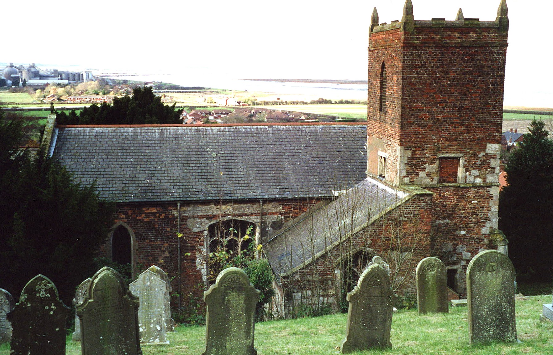
- A church was recorded here in the Domesday Survey of 1066.
- Ecclesiastical records indicate that South Ferriby and North Ferriby were once a single church parish.
- The Anglican parish church, built in the 13th Century, was dedicated to Saint Nicholas.
- The church was restored in 1889.
- In Kelly's 1900 Directory it is described as "the mutilated remnant of a much larger church."
- A church institute was built here in 1910.
- The church seats 200.
- There is a photograph of St. Nicholas Church on the Wendy PARKINSON Church Photos web site, taken by Paul Fenwick.
- Here is a photo of St. Nicholas church, taken by Ron COLE (who retains the copyright).
- Parish register entries exist from 1538.
- We have the beginning of a Parish Register Extract as a text file for your use. Your additions and corrections are welcomed.
- The Lincolnshire FHS has published several marriage indexes and a burial index for the Yarborough Deanery to make your search easier.
- There were chapels here prior to 1871 for Wesleyan Methodists and Primitive Methodists. For information and assistance in researching these chapels, see our non-conformist religions page.
- Check our Church Records page for county-wide resources.
- The parish was in the Barton sub-district of the Glanford Brigg Registration District.
- Check our Civil Registration page for sources and background on Civil Registration which began in July, 1837.
South Ferriby is a village and a parish in the far north of Lincolnshire, on the south bank of the River Humber. North Ferriby is in Yorkshire on the other side of the river. Horkstow parish lies to the south. The parish covers almost 1,600 acres. Ferriby Sluice is a hamlet in this parish, about one mile west of South Ferriby. Read's Island sits in the River Humber, just off shore, where the Weir Dike empties into the River Humber. The River Humber here is about 4 miles wide.
If you are planning a visit:
- Feririby Sluice lies just across the River Ancholm. David BROWN has a photograph of the South Ferriby Marina on Geo-graph, taken in September, 2019.
- Pick up a copy of "Guide and handbook to Winteringham and district" by Charles Edwin TRIMMER, ISBN B0000-EF3E0, publ. Jackson & Sons.
- Gerald ENGLAND has a photograph of Read's Island on Geo-graph, taken in 1981. The island lies in the Humber River just northwest of South Ferriby and north east of Winteringham. As you can see, the island is quite flat and often inundated by tidal surges.
- By automobile, take the A15 motorway north from Barnetby le Wold and turn left (west) at the A1077 trunk road. South Ferriby village is on the A155 west of Revesby and east of Tumby.
- See our touring page for more sources.
The National Gazetteer of Great Britain and Ireland - 1868
- Ask for a calculation of the distance from South Ferriby to another place.
- The parish was a well-known source of chalk, stone, tile and bricks for several centuries.
- The parish had a daily steam packet to Hull from the Sluice, except for Thursdays and Sundays. The boat was run by the Hull & Goole Steam Packet Company.
- A Temperance Hall, made of brick, was built here in 1882.
- The "Ferry Boat" Inn was here in Ferriby Sluice in 1842 run by Wm. ROWBOTTOM, but appears to have closed by 1868.
- The "Sloop Inn" functioned here in 1868 and 1872 run by Eli COLE and in 1882, run by Thomas SUMPTER, but appears to have closed by 1913.
- The Hope and Anchor Public House on The Sluice is part of the parish history. Now run as a restaurant and bar, it is still in operation. Reserve a table at their website. Individuals' names associated with the establishement in different years are:
| Year | Proprietors |
|---|---|
| 1842 | John ALTOFT, vict. |
| 1868 | George HOLMES |
| 1872 | Robert SMITH, vict. |
| 1882 | Robert SMITH |
| 1913 | Thomas SURFLEET |
| 1930 | Thos. SURFLEET |
- In 1881, Ferriby Hall was the property of Major Robert Nassau SUTTON.
- Ferriby Hall was the manor house, built of brick, but little published history has been found for it. From 1900 through 1912 it was occupied by William TOMBLESON.
- Ferriby Hall was long a nursing home. It is now a private residence once again
- See our Maps page for additional resources.
You can see maps centred on OS grid reference SE988210 (Lat/Lon: 53.676578, -0.5058), South Ferriby which are provided by:
- OpenStreetMap
- Google Maps
- StreetMap (Current Ordnance Survey maps)
- Bing (was Multimap)
- Old Maps Online
- National Library of Scotland (Old Ordnance Survey maps)
- Vision of Britain (Click "Historical units & statistics" for administrative areas.)
- English Jurisdictions in 1851 (Unfortunately the LDS have removed the facility to enable us to specify a starting location, you will need to search yourself on their map.)
- Magic (Geographic information) (Click + on map if it doesn't show)
- GeoHack (Links to on-line maps and location specific services.)
- All places within the same township/parish shown on an Openstreetmap map.
- Nearby townships/parishes shown on an Openstreetmap map.
- Nearby places shown on an Openstreetmap map.
- Richard CROFT has a photograph of the War Memorial at Geo-graph, taken in December, 2008.
- Graham HOGG also has a photograph of the War Memorial at Geo-graph, taken in September, 2020.
For a photograph of the War Memorial and the list of names on it, see the Roll of Honour site.
- The "Weir Dike" is often spelled as "Wear Dike" or "Wear Dyke". Weir Dike is the north end of the Ancholme Navigation or New River Ancholme.
- This place was an ancient parish in Lincoln county and it became a modern Civil Parish when those were established.
- The parish was in the ancient Yarborough Wapentake in the Glanford district in the parts of Lindsey.
- The parish has its own Council Website, which presents current events, a history, and governance issues. They are NOT staffed to provide family history lookups for you.
- District governance is currently provided by the North Lincolnshire Council.
- Bastardy cases would be heard in the Barton-on-Humber petty session hearings every other Monday.
- After the Poor Law Amendment Act of 1834, this parish became part of the Glanford Brigg Poor Law Union.
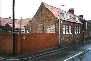
- An Elementary School was built here before 1872. In that year it was rebuilt and enlarged to accomodate 180 children.
- For more on researching school records, see our Schools Research page.
- South Ferriby School has a Website, but it's a bit thin on History.
- Chris JAGGER provides a photograph taken in 2007 of South Ferriby School on Geo-graph.
- The phone number for South Ferriby School is 01652-635-251.
- The "catchment area" for the school is South Ferriby, Horkstow and Saxby-all-Saints. Children from Horkstow and Saxby-all-Saints travel to school by school bus which is free of charge and provided by the local authority.
- Here is a photo of the school, taken by (and copyright of) Gordon WALTON. Gordon advises that this school will close in 2005 and students move to a new school about 1/2 mile away.