
Hide
--- TEST SYSTEM --- TEST SYSTEM --- TEST SYSTEM ---
Hide
Somerby by Grantham
hide
Hide
hide
Hide
hide


Hide
Hide
“SOMERBY, a parish in the wapentake of Winnibriggs, parts of Kesteven, county Lincoln, 3½ miles S.E. of Grantham, its post town and railway station. The village is of small extent. The parish includes the hamlet of Great Humby. The living is a rectory* with the curacy of Humby annexed, in the diocese of Lincoln, value £645. The church, dedicated to St. Mary Magdalen, is an ancient structure with a square tower containing one bell. The interior of the church contains an effigy of a crusader, also two brasses, one bearing date 1509. There is a National school for both sexes."
"GREAT HUMBY, a hamlet in the parish of Somerby, wapentake of Winnibriggs, county Lincoln, 3 miles S.E. of Grantham, and 6 S. W. of Falkingham. The tithes were commuted for zany under an Enclosure Act in 1795.
”
from The National Gazetteer of Great Britain and Ireland - 1868
Hide
The Library at Grantham will prove useful in your research.
- The parish was in the Colsterworth sub-district of the Grantham Registration District.
- In an 1890 district re-organisation, the parish was allocated to the new "Grantham South" sub-district of the Grantham Registration District.
- Check our Census Resource page for county-wide resources.
- The table below gives census piece numbers, where known:
| Census Year | Piece No. |
|---|---|
| 1841 | H.O. 107 / 622 |
| 1851 | H.O. 107 / 2103 |
| 1861 | R.G. 9 / 2347 |
| 1871 | R.G. 10 / 3354 |
| 1891 | R.G. 12 / 2586 |
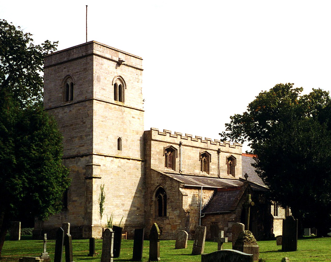
- The Anglican parish church is dedicated to Saint Mary Magdalen.
- The church was apparently built before 1670 and it was entirely restored in 1876.
- The church has some parts of Norman origin.
- The church seats about 120.
- The chapelry at Humbry was formerly the private chapel of the BROWNLOW family. This chapel was restored in 1876.
- Richard CROFT has a photograph of St. Mary Magdalen's Church on Geo-graph, taken in March, 2006.
- Here is a photograph of St. Mary Magdalen's church, taken by Ron COLE (who retains the copyright):
- St. Mary Magdalen parish registers only date from 1730.
- The Lincolnshire FHS has published several marriage and burial indexes for the Beltisloe Deanery to make your search easier.
- Around 1900, the deanery boundaries were re-organized and this parish was placed in the South Grantham Deanery. Researchers should use the indexes above.
- The Primitive Methodists had a small chapel in the parish. Check our Non-Conformist Church Records page for additional resources.
- Check our Church Records page for county-wide resources.
- The parish was in the Colsterworth sub-district of the Grantham Registration District.
- In an 1890 district re-organisation, the parish was allocated to the new "Grantham South" sub-district of the Grantham Registration District.
- Check our Civil Registration page for sources and background on Civil Registration beginning in July 1837.
Somerby is both a parish and a small village about three miles south-east of Grantham. The parish itself is bounded on the north by Londonthorpe parish and to the east by Ropsley parish. The parish covers about 2,155 acres and includes the Chapelry of Humbry.
Old Somerby is a small village, just east of Grantham on the B1176 road. Humby is a hamlet and chapelry in the parish about 3 miles south-east of the main village. If you are planning a visit:
- The village can be accessed off of the A1 motorway south of Grantham. Turn east on to the A52 and cross the B6403 (the Ermine Street) into Old Somerby.
- Visit our touring page for more sources.
The National Gazetteer of Great Britain and Ireland - 1868
"GREAT HUMBY, a hamlet in the parish of Somerby, wapentake of Winnibriggs, county Lincoln, 3 miles S.E. of Grantham, and 6 S. W. of Falkingham. The tithes were commuted for zany under an Enclosure Act in 1795.
- Ask for a calculation of the distance from Somerby by Grantham to another place.
- The village well was sunk and enclosed in 1841.
- Kate JEWELL has a photograph of Grantham Road on Geo-graph, taken in February, 2007. The photo includes the Fox and Hounds Pub.
- These are the names associated with the Fox and Hounds in various directories:
| Year | Person |
|---|---|
| 1842 | Wm, HARRIS, vict. |
| 1868 | George TODD |
| 1871 | George TODD, farmer, grazier and victualler |
| 1882 | William TODD, farmer, grazier and victualler |
| 1900 | William TODD, farmer |
| 1913 | Joseph W. STOTHARD |
| 1930 | Ernest MUSSON |
- See our Maps page for additional resources.
You can see maps centred on OS grid reference SK958338 (Lat/Lon: 52.893124, -0.577462), Somerby by Grantham which are provided by:
- OpenStreetMap
- Google Maps
- StreetMap (Current Ordnance Survey maps)
- Bing (was Multimap)
- Old Maps Online
- National Library of Scotland (Old Ordnance Survey maps)
- Vision of Britain (Click "Historical units & statistics" for administrative areas.)
- English Jurisdictions in 1851 (Unfortunately the LDS have removed the facility to enable us to specify a starting location, you will need to search yourself on their map.)
- Magic (Geographic information) (Click + on map if it doesn't show)
- GeoHack (Links to on-line maps and location specific services.)
- All places within the same township/parish shown on an Openstreetmap map.
- Nearby townships/parishes shown on an Openstreetmap map.
- Nearby places shown on an Openstreetmap map.
- A tablet was placed in the church in 1919 in memory of the men who fell in the Great War.
For a photograph of both War Memorial plaques and the list of names on them, see the Roll of Honour site.
- This place was an ancient parish in Lincoln county and became a modern Civil Parish when those were established.
- The parish was in the ancient Winnibriggs Wapentake in the South Kesteven district in the parts of Kesteven.
- In December, 1894, this parish was abolished and reformed as "Old Somerby" Civil Parish to resolve confusions with the other Somerby in Lincolnshire.
- For today's local governance, contact the South Kesteven District Council.
- Bastardy cases would be heard in the Spittlegate petty sessional hearings.
- In 1796 the chapelry of Humber had its Common Lands enclosed.
- As a result of the Poor Law Amendment Act reforms of 1834, the parish became part of the Grantham Poor Law Union.
- A National School (later a Public Elementary School) was built here in 1844 to hold up to 50 children.
- For more on researching school records, see our Schools Research page.