
Hide
--- TEST SYSTEM --- TEST SYSTEM --- TEST SYSTEM ---
Hide
Snitterby
hide
Hide
hide
Hide
hide


Hide
Hide
Snitterby, par. and vil., Lincolnshire - par., 1,640 ac., pop. 274; vil., 4½ miles SE. of Kirton in Lindsey; P.O.; in vicinity is Snitterby House, seat.
From: John BARTHOLOMEW's "Gazetteer of the British Isles (1887)"
Hide
The Caistor Library is an excellent resource with a Local History section and a Family History section.
Alternatively, you can use the Market Rasen Library as a resource, also.
- The parish was in the Market Rasen sub-district of the Caistor Registration District.
- The North Lincolnshire Library holds copies of the census returns for 1841, 1851, 1881, 1891 and 1901.
- Check our Census Resource page for county-wide resources.
- The table below gives census piece numbers, where known:
| Census Year | Piece No. |
|---|---|
| 1841 | H.O. 107 / 644 |
| 1851 | H.O. 107 / 2115 |
| 1861 | R.G. 9 / 2395 |
| 1871 | R.G. 10 / 3424 |
| 1891 | R.G. 12 / 2624 |
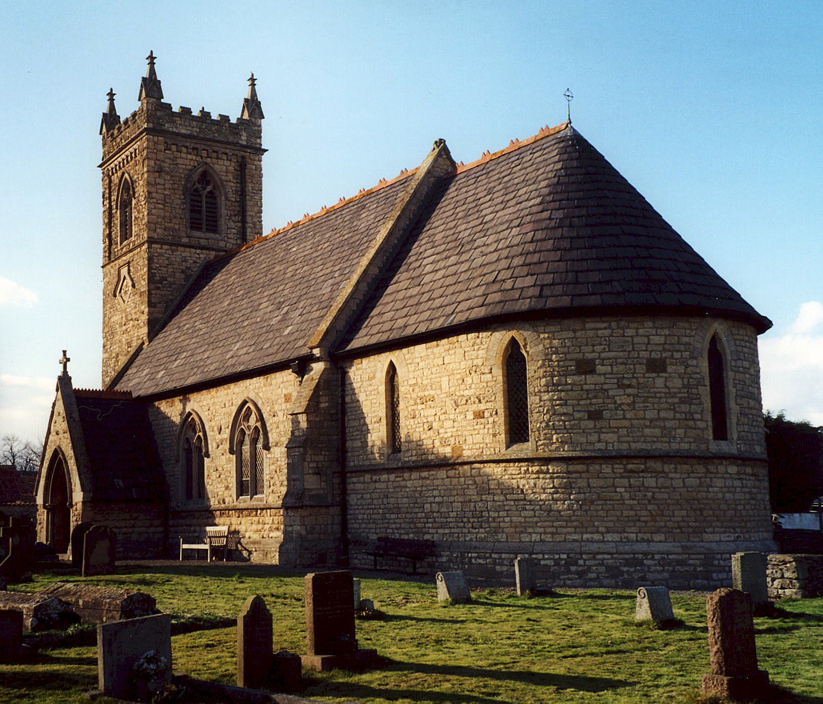
- The Anglican parish church is dedicated to Saint Nicholas.
- The church was erected on the site of an older structure in 1780 and was rebuilt in 1866-7. A tower was completed in 1894.
- The church seats around 180.
- There is a photograph of St. Nicholas Church on the Wendy PARKINSON English Church Photo web site.
- Richard CROFT has a photograph of St. Nicholas Church on Geo-graph, taken in November, 2005.
- Here is a photo of St. Nicholas Church, taken by Ron COLE (who retains the copyright):
- The parish register (for this parish only) dates from 1858. Earlier entries are included in those of Waddingham.
- The Lincolnshire FHS has published several marriage indexes and a burial index for the Yarborough Deanery to make your search easier.
- Some Directories of the 1900s place the parish in the Corringham Deanery.
- The Wesleyan Methodists built a chapel here, as did the Primitive Methodists. For information and assistance in researching these chapels, see our non-conformist religions page.
- Check our Church Records page for county-wide resources.
- The parish was in the Market Rasen sub-district of the Caistor Registration District.
- Check our Civil Registration page for sources and background on Civil Registration which began in July, 1837.
Snitterby is both a village and a parish which sit about 9 miles south of Brigg and 11 miles northwest of Market Rasen. Waddingham parish is to the north. The parish covers about 1,700 acres.
If you are planning a visit:
- Fishing is popular on the Ancholme River.
- By automobile, take the A15 (Ermine Street) north from the A631 Trunk road. After about two miles, turn east (right) into Snitterby village.
- Bus service is available. Check our Transports page.
- Stop by the Village Hall and get a schedule of current events. Jonathan THACKER has a photograph of the Village Hall on Geo-graph, taken in December, 2011.
- Visit our touring page for visitor services.
The National Gazetteer of Great Britain and Ireland - 1868
- Ask for a calculation of the distance from Snitterby to another place.
- The Royal Oak Public House was the centre if the village cimmunity. David WRIGHT has a photograph of the Royal Oak on Geo-graph, taken in April, 2008:
- These are the names associated with the Royal Oak in various directories:
| Year | Proprietor |
|---|---|
| 1868 | John WILKINSON |
| 1885 | Henry SIMS, carrier |
| 1913 | Thomas SIMPSON |
| 1919 | Thomas SIMPSON |
- You might like the 1906 inch-to-the-mile map of North East Lincolnshire.
You can see maps centred on OS grid reference SK985948 (Lat/Lon: 53.440883, -0.518503), Snitterby which are provided by:
- OpenStreetMap
- Google Maps
- StreetMap (Current Ordnance Survey maps)
- Bing (was Multimap)
- Old Maps Online
- National Library of Scotland (Old Ordnance Survey maps)
- Vision of Britain (Click "Historical units & statistics" for administrative areas.)
- English Jurisdictions in 1851 (Unfortunately the LDS have removed the facility to enable us to specify a starting location, you will need to search yourself on their map.)
- Magic (Geographic information) (Click + on map if it doesn't show)
- GeoHack (Links to on-line maps and location specific services.)
- All places within the same township/parish shown on an Openstreetmap map.
- Nearby townships/parishes shown on an Openstreetmap map.
- Nearby places shown on an Openstreetmap map.
For a photograph of the Snitterby War Memorial and the names on it, see the Roll of Honour site.
The names on the War Memorial (Per the Imperial War Museum are:
- Andrew, J. H.
- Ashley, A.
- Ashley, H.
- Ashley, S.
- Jacklin, A.
- Jacklin, W.
- Kirby, A. L.
- Wilson, G. E.
- Snitterby was for centuries a village, township and chapelry in the parish of Waddingham.
- The parish was in the east division of the ancient Aslacoe Wapentake in the West Lindsey district in the parts of Lindsey.
- The Snitterby Parish Council has not adopted an online presence as of 2015.
- Some Directories of the 1900s place the parish in the North Lindsey division of the county.
- Today's district governance is provided by the West Lindsey District Council. The same limits apply.
- Bastardy cases would have been heard in the Brigg petty session hearings.
- After the Poor Law Amendment Act of 1834, this parish became part of the Caistor Poor Law Union.
- A National School was built here in 1862 to hold up to 70 children.
- For more on researching school records, see our Schools Research page.