
Hide
--- TEST SYSTEM --- TEST SYSTEM --- TEST SYSTEM ---
Hide
Skillington
hide
Hide
hide
Hide
hide
Hide
Hide
“SKILLINGTON, a parish in the wapentake of Beltisloe, parts of Kesteven, county Lincoln, 7 miles S. of Grantham, its post town, and 6 W. of the Corby railway station. The village, which is of small extent, is situated on the S.W. border of the county. The living is a vicarage in the diocese of Lincoln, value £105, in the patronage of the dean and chapter. The church, dedicated to St. James, has a tower containing two bells. The parochial charities produce about £1 per annum. There is a school for both sexes, supported principally by Sir J. M. Cholmeley and C. Turner, Esq. The Wesleyans have a place of worship. The Earl of Dysart and Sir M. J. Cholmeley, Bart., are lords of the manor."
”
from The National Gazetteer of Great Britain and Ireland - 1868
Hide
The Library at Grantham will prove useful in your research.
- The parish was in the Denton sub-district of the Grantham Registration District.
- In an 1890 re-organization,the parish was allocated to the new "Grantham North" subdistrict of the Grantham Registration District.
- Check our Census Resource page for county-wide resources.
- The table below gives census piece numbers, where known:
| Census Year | Piece No. |
|---|---|
| 1841 | H.O. 107 / 622 |
| 1851 | H.O. 107 / 2102 |
| 1861 | R.G. 9 / 2348 |
| 1871 | R.G. 10 / 3357 |
| 1891 | R.G. 12 / 2582 |
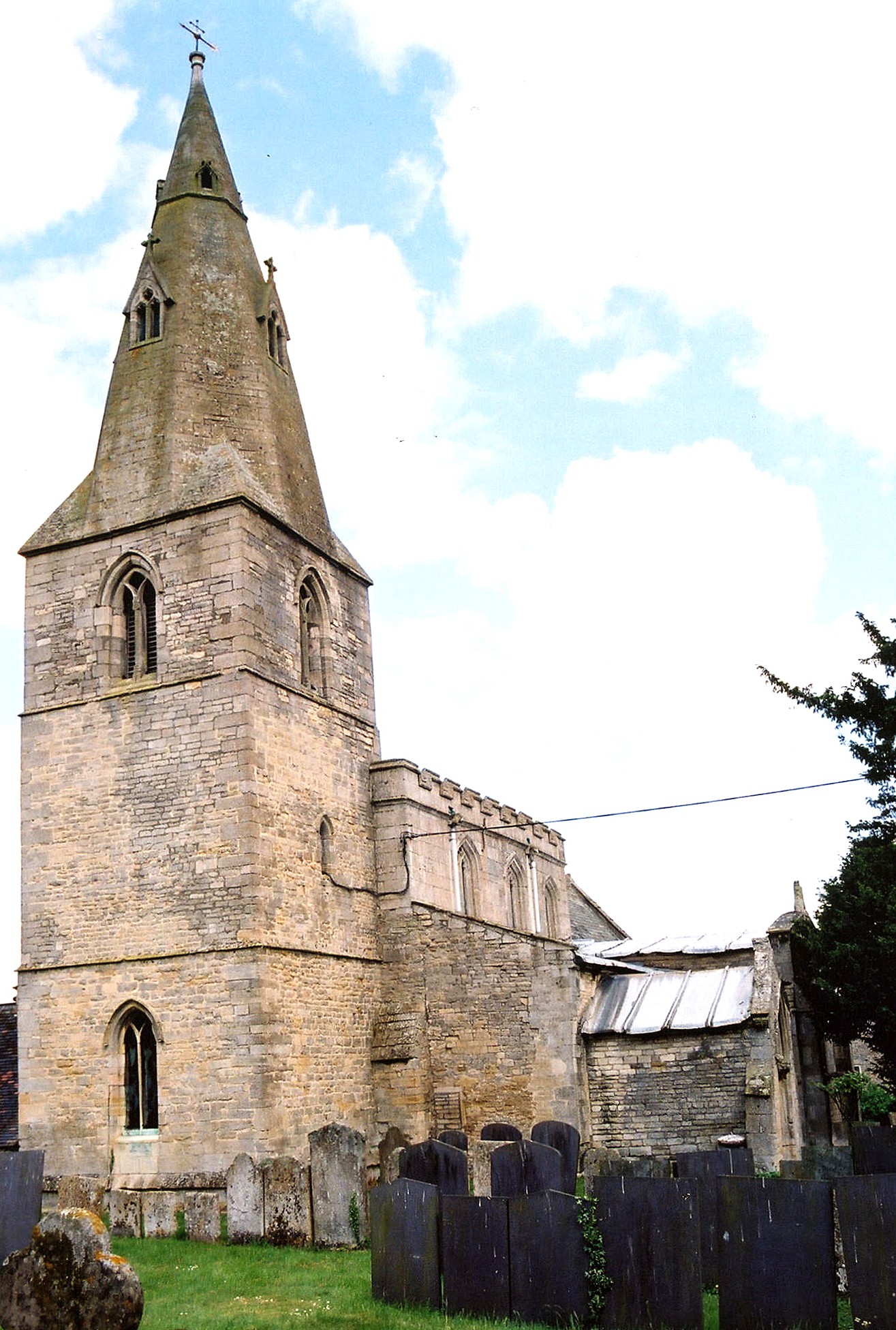
- The Anglican parish church is dedicated to Saint James.
- The church dates from the 11th century.
- Portions of the church appear to be of late Saxon and early Norman origin.
- The church tower dates from the 13th century.
- The church is a Grade I listed building with British Heritage.
- The church seats 205.
- J HANNAH-BRIGGS has a photograph of the church interior at Geo-graph, taken in 2012.
- Here is a photo of St. James Church, taken by Ron COLE (who retains the copyright):
- The Anglican parish register dates from 1542.
- The Lincolnshire FHS has published several marriage and burial indexes for the Beltisloe Deanery to make your search easier.
- The Wesleyan Methodists had a small chapel here, built in 1847. For information and assistance in researching these chapels, see our non-conformist religions page.
- Check our Church Records page for county-wide resources.
- The parish was in the Denton sub-district of the Grantham Registration District.
- In an 1890 re-organization,the parish was allocated to the new "Grantham North" subdistrict of the Grantham Registration District.
- Check our Civil Registration page for sources and background on Civil Registration which began in July, 1837.
Skillington is both a parish and a small village about eight miles south of Grantham. The parish itself is bounded on the south by Colsterworth parish and to the east by Easton township. Sproxton parish in Leicestershire lies to the west. The parish covers 2,240 acres.
Skillington is a small village, off the main roads. If you are planning a visit:
- The village can be accessed off of the A1 motorway south of Grantham. Turn west at Easton.
- Andrew TATLOW has a photograph of the Village Sign as you enter Skillington on Geo-graph, taken in October, 2013.
- Kate JEWELL has a photograph of the town green at Geo-graph, taken in April, 2012.
- Visit our touring page for more sources.
The National Gazetteer of Great Britain and Ireland - 1868
- Ask for a calculation of the distance from Skillington to another place.
- The Milestone Society has a photograph of the Wayside Cross base and shaft on Geo-graph, taken in 2018.
- A young Isaac NEWTON used to visit his three aunts who lived in Skillington as a lad. He even began his schooling here.
- Timothy HEATON has a photograph of the Memorial window to Charles HUDSON on Geo-graph, taken in September, 2007. HUDSON was part of a team of seven to make the first successful ascent of the Matterhorn in 1865.
- Alpin STEWART has a photograph of the Cross Swords Inn on Geo-graph, taken in September, 2019.
Proprietors of the Cross Swords inn:
| Year | Person |
|---|---|
| 1872 | John WILSON, butcher, baker & victualler |
| 1896 | Arthur WILSON, butcher & carrier |
| 1913 | --- not listed --- |
| 1919 | --- not listed --- |
- See our Maps page for additional resources.
You can see maps centred on OS grid reference SK897258 (Lat/Lon: 52.82228, -0.670305), Skillington which are provided by:
- OpenStreetMap
- Google Maps
- StreetMap (Current Ordnance Survey maps)
- Bing (was Multimap)
- Old Maps Online
- National Library of Scotland (Old Ordnance Survey maps)
- Vision of Britain (Click "Historical units & statistics" for administrative areas.)
- English Jurisdictions in 1851 (Unfortunately the LDS have removed the facility to enable us to specify a starting location, you will need to search yourself on their map.)
- Magic (Geographic information) (Click + on map if it doesn't show)
- GeoHack (Links to on-line maps and location specific services.)
- All places within the same township/parish shown on an Openstreetmap map.
- Nearby townships/parishes shown on an Openstreetmap map.
- Nearby places shown on an Openstreetmap map.
Adrian S. PYE has a photograph of the Memorial to RAF Sgt. John Newton on Geo-graph, taken in June, 2020.
Adrian has a close-up of the plaque on Geo-grapsh as well, also taken in June, 2020.
- This place was an ancient parish of Lincolnshire and became a modern Civil Parish when those were formed.
- The parish was in the ancient Winnibriggs and Threo Wapentake in the South Kesteven district in the parts of Kesteven.
- Kelly's 1900 Directory of Lincolnshire reports that the parish is in the Betisloe Wapentake.
- It was also within the Soke of Grantham.
- On 1 April, 1965, this parish was reduced by 1 acre to enlarge Buckminster Civil Parish in Leicestershire. Buckminster transferred a 1 acre parcel to Skillington Civil Parish at the same time (i.e. a "land swap").
- On 1 April, 1965, this parish gained 3 acres from Sproxton Civil Parish in Leicestershire.
- For today's district governance, contact the South Kesteven District Council.
- Bastardy cases would be heard in the Spittlegate (Grantham) petty session hearings.
- The Common Land was enclosed here around 1798.
- As a result of the 1834 Poor Law Amendment Act reforms, the parish became part of the Grantham Poor Law Union.
- A Public Elementary School was built here before 1885 and enlarged in 1894 for up to 120 children.
- For more on researching school records, see our Schools Research page.