
Hide
--- TEST SYSTEM --- TEST SYSTEM --- TEST SYSTEM ---
Hide
Sixhills
hide
Hide
hide
Hide
hide
Hide
Hide
Sixhills.-- par., Lincolnshire, 4 miles SE. of Market Rasen, 1,962 ac., pop. 175.
From: John BARTHOLOMEW's "Gazetteer of the British Isles (1887)"
Hide
The Caistor Library is an excellent resource with a Local History section and a Family History section.
Alternatively, you can use the Market Rasen Library as a resource, also.
- The parish was in the Market Rasen sub-district of the Caistor Registration District.
- Check our Census Resource page for county-wide resources.
- The table below gives census piece numbers, where known:
| Census Year | Piece No. |
|---|---|
| 1841 | H.O. 107 / 644 |
| 1851 | H.O. 107 / 2115 |
| 1861 | R.G. 9 / 2396 |
| 1871 | R.G. 10 / 3426 |
| 1891 | R.G. 12 / 2624 |
| Sixhills, Methodist (United Free) |
- A Gilbertine Priory, dedicated to the Blessed Virgin, was endowed here in the reign of King Stephen (Sixth Century).
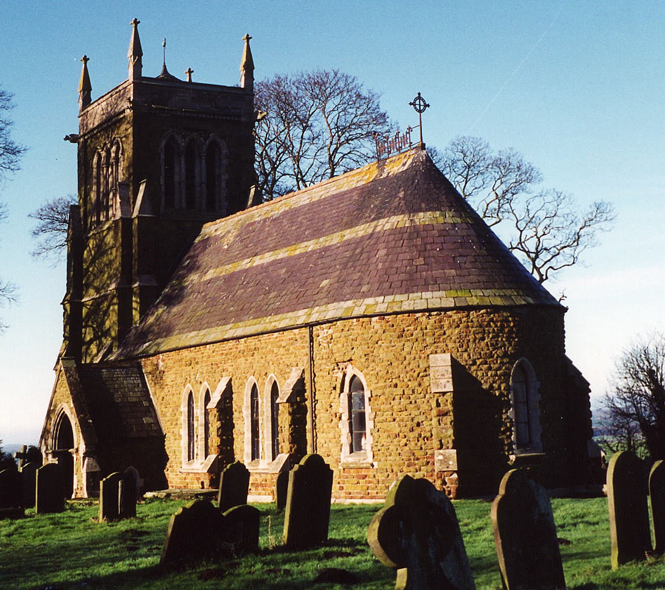
- The Anglican parish church is dedicated to All Saints.
- The church was taken down and rebuilt in 1869.
- The church's gabel turret was struck by lightning in 1871. A new bell tower was built to replace it in 1875. The tower was rebuilt in 1902.
- The church seats 75.
- Richard CROFT has a photograph of shade-covered All Saints Church on Geo-graph, taken in November, 2005.
- Here is a photo of All Saints Church, taken by Ron COLE (who retains the copyright):
- The Anglican parish register dates from 1672 for baptisms and burials and from 1682 for marriages.
- The Lincolnshire FHS has published several marriage indexes and a burial index for the Westwold Deanery to make your search easier.
- The National Burial Index has 208 burials recorded for All Saints between 1813 and 1900.
- The Society of Genealogists has microfiche copies of the parish register for baptism and burials 1672-1812 and marriages 1672-1974.
- The Free Methodists had a chapel built here in 1886. For information and assistance in researching chapel records, see our non-conformist religions page.
- Check our Church Records page for county-wide resources.
- The parish was in the Market Rasen sub-district of the Caistor Registration District.
- Check our Civil Registration page for sources and background on Civil Registration which began in July, 1837.
This village and parish lie about 4.5 miles south of Market Rasen and a little over 10 miles west of Louth. Just to the north lies North Willingham parish. The parish covers about 1,900 acres.
If you are planning a visit:
- Let's hope they've trimmed the bushes around this signpost photographed by David WRIGHT and stored on Geo-graph, taken in June, 2006.
- See our touring page for visitor services.
The National Gazetteer of Great Britain and Ireland - 1868
- Ask for a calculation of the distance from Sixhills to another place.
Christian or Christina Bruce, sister of Robert Bruce, KIng of Scotland, was sent into solitary confinement at the Gilbertine nunnery at Sixhills in Lincolnshire, while her sister Mary and Bruce's supporter Isabella MacDUFF were imprisoned in cages. Christian spent eight years as an English prisoner, and returned to Scotland in October 1314.
- See our Maps page for additional resources.
You can see maps centred on OS grid reference TF170871 (Lat/Lon: 53.367824, -0.24306), Sixhills which are provided by:
- OpenStreetMap
- Google Maps
- StreetMap (Current Ordnance Survey maps)
- Bing (was Multimap)
- Old Maps Online
- National Library of Scotland (Old Ordnance Survey maps)
- Vision of Britain (Click "Historical units & statistics" for administrative areas.)
- English Jurisdictions in 1851 (Unfortunately the LDS have removed the facility to enable us to specify a starting location, you will need to search yourself on their map.)
- Magic (Geographic information) (Click + on map if it doesn't show)
- GeoHack (Links to on-line maps and location specific services.)
- All places within the same township/parish shown on an Openstreetmap map.
- Nearby townships/parishes shown on an Openstreetmap map.
- Nearby places shown on an Openstreetmap map.
- The parish was in the East division of the ancient Wraggoe Wapentake in the West Lindsey district in the parts of Lindsey.
- Kelly's 1900 Directory of Lincolnshire places the parish, perhaps erroneously, in the East Lindsey district of the county. The 1913 edition does the same.
- Today's district governance is provided by the West Lindsey District Council.
- Bastardy cases would be heard in the Wragby petty session hearings.
- As a result of the 1834 Poor Law Amendment Act, this parish became part of the Caistor Poor Law Union.
- An Infant's School was built here in 1874 to hold 30 children. This was closed in 1902 and the children of the parish were sent to school in North WIllingham and Hainton.
< - For more on researching school records, see our Schools Research page.