
Hide
--- TEST SYSTEM --- TEST SYSTEM --- TEST SYSTEM ---
Hide
Owmby by Spital
hide
Hide
hide
Hide
hide


Hide
Hide
“OWMBY, a parish in the E. division of the wapentake of Aslacoe, parts of Lindsey, county Lincoln, 7 miles W. of Market Rasen, its post town, and 4 S.E. of Spitted. The village, which is of small extent, is chiefly agricultural. The living is a rectory* in the diocese of Lincoln, value £330, in the patronage of the Duchy of Lancaster. The church, dedicated to SS. Peter and Paul, is an ancient edifice. The register dates from 1700. There is a National school, also a place of worship for the Primitive Methodists. Colonel Dalton is lord of the manor."
”
from The National Gazetteer of Great Britain and Ireland - 1868
Hide
- The parish was in the North-East sub-district of the Lincoln Registration District.
- For the 1901 census, check our Census Surname Extract page for your kin. Your additions are welcome.
- Check our Census Resource page for county-wide resources.
- The table below gives census piece numbers, where known:
| Census Year | Piece No. |
|---|---|
| 1841 | H.O. 107 / 641 |
| 1861 | R.G. 9 / 2364 |
| 1871 | R.G. 10 / 3377 |
| 1891 | R.G. 12 / 2596 |
| 1901 | R.G. 13 / 3098 |
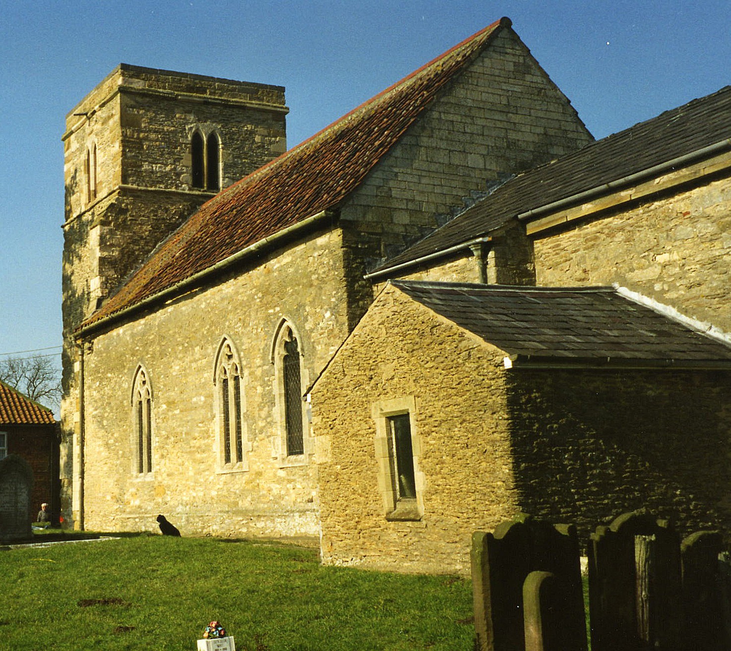
- The Anglican parish church is dedicated to Saint Peter and Saint Paul.
- Parts of the structure date to Norman times.
- The church chancel was built around 1808.
- The church seats 200 people.
- A photograph of St. Peter and St. Paul church is at the Wendy PARKINSON English Church Photographs site.
- J. HANNAH-BRIGGS has a photograph of the church interior on Geo-graph, taken in June, 2013.
- Here is a photograph of Saint Peter and Paul Church taken by Ron COLE (who retains the copyright):
- The Anglican parish register dates from 1700. There are no surviving parish register entries prior to 1700 at the Lincoln Archives.
- The Lincolnshire FHS has a Loan Library service which has the parish registers on microfiche for Baptisms from 1700 to 1812 and Marriages from 1700 to 1812.
- The LFHS has published several marriage indexes and a burial index for the Lawres Deanery to make your search easier.
- The Primitive Methodists had a small chapel here by 1881 and built another small one in 1903. For information and assistance in researching these chapels, see our non-conformist religions page.
- Check our Church Records page for county-wide resources.
- The parish was in the North-East sub-district of the Lincoln Registration District.
- Check our Civil Registration page for sources and background on Civil Registration which began in July, 1837.
Owmby-by-Spital is both a village and a parish 11 miles north of the city of Lincoln, 8 miles west of Market Rasen, near the crossroads known as "Spital" for the hospital that used to be there (see Hemswell). Normanby parish lies to the north and Saxby parish to the south. The parish covers about 1,600 acres.
Owmby-by-Spital (often, just "Owmby") village is just east of the Roman Road known as Ermine Street and borders Normanby village to the north. If you are planning a visit:
- The village of Owmby sits 2.5 miles east of the Roman Road now known as "Ermine Street".
- Take the A15 north out of Lincoln for about seven miles. Just before you get to the to the A631, turn right to Owmby.
- See our touring page for more sources.
The National Gazetteer of Great Britain and Ireland - 1868
- Ask for a calculation of the distance from Owmby by Spital to another place.
- See our Maps page for additional resources.
You can see maps centred on OS grid reference TF001875 (Lat/Lon: 53.374727, -0.496402), Owmby by Spital which are provided by:
- OpenStreetMap
- Google Maps
- StreetMap (Current Ordnance Survey maps)
- Bing (was Multimap)
- Old Maps Online
- National Library of Scotland (Old Ordnance Survey maps)
- Vision of Britain (Click "Historical units & statistics" for administrative areas.)
- English Jurisdictions in 1851 (Unfortunately the LDS have removed the facility to enable us to specify a starting location, you will need to search yourself on their map.)
- Magic (Geographic information) (Click + on map if it doesn't show)
- GeoHack (Links to on-line maps and location specific services.)
- All places within the same township/parish shown on an Openstreetmap map.
- Nearby townships/parishes shown on an Openstreetmap map.
- Nearby places shown on an Openstreetmap map.
- This place was an ancient parish in Lincoln county and it became a modern Civil Parish when those were established.
- The parish was in the ancient Aslacoe Wapentake in the West Lindsey district in the parts of Lindsey.
- Today's district governance is provided by the West Lindsey District Council.
- Bastardy cases would be heard in the Lincoln Bail and Close petty session hearings.
- As a result of the Poor Law Amendment Act reforms of 1834, the parish became part of the Lincoln Poor Law Union.
- A school was built here in 1836, but was closed by 1881.
- Owmby was united with Normanby into a school board district on 18 Jan. 1870. Most children in the parish attended school in Normanby.
- For more on researching school records, see our Schools Research page.