
Hide
--- TEST SYSTEM --- TEST SYSTEM --- TEST SYSTEM ---
Hide
Minting
hide
Hide
hide
Hide
hide


Hide
Hide
“MINTING, a parish in the S. division of the wapentake of Gartree, parts of Lindsey, county Lincoln, 6 miles N.W. of Horncastle, its post town, and 7 N. of the Southrey and Bardney railway station. The village, which is small, is situated on a branch of the river Witham, and is wholly agricultural. About one half of the land is indifferent pasture, and the remainder arable and woodland. Here was formerly an alien priory of Benedictine monks, which was given by Henry V. to the Carthusian priory of Mount Grace, and subsequently came into the possession of the Dean and Chapter of Westminster. The living is a vicarage* and rectory in the diocese of Lincoln, value £437, in the patronage of St. John's College, Cambridge. The church, dedicated to St. Andrew, has a turret, and once belonged to the Abbey of Leyr, in France. The interior of the church contains a carved screen, which divides the chancel from the nave. There is a National school for both sexes, erected in 1851. The manor belongs to St. John's College, Cambridge."
”
from The National Gazetteer of Great Britain and Ireland - 1868
Hide
- The parish was in the Wragby sub-district of the Horncastle Registration District.
- Check our Census Resource page for county-wide resources.
- The table below gives census piece numbers, where known:
| Census Year | Piece No. |
|---|---|
| 1841 | H.O. 107 / 640 |
| 1851 | H.O. 107 / 2107 |
| 1861 | R.G. 9 / 2365 |
| 1871 | R.G. 10 / 3378 |
| 1891 | R.G. 12 / 2597 |
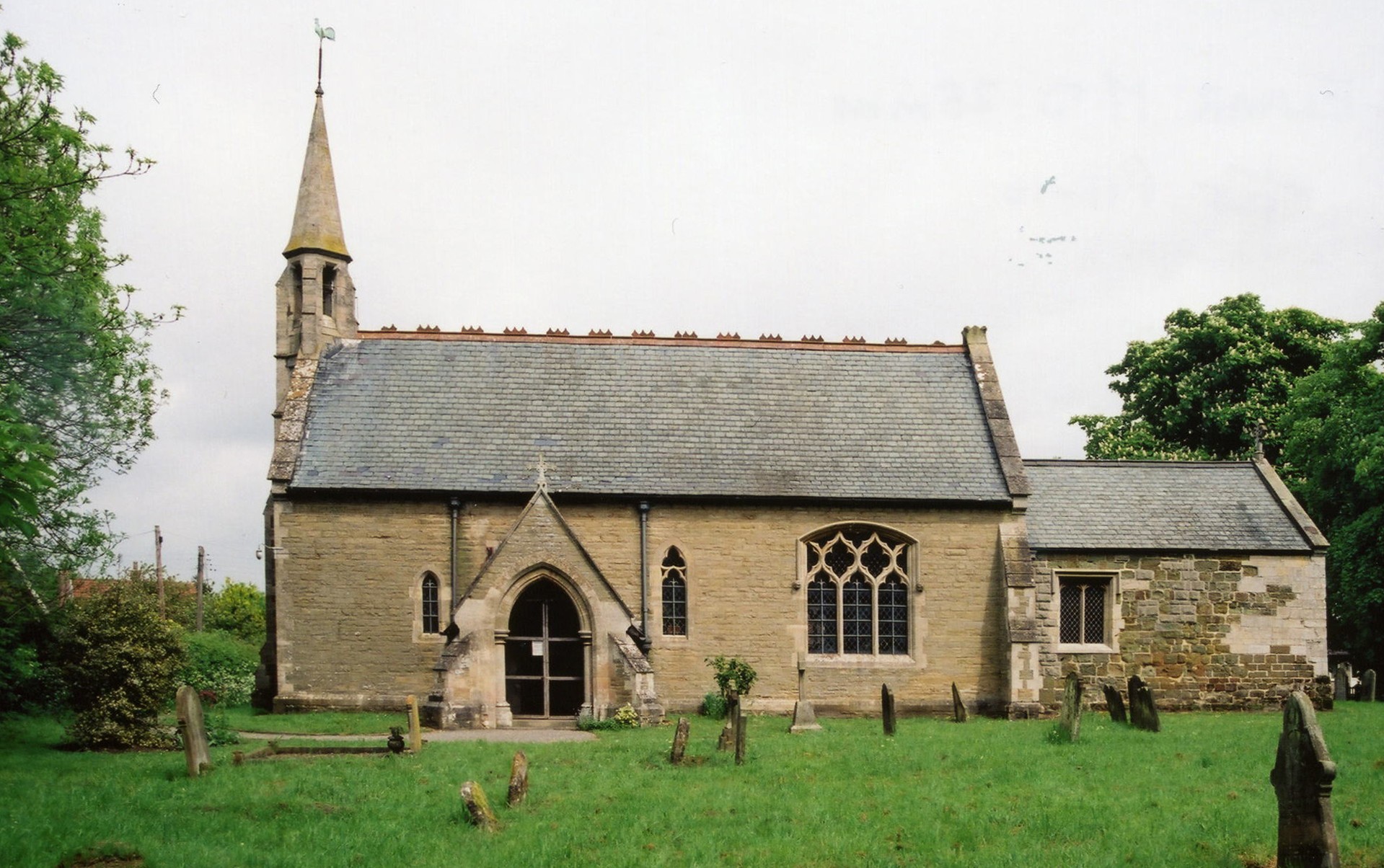
- The Anglican parish church is dedicated to Saint Andrew.
- The church was rebuilt in 1863.
- The church seats 150 people.
- A photograph of the Anglican parish church is at the Wendy PARKINSON English Church Photographs site.
- Gary BROTHWELL has a photograph of St. Andrew's Church on Geo-graph, taken in August, 2010.
- Here is a photograph of Saint Andrew's Church supplied by Ron COLE (who retains the copyright):
- The Anglican parish register dates from 1562.
- The LFHS has published several marriage indexes for the Horncastle Deanery to make your search easier.
- The Wesleyan Methodists built two chapels here in 1838. Check our Non-Conformist Church Records page for additional resources.
- Check our Church Records page for county-wide resources.
- The parish was in the Wragby sub-district of the Horncastle Registration District.
- Check our Civil Registration page for sources and background on Civil Registration which began in July, 1837.
Minting is both a village and a parish, 6 miles north-west of Horncastle. Gautby parish lies to the south and Baumber parish to the east. The parish covers about 2,600 acres.
If you are planning a visit:
- Visit our touring page for more sources.
The National Gazetteer of Great Britain and Ireland - 1868
- Ask for a calculation of the distance from Minting to another place.
- The Sebastopol Inn started out as a nameless beerhouse, but got its name when a soldier, recently returned from the Crimean War, drowned in a nearby dyke.
- The Sebastopol Inn was a popular conversation spot. The inn is still functioning and has its own website.
- Gary BROTHWELL has a photograph of the Sebastopol Inn on Geo-graph, taken in August, 2010.
- These are the names associated with the place in various directories:
| Year | Person |
|---|---|
| 1842 | -- not listed by name-- |
| 1868 | Thomas MacKINDER, beer retailer |
| 1872 | Mrs. Elizabeth MacKINDER, vict. |
| 1882 | Charles Albert BROWN, vict. |
| 1900 | Mrs. Maria WRAY, shopkeeper |
| 1913 | Robert Wm. PINNING |
| 1930 | Joseph HEWITT |
- See our Maps page for additional resources.
You can see maps centred on OS grid reference TF187734 (Lat/Lon: 53.244359, -0.222643), Minting which are provided by:
- OpenStreetMap
- Google Maps
- StreetMap (Current Ordnance Survey maps)
- Bing (was Multimap)
- Old Maps Online
- National Library of Scotland (Old Ordnance Survey maps)
- Vision of Britain (Click "Historical units & statistics" for administrative areas.)
- English Jurisdictions in 1851 (Unfortunately the LDS have removed the facility to enable us to specify a starting location, you will need to search yourself on their map.)
- Magic (Geographic information) (Click + on map if it doesn't show)
- GeoHack (Links to on-line maps and location specific services.)
- All places within the same township/parish shown on an Openstreetmap map.
- Nearby townships/parishes shown on an Openstreetmap map.
- Nearby places shown on an Openstreetmap map.
- This place was an ancient parish of Lincolnshire and became a modern Civil Parish when those were established.
- The parish was in the southern division of the ancient Gartree Wapentake in the East Lindsey district in the parts of Lindsey.
- For today's district governance, see the East Lindsey District Council.
- Bastardy cases would be heard in the Horncastle petty session hearings.
- A charity was established by George ASHTON, date unknown, of the interest from £80 annually.
- As a result of the 1834 Poor Law Amendment Act, the parish became part of the Horncastle Poor Law Union.
Year Inhabitants 1801 190 1811 192 1821 270 1831 301 1841 280 1851 408 1871 406 1881 347 1891 336 1901 335 1911 262 1921 206
- A school was erected here in 1851, but abandoned when the new school was built.
- The school erected in 1876 could accomodate 100 children. Attendance in 1912 was only 50.
- For more on researching school records, see our Schools Research page.