
Hide
--- TEST SYSTEM --- TEST SYSTEM --- TEST SYSTEM ---
Hide
Heapham
hide
Hide
hide
Hide
hide
Hide
Hide
Heapham, par., mid. Lincolnshire, 4 miles SE. of Gainsborough, 1,250 ac., pop. 144; P.O.
From: John BARTHOLOMEW's "Gazetteer of the British Isles (1887)"
Hide
The Gainsborough Library is an excellent resource with both a Local History section and a Family History section.
- The parish was in the Willingham sub-district of the Gainsborough Registration District.
- An 1890 redistricting plan allocated the parish to the Marton sub-district of the Gainsborough Registration District.
- The North Lincolnshire Library holds a copy of the parish census returns for 1841 through 1901.
- Check our Census Resource page for county-wide resources.
- Below are the census Piece Numbers, where known:
| Census Year | Piece Numbers |
|---|---|
| 1841 | H.O. 107 / 637 |
| 1861 | R.G. 9 / 2410 |
| 1871 | R.G. 10 / 3448 |
| 1891 | R.G. 12 / 2636 |
| Heapham, Methodist (Wesleyan) |
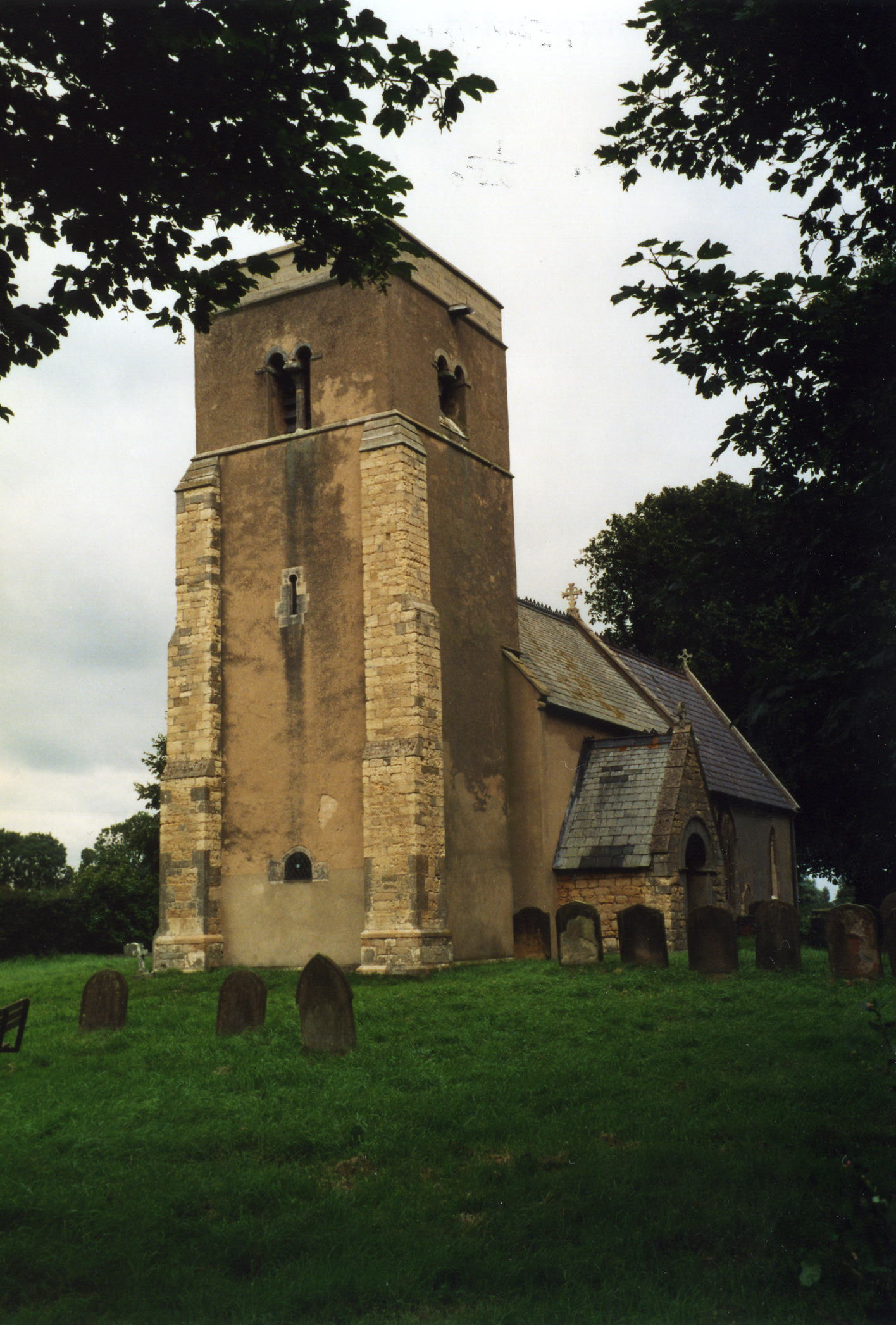
- All that remains of the original Saxon church is the western tower. The rest of the church is of Norman origin.
- The Anglican parish church is dedicated to All Saints.
- The church was restored in 1868-70.
- The church seats 120.
- The church is Grade II listed with British Heritage.
- There is a photograph of All Saints Church on the Wendy PARKINSON web site.
- Here is a photograph of All Saints Church supplied by Ron COLE (who retains the copyright):
- Parish registers exist from 1558, but the Bishop's transcripts only go back to 1563.
- Parish registers are on file at the Society of Genealogists, covering 1558 - 1720.
- The North Lincolnshire Library holds a copy of the parish register entries for baptisms 1558-1812, burials 1558-1812 and marriages 1558-1837.
- The Lincolnshire FHS has published several marriage and burial indexes for the Corringham Deanery to make your search easier.
- The Wesleyan Methodists built a chapel here in 1842. The built a new one in 1897.
- The Wesleyan chapel is Grade II listed with British Heritage.
- Richard CROFT has a photograph of the Wesleyan Methodist chapel on Geo-graph, taken in 2007.
- For more on these chapels and their records, check our Non-Conformist Church Records page for additional resources.
- Check our Church Records page for county-wide resources.
- The parish was in the Willingham sub-district of the Gainsborough Registration District.
- An 1890 redistricting plan allocated the parish to the Marton sub-district of the Gainsborough Registration District.
- Check our Civil Registration page for sources and background on Civil Registration which began in July, 1837.
Heapham is both a small parish and a small village about 4 miles east of Gainsborough and 10 miles south of Scunthorpe. The parish itself is bordered on the north by Springthorpe parish, on the east by Harpswell parish, to the west and south by Upton cum Kexby parish. The parish covers about 1,250 acres.
Heapham village is on a small rise, near the source of a rivulet. If you are planning a visit:
- Take the A631 trunk road east out of Gainsborough and at Corringham turn south. Drive through the village of Springthorpe and the village of Heapham will be about a half mile further south.
- Visit our touring page for more sources.
The National Gazetteer of Great Britain and Ireland - 1868
- Ask for a calculation of the distance from Heapham to another place.
- In 1842, the landowners were Wm. HUTTON, R. OTTER and R. DUCKLE. There were several small proprietors as well.
- In 1872, the same families owned the property here.
- In 1900, Lieutenant-Colonel George Holden HUTTON was the principal landowner. There were also a number of small freeholders.
- See our Maps page for additional resources.
You can see maps centred on OS grid reference SK876883 (Lat/Lon: 53.384557, -0.684843), Heapham which are provided by:
- OpenStreetMap
- Google Maps
- StreetMap (Current Ordnance Survey maps)
- Bing (was Multimap)
- Old Maps Online
- National Library of Scotland (Old Ordnance Survey maps)
- Vision of Britain (Click "Historical units & statistics" for administrative areas.)
- English Jurisdictions in 1851 (Unfortunately the LDS have removed the facility to enable us to specify a starting location, you will need to search yourself on their map.)
- Magic (Geographic information) (Click + on map if it doesn't show)
- GeoHack (Links to on-line maps and location specific services.)
- All places within the same township/parish shown on an Openstreetmap map.
- Nearby townships/parishes shown on an Openstreetmap map.
- Nearby places shown on an Openstreetmap map.
- An airfield was opened here in 1944 as "RAF Sturgate", but it opened too late to be of operational use.
- The field was closed down between 1946 and 1953, but saw further service as an RAF base until 1964.
- The field is currently an unlicensed aerodrome used by Eastern Air Executive and the Lincoln Aero Club. There are no scheduled flights to this airport.
There is a single military grave in the churchyard for Pte. H. STREETS, 5th Sherwood Foresters. For more on it, see the Roll of Honour site.
- The name Heapham comes from the Old English heope+ham or heopa+hamm for "homestead where rose-hips or brambles grow". The name appears in the 1086 Domesday Book as Iopeham.
Anthony D. MILLS, "A Dictionary of English Place-Names," Oxford University Press, 1991.
- White's 1842 Directory lists the following names in the parish: Wm. FOSTER, John HERRING, Jonathan HUTCHINSON, Thomas ISAAC, Francis KETTON, Wm. LAMBERT, Samuel PLATT, Geo. PROCTOR, Thos. SCOTT, Joshua STEVENSON, John STORY, Rev. James STOVIN and Benjamin WILLEY.
- White's 1872 Directory lists the following surnames in the parish: ANYAN, BARRATT, BARTHORP, BURTON, CAMMACK, HIRD, HUTCHINSON, MILBURN, PLATT, PLUMPTON, SILLS, STOREY, STEPHENSON, VON STURMER, WEBSTER and WILLEY.
- Kelly's 1900 Directory lists the following surnames in the parish: BARTHORPE, BAXTER, GRAY, HEWITT, JOHNSON, LIDGETT, MAJOR, ROBERTS, SCOTHERNE, SPLAYSFORD, STEPHENSON and TAYLOR.
- Kelly's 1913 Directory lists the following surnames in the parish: ARRAND, BURBRIDGE, BUTTERICK, EDWARDSON, GOURLEY, GRAY, HEWITT, HIRD, JOHNSON, LIDGETT, MAJOR, MILLBOURN, PICKWELL, SCOTHORNE, SLEIGHT, SPLAYFORD, THOMPSON, THROOP, TILL and WHITEHORSE.
- This place was an ancient parish in Lincolnshire and became a modern Civil Parish when those were established.
- The parish is in the ancient Corringham Wapentake in the West Lindsey district in the parts of Lindsey.
- The parish is also in the Soke of Kirton.
- Today's district governance is provided by the West Lindsey District Council.
- Bastardy cases would be held in the Gainsborough petty session hearings every Tuesday.
- After the 1834 Poor Law Amendment Act reforms, this parish became part of the Gainsborough Union Workhouse.
- The children of this parish attended school in Springthorpe parish.
- For more on researching school records, see our Schools Research page.