
Hide
--- TEST SYSTEM --- TEST SYSTEM --- TEST SYSTEM ---
Hide
Great Coates
hide
Hide
hide
Hide
hide
Hide
Hide
hide
Hide
Coates, Great, par. and ry. sta., N. Lincolnshire, on river Humber, 2½ miles W. of Great Grimsby, 2,777 ac. and 1,699 tidal water, pop. 245; P.O.
From: John BARTHOLOMEW's "Gazetteer of the British Isles (1887)"
Hide
The parish had a Reading Room on Station Road and The Avenue sometime in the 1800s.
The Grimsby Library is an excellent resource with both a Local History section and a Family History section.
- Brian CHESTER has provided a Monument Inscription lookup feature at his website for St. Nicholas Church.(JB)
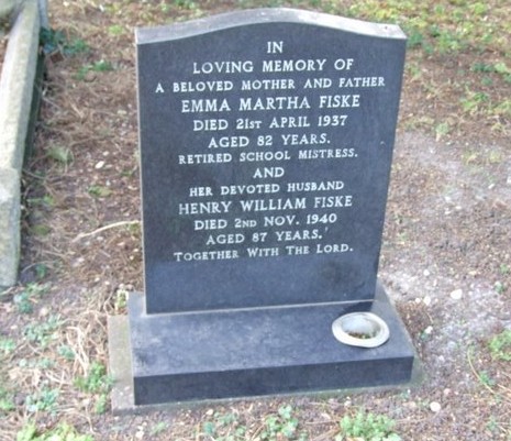
- Brian CHESTER has provided an example of his work in this FISKE monument from the graveyard:
- The parish was in the Grimsby sub-district of the Caistor Registration District.
- In an 1890 re-organization, the parish was allocated to the Grimsby sub-district of the new Grimsby Registration District.
- Check our Census Resource page for county-wide resources.
- The table below gives census piece numbers, where known:
| Census Year | Piece No. |
|---|---|
| 1841 | H.O. 107 / 631 |
| 1851 | H.O. 107 / 2114 |
| 1861 | R.G. 9 / 2391 |
| 1871 | R.G. 10 / 3416 |
| 1891 | R.G. 12 / 2620 |
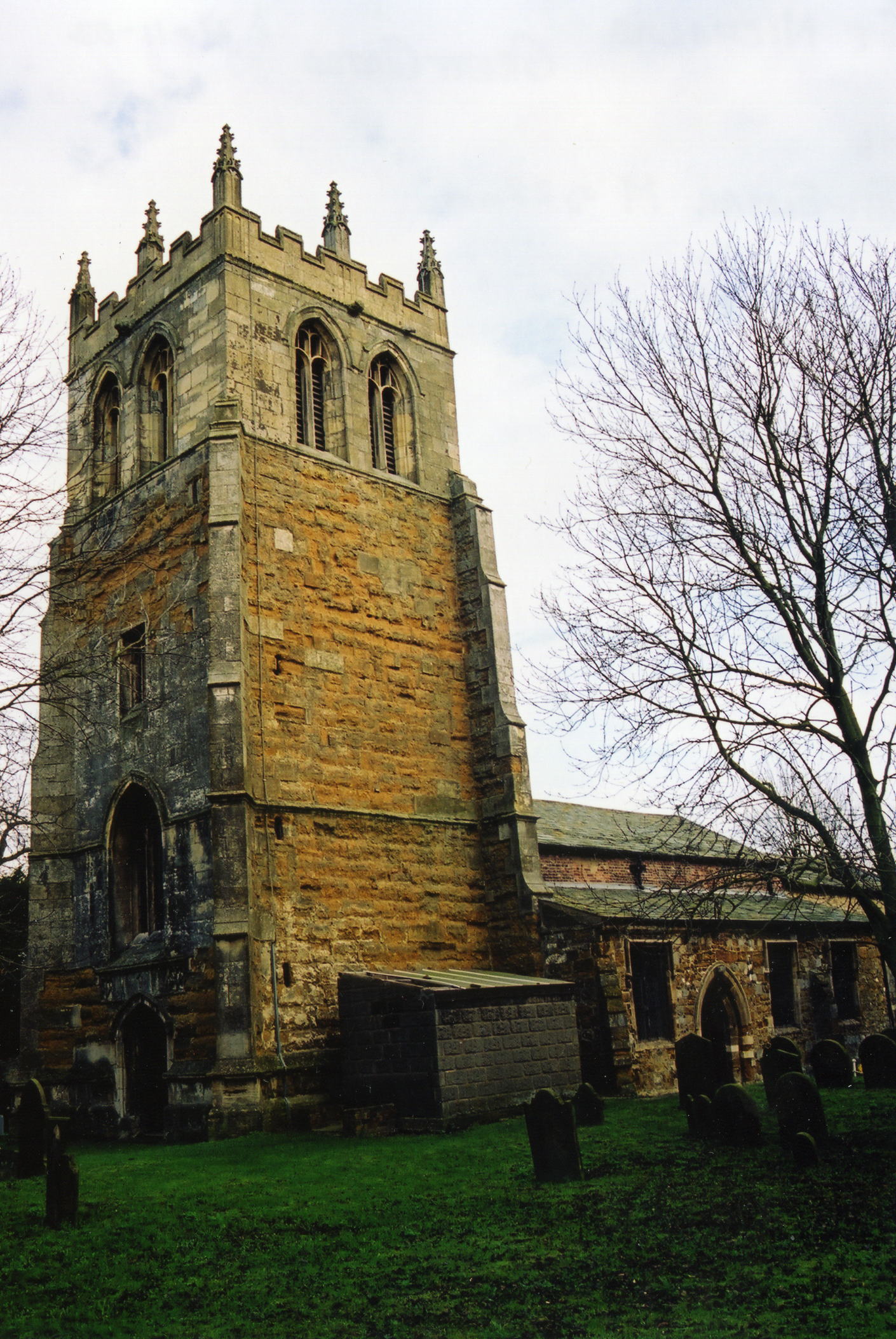
- The Anglican parish church is dedicated to Saint Nicholas (the spelling is often given as "Nicolas").
- The church tower dates from the 15th century.
- The church chancel was restored in 1865.
- The church seats 200.
- There is a photograph of the Anglican parish church on the Wendy PARKINSON Church Photos web site.
- David WRIGHT has a photograph of the church tower on Geo-graph, taken in April, 2006.
- Here is a photo of St. Nicholas Church, taken by Ron COLE (who retains the copyright):
- The Anglican parish register dates from the year 1653.
- The LFHS has published several marriage indexes and a burial index for the Grimsby and Cleethorpes Deanery to make your search easier.
- The Wesleyan Methodists formed a group here in 1759 with William BUTTRES as leader. John BAGLEY took over in 1849. A 99-year land lease by the Lord of the Manor allowed the Wesleyans to build their chapel in 1881. It opened in August of that year.
- The Primitive Methodists built their chapel in 1895. Check our Non-Conformist Church Records page for additional resources.
- Jonathan THACKER has a photograph of one of the Methodist Chapels on Geo-graph, taken in July, 2011.
- Check our Church Records page for county-wide resources.
- The parish was in the Grimsby sub-district of the Caistor Registration District.
- In an 1890 re-organization, the parish was allocated to the Grimsby sub-district of the new Grimsby Registration District.
- Check our Civil Registration page for sources and background on Civil Registration which began in July, 1837.
This parish and small village are in the north of Lincolnshire, 4 miles from Great Grimsby and 157 miles north of London. The parish borders on the River Humber to the northeast and a stream on the south and south-east called the Freshney. The parish covers about 2,300 acres.
If you are planning a visit:
- Passenger rail service came to Great Coates in 1848.
- See our touring page for visitor services.
- David NOCHOLSON provides a report on his ancestors' emigration from Great Coates to Canada. The format is PDF.
- Ask for a calculation of the distance from Great Coates to another place.
- In the early 1900s, two-fifths of the parish land was pasturage.
- Ben BROOKSBANK has a photograph of the Great Coates station on Geo-graph, taken in 1997.
- Grimsby housing and manufacturing development spilled over into Great Coates after World War Two, making it a suburb of the larger town.
/li> - Great Coates usually has an annual Scarecrow Weekend in June. Visitors are welcome.
- See our Maps page for additional resources.
You can see maps centred on OS grid reference TA238103 (Lat/Lon: 53.574977, -0.132179), Great Coates which are provided by:
- OpenStreetMap
- Google Maps
- StreetMap (Current Ordnance Survey maps)
- Bing (was Multimap)
- Old Maps Online
- National Library of Scotland (Old Ordnance Survey maps)
- Vision of Britain (Click "Historical units & statistics" for administrative areas.)
- English Jurisdictions in 1851 (Unfortunately the LDS have removed the facility to enable us to specify a starting location, you will need to search yourself on their map.)
- Magic (Geographic information) (Click + on map if it doesn't show)
- GeoHack (Links to on-line maps and location specific services.)
- All places within the same township/parish shown on an Openstreetmap map.
- Nearby townships/parishes shown on an Openstreetmap map.
- Nearby places shown on an Openstreetmap map.
Ian S. has a photograph of the War Memorial on Geo-graph, taken in March, 2020. The memorial is mounted on a wall at the Great Coates Village Nursery School. This memorial was unveiled in June 1920 and rededicated in November 1991.
There is also a WWI Memorial in the church which is a brass stand surmounted by a brass lectern in the shape of an eagle with its wings outstretched.
The brass WWI Memorial in the church has the following names (All deceased in WWI):
- Collingwood, W.
- Hinch, T.
- Mackenzie, A. H.
- Manship, A. H.
- Ornby, C.
- Robinson, C.
The War Memorial at the Nursery School is reported by the IWM to have 64 names on it, but only 57 are recorded. The names are:
- Adams, C. B.
- Adams, E.
- Adams, R. A.
- Atkins, W.
- Beacock, H.
- Bolton, C.
- Boocock, J. C.
- Bories, F. W.
- Borrell, H.
- Brocklebank, F.
- Brown, J. R.
- Carbutt, C. W.
- Clemes, F.
- Clift, J. H.
- Collingwood, W.
- Crawford, C. H.
- Cruby, R.
- Dobbs, W.
- Earoley, E.
- Farmery, W.
- Fenwick, W.
- Fowler, R.
- Franklin, H. N.
- Harrison, C.
- Harrison, T.
- Hatcliffe, F.
- Hinch, T.
- Hollingsworth, H.
- Hollingsworth, R.
- Kendall, C.
- Kirton, J. W.
- Lawson, A.
- Leaver, S.
- Mackenzie, A. S.
- Manship, A. H.
- Maskell, T.
- Moore, C.
- Pratt, W. P.
- Proctor, J.
- Quirk, D.
- Quirk, R. A.
- Raithby, J.
- Raithby, T.
- Richardson, W. B.
- Robinson, C.
- Rodham, R.
- Sarcent, C.
- Shreeve, E.
- Skells, R.
- Smith, E.
- Smith, F. H.
- Smith, W. L. W.
- Stephens, J. R M.
- Stockoale, H.
- Swain, H.
- Waddingham, E.
- Waumsley, A. W.
The Great Coates Village Council publishes a parish magazine about 4 times per year, Recent copies are online at the council site, older issues may be found at the Grimsby Library.
- This place was an ancient parish in Lincoln county and became a modern Civil Parish when those were established.
- The parish was in the ancient Bradley Haverstoe Wapentake in the Central Lindsey district in the parts of Lindsey.
- Kelly's 1900 Directory of Lincolnshire, as well as the 1913 edition, places the parish, perhaps erroneously, in the North Lindsey division of the county.
- In April, 1968, this Civil Parish was abolished and most of the land amalgamated into Healing Civil Parish.
- A few years later, the parish was reconstituted as a Civil Parish.
- You may contact the Great Coates Village Council regarding civic or political issues, but they will NOT do family history lookups for you.
- District governance is provided by the North-East Lincolnshire Council.
- Bastardy cases would be heard in the Grimsby petty session courts.
- After the 1834 Poor Law Amendment Act, this parish became part of the Caistor Poor Law Union.
- In an 1890 district re-organization, this parish was transferred to the new Grimsby Poor Law Union.
- A National School was built here in 1872 to hold 50 children.
- For more on researching school records, see our Schools Research page.