Hide
--- TEST SYSTEM --- TEST SYSTEM --- TEST SYSTEM ---
Hide
Grasby
hide
Hide
hide
Hide
hide


Hide
Hide
Grasby, par. and vil., N. Lincolnshire, 3 miles NW. of Caistor, 1,720 ac., pop. 411; P.O.
From: John BARTHOLOMEW's "Gazetteer of the British Isles (1887)"
Hide
The parish had a Reading Room in Grasby village. David WRIGHT has a photograph of the Reading Room cottage on Geo-graph, taken in June, 2006.
The nearby Caistor Library is an excellent resource with a Local History section and a Family History section.
In addition to the churchyard cemetery, the parish has a civic cemetery located in Front Street and managed by the Parish Council, with the earliest stone dated 1896.
Peter WOOD also has a photograph of All Saints churchyard on Geo-graph, taken on a wet day in April, 2018.
- The parish was in the Caistor sub-district of the Caistor Registration District.
- Check our Census Resource page for county-wide resources.
- The table below gives census piece numbers, where known:
| Census Year | Piece No. |
|---|---|
| 1841 | H.O. 107 / 635 |
| 1851 | H.O. 107 / 2114 |
| 1861 | R.G. 9 / 2392 |
| 1871 | R.G. 10 / 3421 |
| 1891 | R.G. 12 / 2621 |
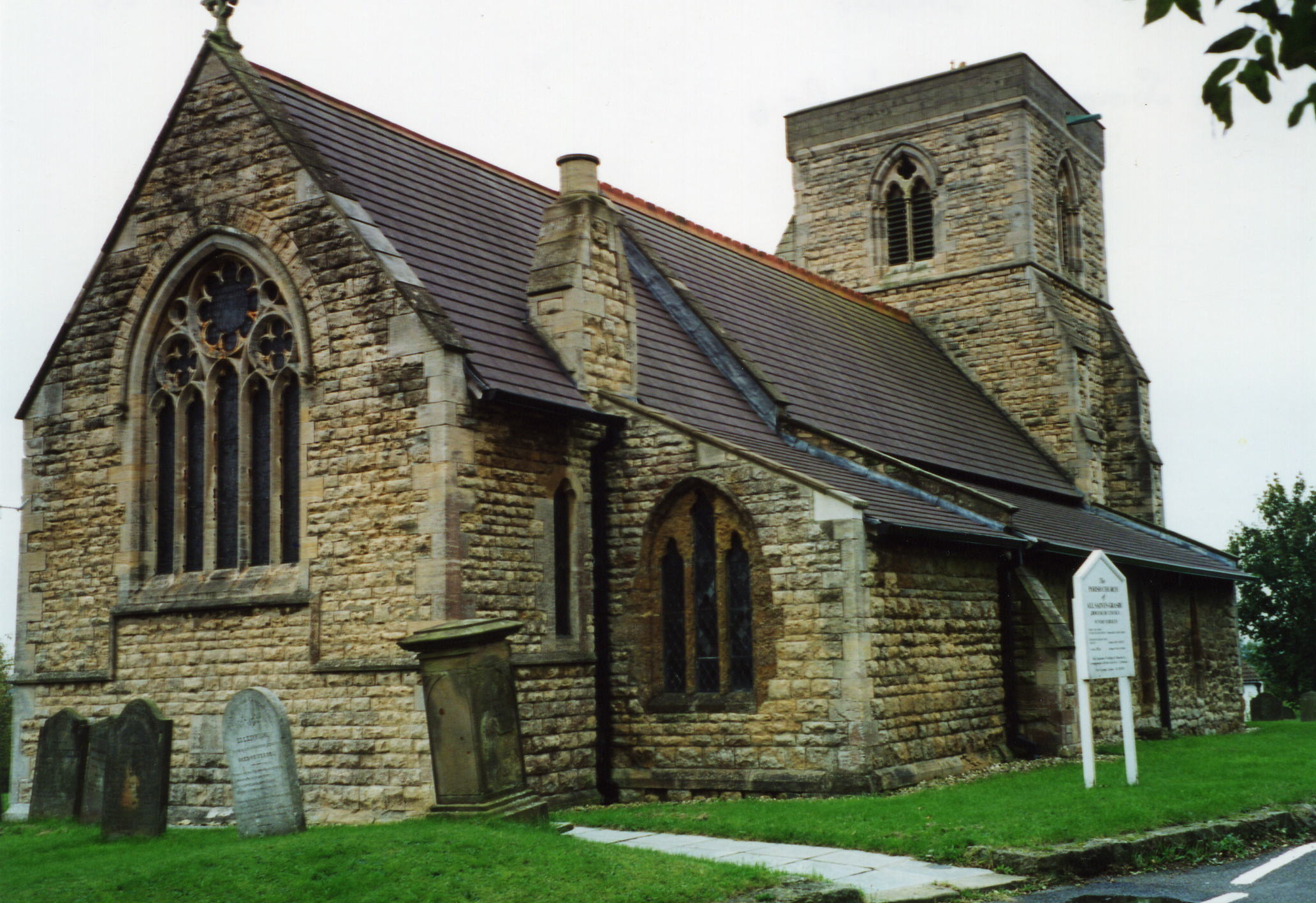
- The Anglican parish church is dedicated to All Saints.
- The Anglican parish church dates back to the 13th century, accounting for its Gothic Style. One of the church bells dates to 1500.
- The church was rebuilt in 1869.
- The church steeple was taken off the church tower in the 1800s because it was unsafe.
- The church spire was still considered unsafe around 1948 and it was taken down and a new top put in place.
- The church seats about 156 people.
- A photograph of All Saints church is at the Wendy PARKINSON English Church Photographs site.
- David HITCHBORNE has a photograph of All Saints on Geo-graph, taken in July, 2004.
- David WRIGHT has a photograph of All Saints Church at Geo-graph, taken in 2006.
- Paul HARROP also has a photograph of All Saints tower on Geo-graph, taken in June, 2016.
- Here is a photo of All Saints' Church, taken by Ron COLE (who retains the copyright):
- The Anglican parish register dates from 1653 for baptisms and burials, from 1754 for marriages.
- We have a handful of register entries from the Anglican Parish Church. Your additions and corrections are welcome.
- The LFHS has published several marriage indexes and a burial index for the Westwold Deanery to make your search easier.
- The Wesleyan Methodists built a chapel here in 1840. The Wesleyan chapel was demolished around 2000.
- The Primitive Methodists built theirs in 1841. The Primitive Methodists rebuilt their chapel in 1893. The Primitive Methodist chapel is now a private residence. For more information on these chapels, see our Non-Conformist Church Records page.
- David WRIGHT has a photograph of the former Primitive Methodist Chapel on Geo-graph, taken in June, 2006.
- Chris MORGAN also has a photograph of the former Primitive Methodist Chapel on Geo-graph, taken in February, 2018.
- Check our Church Records page for county-wide resources.
- The parish was in the Caistor sub-district of the Caistor Registration District.
- Check our Civil Registration page for sources and background on Civil Registration which began in July, 1837.
This parish and village in the northern Lincolnshire Wolds, is 3 miles north-west of Caistor on the road to Brigg. The parish itself is a long, thin format, running roughly north and south, and just west of Clixby parish.
If you are planning a visit:
- The village is just south of the A1084 trunk road between Brigg and Caistor. The road drops down into the village, but there are still great views of the countryside.
- The old Viking Way passes through the heart of the village.
- There is a lot of active use of the Village Hall.
- See our touring page for visitor services.
The National Gazetteer of Great Britain and Ireland - 1868
- Ask for a calculation of the distance from Grasby to another place.
- Charles TENNYSON, brother of Lord Alfred, lived here and was vicar of the church for about 40 years. He came to the parish in 1835, a few years after changing his name to Charles Tennyson TURNER on succeeding to the estate of his great-uncle Samuel TURNER of Caistor. His wife's sister was the wife of Alfred TENNYSON.
- There is a history of Grasby at the Grasby Parish Council site. It appears to be mostly excerpts from historical directories.
- Clint MANN has a photograph of the Cross Keys Pub. on Geo-graph, taken in March, 1979. The pub is still operating.
- Steve FAREHAM also has a photograph of the Cross Keys Pub. on Geo-graph, taken in February, 2014.
- In 1900 and again in 1913, the proprietor of the Cross Keys Pub is given as George ROSKILLY.
- The national grid reference is TA 0804.
- You'll want an Ordnance Survey Explorer map, which has a scale of 2.5 inches to the mile.
- See our Maps page for additional resources.
You can see maps centred on OS grid reference TA087049 (Lat/Lon: 53.529391, -0.361433), Grasby which are provided by:
- OpenStreetMap
- Google Maps
- StreetMap (Current Ordnance Survey maps)
- Bing (was Multimap)
- Old Maps Online
- National Library of Scotland (Old Ordnance Survey maps)
- Vision of Britain (Click "Historical units & statistics" for administrative areas.)
- English Jurisdictions in 1851 (Unfortunately the LDS have removed the facility to enable us to specify a starting location, you will need to search yourself on their map.)
- Magic (Geographic information) (Click + on map if it doesn't show)
- GeoHack (Links to on-line maps and location specific services.)
- All places within the same township/parish shown on an Openstreetmap map.
- Nearby townships/parishes shown on an Openstreetmap map.
- Nearby places shown on an Openstreetmap map.
For a list of names on the war memorial plaques, see the Memorials site.
We also have Ifor BARTON's Roll of Honour as a Portable Document File you can download and print out.
Also, use the Roll-of-Honour website to check out relatives.
- The name is often found in older records with the additional S as in "GRASS-by".
- This place was an ancient parish in county Lincoln and became a modern Civil Parish when those were established.
- The parish was in the ancient Yarborough Wapentake in the West Lindsey district in the parts of Lindsey.
- Kelly's 1913 Directory of Lincolnshire places the parish, perhaps erroneously, in the North Lindsey division of Lindsey.
- In April, 1936, this Civil Parish was enlarged by 1,261 acres when Clixby Civil Parish was abolished.
- You can contact the local Grasby Parish Council regarding civic or political issues. They are NOT staffed to assist you with family history questions.
- Today's district governance is provided by the West Lindsey District Council.
- Bastardy cases would be heard in the Caistor petty session hearings on the fourth Wednesday of each month and nearly every Saturday.
- In 1720, Samuel FAULDIN left the rent charge from land in the parish to the poor. In 1841 this was 40 shillings per year.
- As a result of the 1834 Poor Law Amendment Act, this parish became part of the Caistor Poor Law Union.
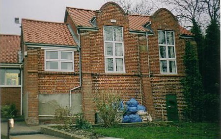
- Charles Tennyson TURNER rebuilt the village school in 1855.
- For more on researching school records, see our Schools Research page.
- Tim HEATON has a photograph of Grasby School at Geo-graph, taken in June, 2008.
- Jonathan THACKER also has a photograph of the Grasby All Saints Church of England Primary School on Geo-graph, taken in June, 2011.
- Here is a photo of Grasby School, taken by Debbie SHEARWOOD (who retains the copyright):