
Hide
--- TEST SYSTEM --- TEST SYSTEM --- TEST SYSTEM ---
Hide
Elsham
hide
Hide
hide
Hide
hide
Hide
Hide
hide
Hide
Elsham, par. and ry. sta., N. Lincolnshire, on the Wolds, 4 miles NE. of Brigg, 4,100 ac., pop. 502; P.O.; contains Elsham Hall.
From John BARTHOLOMEW's Gazetteer of the British Isles (1887)
Hide
The Brigg Library is an excellent resource with a Local History section.
- The parish was in the Brigg sub-district of the Glanford Brigg Registration District.
- Check our Census Resource page for county-wide resources.
- The table below gives census piece numbers, where known:
| Census Year | Piece No. |
|---|---|
| 1841 | H.O. 107 / 632 |
| 1861 | R.G. 9 / 2399 |
| 1871 | R.G. 10 / 3430 |
| 1891 | R.G. 12 / 2626 |
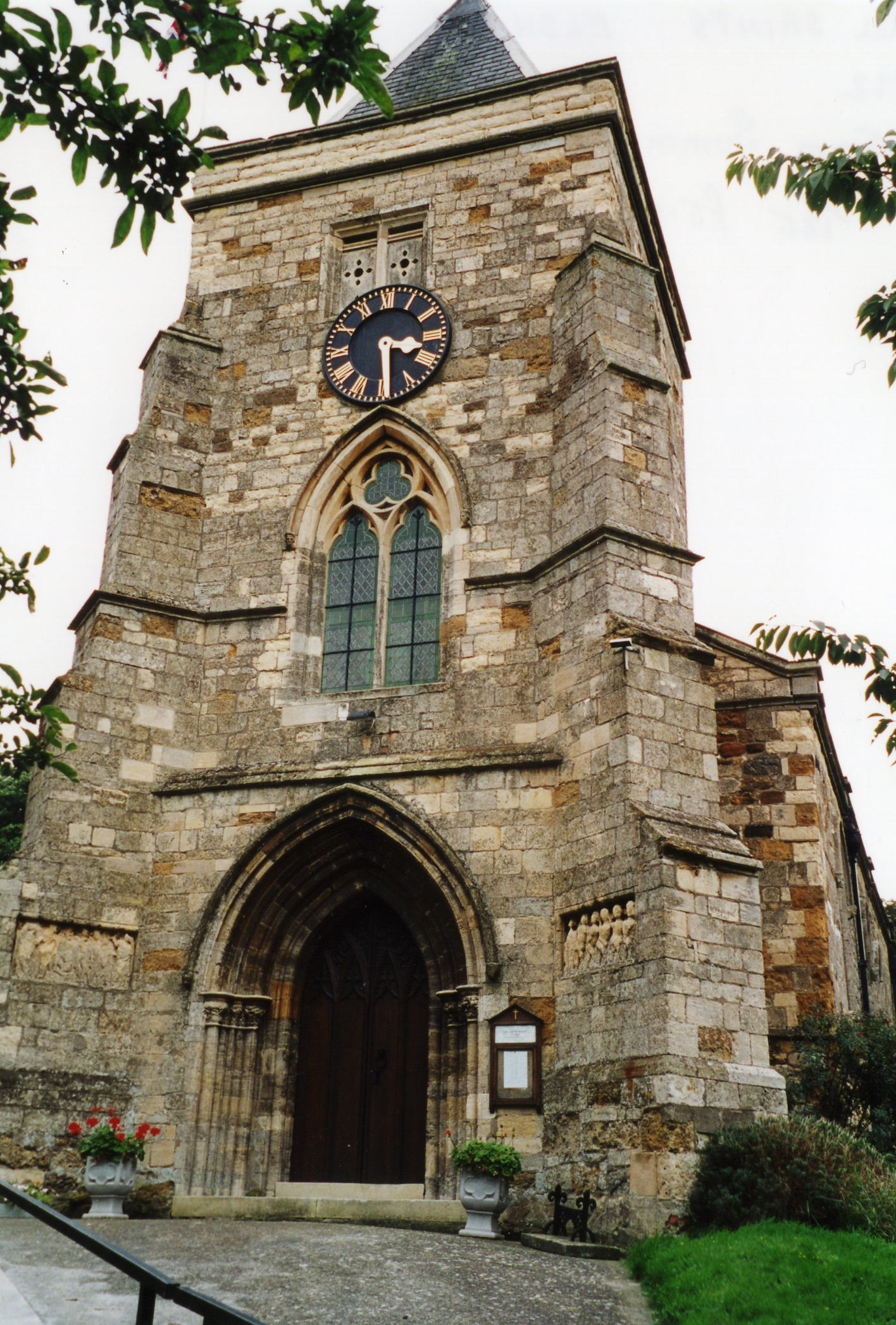
- The Anglican parish church is dedicated to All Saints.
- The church is built of stone in the Early English style, but a date is uncertain.
- The church was restored in 1873-74.
- The church seats about 219 people.
- There is a photograph of the Anglican parish church on the Wendy PARKINSON Church Photos web site.
- Richard CROFT has a photograph of the church tower on Geo-graph, taken in 2008.
- Here is a photo of All Saints Church, taken by Ron COLE (who retains the copyright):
- The Anglican parish register dates from 1566.
- We have the beginnings of an extract from the parish register. Your additions to this Parish Register Extract text file will be appreciated. Please contact the site coordinator (below).
- The Lincolnshire FHS has published several marriage indexes and a burial index for the Yarborough Deanery to make your search easier.
- A small Wesleyan chapel was built in the village to sit 100 people. For information and assistance in researching this chaple, see our non-conformist religions page.
- Check our Church Records page for county-wide resources.
- The parish was in the Brigg sub-district of the Glanford Brigg Registration District.
- Check our Civil Registration page for sources and background on Civil Registration which began in July, 1837.
Elsham is a parish and a village in the north of Lincolnshire 163 miles north of London and about 4 miles northeast of Glanford Brigg. The parish covers just over 4,100 acres.
If you are planning a visit:
- Stop by the Village Hall and ask for a schedule of upcoming events. The Hall is photographed by David WRIGHT in 2005.
- See our touring page for visitor services.
The National Gazetteer of Great Britain and Ireland - 1868
"ELSHAM, a parish in the N. division of the hundred of Yarborough, parts of Lindsey, county Lincoln, 2 miles N. of the Barnetby station on the Manchester and Lincolnshire railway, and 4 N.W. of Brigg, its post town. It is situated on the Wolds. A hospital for Austin Canons was founded here in the 12th century by Beatrix de Amundeville, and dedicated to SS. Mary and Edmund. Its revenue at the Dissolution amounted to £83 17s. led. The living is a vicarage in the diocese of Lincoln, value £46, The church, dedicated to All Saints, is a neat structure, with handsome western porch. The Wesleyans have a place of worship. The parochial charities produce about £10 per annum. Elsham Hall is the principal residence. T. G. Corbett, Esq., is lord of the manor."
- Ask for a calculation of the distance from Elsham to another place.
- Elsham Hall, a fairly modern mansion of brick, stood in a park of 150 acres at one time.
- Peter CHURCH has a photograph of the Manor lake on Geo-graph, taken in 2011.
- David WRIGHT has a photograph of the Manor House in Front Street on Geo-graph, taken in April, 2009.
- See our Maps page for additional resources.
You can see maps centred on OS grid reference TA035124 (Lat/Lon: 53.597548, -0.438166), Elsham which are provided by:
- OpenStreetMap
- Google Maps
- StreetMap (Current Ordnance Survey maps)
- Bing (was Multimap)
- Old Maps Online
- National Library of Scotland (Old Ordnance Survey maps)
- Vision of Britain (Click "Historical units & statistics" for administrative areas.)
- English Jurisdictions in 1851 (Unfortunately the LDS have removed the facility to enable us to specify a starting location, you will need to search yourself on their map.)
- Magic (Geographic information) (Click + on map if it doesn't show)
- GeoHack (Links to on-line maps and location specific services.)
- All places within the same township/parish shown on an Openstreetmap map.
- Nearby townships/parishes shown on an Openstreetmap map.
- Nearby places shown on an Openstreetmap map.
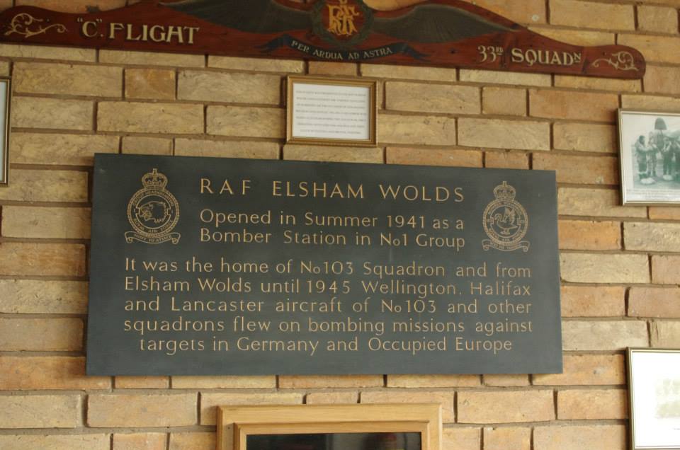
- The Royal Flying Corps opened an airfield here in December, 1916, to counter Zeppelin raids. The fields was designated as "Elsham Wolds".
- The field was closed in June, 1919.
- The field was surveyed in 1939 and deemed suitable for bomber aircraft. An important factor was the nearby railway station at Barnetby.
- The RAF re-opened the field in July, 1941. The first operational sortie took off on 24 July that year.
- The field closed again in 1947.
- The A15 trunk road now bisects the former station.
- Rita EFFNERT in Germany provides this list of attendees at an RAF Christmas dinner, 1941.
- David WRIGHT has a photograph of the War Memorial cross in the churchyard on Geo-graph, taken in 2005.
- Pat HORTON shares a photograph of the Information Sign over the doorway, taken in 2015:
For a photograph of the Elsham War Memorial and a list of the names on it, see the Roll of Honour site.
- The parish was in the ancient Yarborough Wapentake in the Glanford district in the parts of Lindsey.
- You can contact the local Elsham Parish Council regarding civic or political issues. They are NOT staffed to assist you with family history questions.
- For today's district governance, see the North Lincolnshire Council website.
- Bastardy cases would be heard in the Brigg petty session hearings.
- There was an ancient Hospital for the poor, established prior to 1166. It stood near the Hall.
- After the Poor Law Amendment Act reforms of 1834, this parish became part of the Glanford Brigg Poor Law Union.
- A Public Elementary School was built here in 1872 and enlarged in 1895 to hold up to 180 children.
- For more on researching school records, see our Schools Research page.