
Hide
--- TEST SYSTEM --- TEST SYSTEM --- TEST SYSTEM ---
Hide
Dunholme
hide
Hide
hide
Hide
hide
Hide
Hide
“DUNHOLM, a parish in the wapentake of Lawress, parts of Lindsey, in the county of Lincoln, 3 miles W. of Snelland station on the Great Northern railway, and 6 N.E. of Lincoln, its post town. The village, which is small, is situated on the road from Lincoln to Market Rasen. At the E. end of the parish is a stream which runs from the Ancholine to the river Witham. The living is a vicarage in the diocese of Lincoln, value £98, in the patronage of the bishop, who is lord of the manor. The church, dedicated to St. Chad, is an ancient structure, with embattled tower and three bells, and contains some curious monuments. The charities amount to £4 per annum. The register commences in 1582. The Wesleyans have a chapel, and there is a church school."
”
from The National Gazetteer of Great Britain and Ireland - 1868
Hide
- Ias N. has a photograph of St. Chad's Graveyard on Geo-graph, taken in May, 2018.
| St Chad, Dunholme, Church of England |
- The parish was in the North-East sub-district of the Lincoln Registration District.
- Check our Census Resource page for county-wide resources.
- The table below gives census piece numbers, where known:
Census
YearPiece No. 1841 H.O. 107 / 632 1861 R.G. 9 / 2363 1871 R.G. 10 / 3376 1891 R.G. 12 / 2596
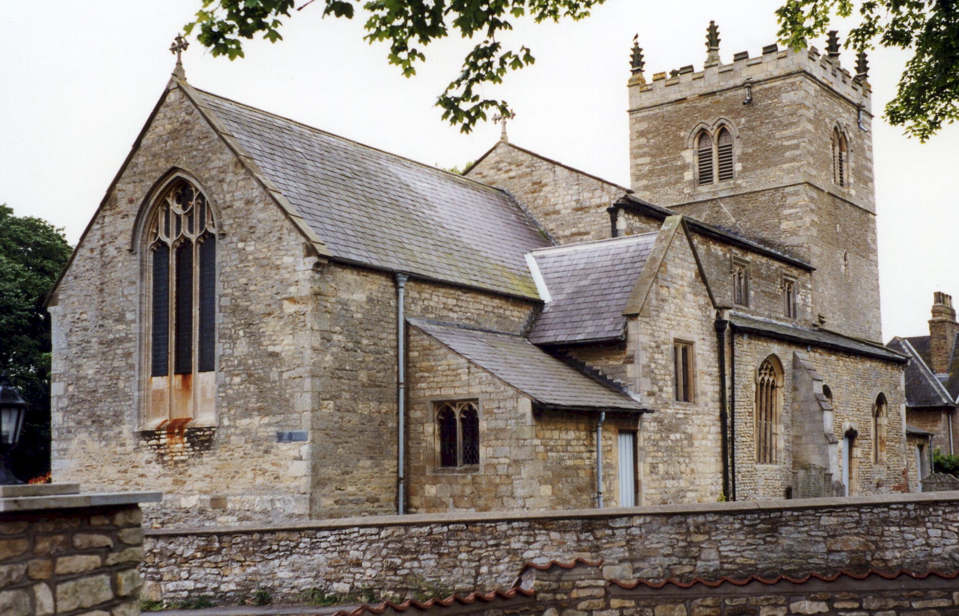
- The Anglican parish church is dedicated to Saint Chad.
- The church is in the Early English style, which implies a Saxon origin.
- The church was restored in 1856.
- The church was partially restored in 1902 when an organ chamber and vestry were added.
- The church seats 220.
- Here is a photo of Saint Chad's Church, taken by Ron COLE (who retains the copyright):
- The Anglican parish register dates from 1582.
- The Lincolnshire Archive Office has the parish register from 1581 to 1812.
- The Lincolnshire FHS has a Loan Library service which has the parish registers on microfiche for Baptisms from 1564 to 1812 and Marriages from 1564 to 1811.
- The LFHS has published several marriage indexes and a burial index for the Lawres Deanery to make your search easier.
- The United (Free) Methodists had a chapel here prior to 1913. For information and assistance in researching this chapel, see our non-conformist religions page.
- Check our Church Records page for county-wide resources.
- The parish was in the North-East sub-district of the Lincoln Registration District.
- Check our Civil Registration page for sources and background on Civil Registration which began in July, 1837.
Dunholme is both a village and a parish north-east of the city of Lincoln. Welton parish lies to the north and Scothern parish to the south. The parish covers 2,261 acres.
The large village of Dunholme almost merges with Welton village to the north. If you are planning a visit:
- Check out the village website to become familiar with the place.
- Be careful when crossing the beck that flows through the village. The ducks have the right-of-way.
- Watch for the Village Sign, here photographed by Tony HIBBERD in December, 2012.
- Take the A46 north-east out of Lincoln. It passes along the south edge of Dunholme village.
- See our touring page for more sources.
The National Gazetteer of Great Britain and Ireland - 1868
- Ask for a calculation of the distance from Dunholme to another place.
- Ian S. has a photograph of the Queen Victoria's Diamond Jubilee tablet on Geo-graph, taken in May, 2018.
- See our Maps page for additional resources.
You can see maps centred on OS grid reference TF022792 (Lat/Lon: 53.30021, -0.46752), Dunholme which are provided by:
- OpenStreetMap
- Google Maps
- StreetMap (Current Ordnance Survey maps)
- Bing (was Multimap)
- Old Maps Online
- National Library of Scotland (Old Ordnance Survey maps)
- Vision of Britain (Click "Historical units & statistics" for administrative areas.)
- English Jurisdictions in 1851 (Unfortunately the LDS have removed the facility to enable us to specify a starting location, you will need to search yourself on their map.)
- Magic (Geographic information) (Click + on map if it doesn't show)
- GeoHack (Links to on-line maps and location specific services.)
- All places within the same township/parish shown on an Openstreetmap map.
- Nearby townships/parishes shown on an Openstreetmap map.
- Nearby places shown on an Openstreetmap map.
- The RAF had a grass landing strip here in 1941 and 1942 used as an emergency strip by aircraft from RAF Scampton.
- In September, 1942, the RAF gave the airfield official designation as RAF Dunholme Lodge. By May, 1943, it was a full station under 5 Group Bomber Command.
- During World War II, over 120 Lancaster bombers from this field were lost in combat operations.
- Flight operations ceased here on 30 November 1944, mostly due to having too many airfields in the vacinity causing some confusion for aircrews. The field became a glider storage area until the end of the war.
- The RAF closed the field in 1945.
- The field re-opened in 1959 as a Bloodhound surface-to-air (SAM) missile site.
- The missile site closed in 1964.
- The war memorial is a tall stone cross on a plinth in a traffic circle in the village.
There are war memorial plaques in St. Chad's Church.
There is a list of the names from the plaques and the Roll of Honour in the church at the Roll of Honour site.
- Locals refer to the place as "Dunnam". [Jean Pryde]
- "Dunholm" is accepted as an alternate spelling of the parish name.
- This place was an ancient parish in Lincoln county and became a modern Civil Parish when those were establ;ished.
- The parish was in the ancient Lawress Wapentake in the West Liindsey district in the parts of Lindsey.
- You may contact the local Dunholme Parish Council regarding civic or political issues, but they are NOT staffed to answer family history questions.
- Today's district governance is provided by the West Lindsey District Council.
- The poor of this parish had a small distribution of £1 and 8 shillings (1900) derived from land in this parish.
- In 1616, Robert GRANTHAM left a yearly charity of £1 and coats to 10 Bedesmen in this parish and in Sudbrooke and Scothern.
- As a result of the Poor Law Reform Act of 1834, the parish became part of the Lincoln Poor Law Union.
- Bastardy cases would be heard in the Bail and Close (Lincoln) petty sessional hearings.
- The Lincolnshire Archive Office has the Croft and Hanson Charity distributions from 1943-1959.
Year Inhabitants 1801 140 1831 237 1841 310 1851 411 1871 450 1881 403 1891 336 1901 289 1911 323 1921 298 1931 394
- A Public Elementary School was built here in 1862 for 82 children.
- The Lincolnshire Archive Office has the school managers' minute book for 1903 thru 1952.
- For more on researching school records, see our Schools Research page.