
Hide
--- TEST SYSTEM --- TEST SYSTEM --- TEST SYSTEM ---
Hide
Dalderby
hide
Hide
hide
Hide
hide


Hide
Hide
hide
Hide
“DALDERBY, a parish in the S. division of the wapentake of Gartree, parts of Lindsey, in the county of Lincoln, 2¼, miles S. of Horncastle, its post town. It is situated on the Horncastle canal and the river Bain. There is no village, only five cottages. The living is a rectory in the diocese of Lincoln, annexed to the rectory of Scrivelsby. The church; which is now in ruins, was dedicated to St., Martin."
”
from The National Gazetteer of Great Britain and Ireland - 1868
Hide
- The parish was in the Tetford sub-district of the Horncastle Registration District.
- Check our Census Resource page for county-wide resources.
- The table below gives census piece numbers, where known:
| Census Year | Piece No. |
|---|---|
| 1841 | H.O. 107 / 632 |
| 1851 | H.O. 107 / 2107 |
| 1861 | R.G. 9 / 2369 & 2371 |
| 1871 | R.G. 10 / 3383 |
| 1891 | R.G. 12 / 2599 |
- The Anglican parish church was dedicated to Saint Martin.
- The Church of St. Martin went into decay before 1741, so people of this parish attended services in Scrivelsby or other nearby parishes. The site of the old church and the graveyard could still be traced in 1900.
- The Anglican parish register dates from 1690 to 1744.
- The LFHS has published several marriage and burial indexes for the Horncastle Deanery to make your search easier.
- Check our Church Records page for county-wide resources.
- The parish was in the Tetford sub-district of the Horncastle Registration District.
- Check our Civil Registration page for sources and background on Civil Registration which started in July, 1837.
Dalderby is both a small village and a small parish in the vale of the River Bain, three miles south of Horncastle. Thornton parish lies to the north and Scrivelsby parish to the east. The parish covers a mere 440 acres.
Dalderby village sits on the east bank of the River Bain. If you are planning a visit:
- Take the A153 south out of Horncastle. It passes through the center of Dalderby.
- While you are there, hike along the Spa Trail for a nice walk. Photo taken in August, 2011, by Richard CROFT.
- See our touring page for visitor services.
The National Gazetteer of Great Britain and Ireland - 1868
- Ask for a calculation of the distance from Dalderby to another place.
- In 1842, the principal landowner was Sir Henry DYMOKE, baronet and lord of the manor.
- In 1882, the principal landowner was the estate of Sir Henry DYMOKE.
- Tea Pot Hall was never a Manor House. It was a tiny thatched cottage in Dalderby parish - between Dalderby and Scrivelsby. There is a picture of it in Lincolnshire Life magazine, July 1972 - where is says it was burnt down in 1945.
- The national grid reference is TF 2466.
- You'll want an Ordnance Survey Explorer 273 map, which has a scale of 2.5 inches to the mile.
- See our Maps page for additional resources.
You can see maps centred on OS grid reference TF242662 (Lat/Lon: 53.178417, -0.143067), Dalderby which are provided by:
- OpenStreetMap
- Google Maps
- StreetMap (Current Ordnance Survey maps)
- Bing (was Multimap)
- Old Maps Online
- National Library of Scotland (Old Ordnance Survey maps)
- Vision of Britain (Click "Historical units & statistics" for administrative areas.)
- English Jurisdictions in 1851 (Unfortunately the LDS have removed the facility to enable us to specify a starting location, you will need to search yourself on their map.)
- Magic (Geographic information) (Click + on map if it doesn't show)
- GeoHack (Links to on-line maps and location specific services.)
- All places within the same township/parish shown on an Openstreetmap map.
- Nearby townships/parishes shown on an Openstreetmap map.
- Nearby places shown on an Openstreetmap map.
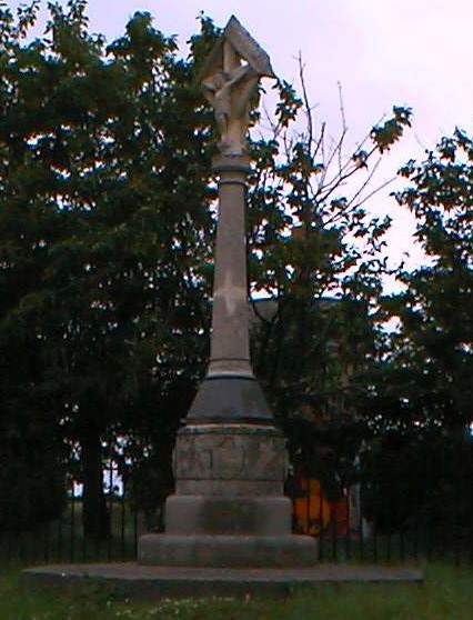
J. THOMAS has a photograph of the War Memorial on Geo-graph, taken in September, 2013.
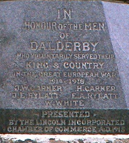
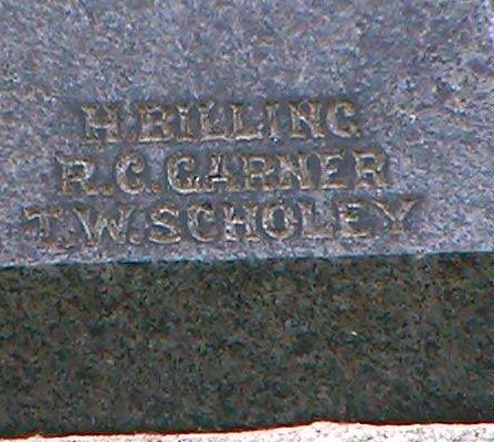
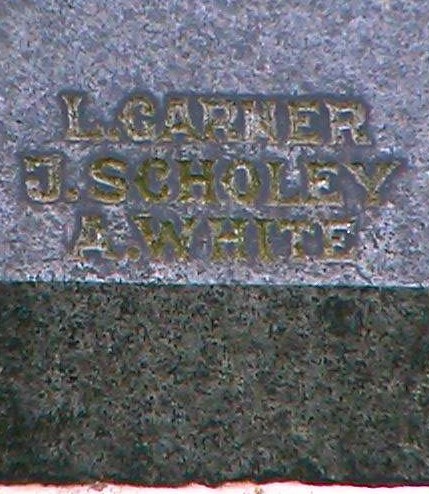
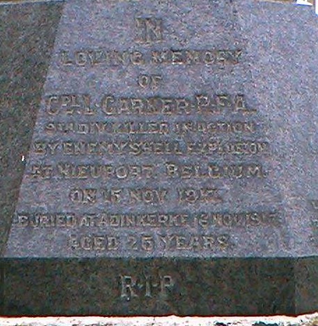
Margaret BRINN reports: "The Dalderby Cross itself carries the names of 11 men, from five local families in the village who fought in the war; all but one returned. The Cross was erected to recognise the Lincolnshire villages which sent the largest percentage of its menfolk to the front line prior to May 1st 1915. The names of the men who went were H BILLING, JH GARNER, L GARNER, H GARNER, RC GARNER, JE RYLATT, FA RYLATT, J SCHOLEY, TW SCHOLEY, W WHITE and A WHITE."
John Emerson, who retains the copyright, provides these photographs of the war memorial at Dalderby:
- White's 1842 Directory lists the following names in the parish: Walls JEFFERYS, John KNOWLES, George RAWSON and Stphn. SEMPER.
- White's 1872 Directory lists the following names in the parish: Thomas GAUNT, John JEFFERY, Edward JOBSON and the Rev. Samuel LODGE.
- White's 1882 Directory lists the following names in the parish: John JEFFERY, Edward JOBSON and Thomas WELCH.
- This place was an ancient parish in Lincoln county and became a modern Civil Parish when those were established.
- The parish was in the Southern division of the ancient Gartree Wapentake in the East Lindsey district in the parts of Lindsey.
- Kelly's 1900 Directory of Lincolnshire places the parish, perhaps erroneously, in the South Lindsey district of the county, as does the 1913 edition.
- In April, 1936, this Civil Parish was abolished and the land was split up and attached to other nearby parishes.
- For today's district governance, see the East Lindsey District Council.
- Bastardy cases would be heard in the Horncastle petty session hearings.
- As a result of the 1834 Poor Law Amendment Act, the parish became part of the Horncastle Poor Law Union.
- The children of this parish attended school in nearby Roughton, across the river.
- For more on researching school records, see our Schools Research page.