
Hide
--- TEST SYSTEM --- TEST SYSTEM --- TEST SYSTEM ---
Hide
Coates (by Stow)
hide
Hide
hide
Hide
hide


Hide
Hide
hide
Hide
Coates, par., N. Lincolnshire, 7 miles SE. of Gainsborough, 950 ac., pop. 51.
from: John BARTHOLOMEW's "Gazetteer of the British Isles (1887)"
Hide
The Gainsborough Library is an excellent resource with both a Local History section and a Family History section.
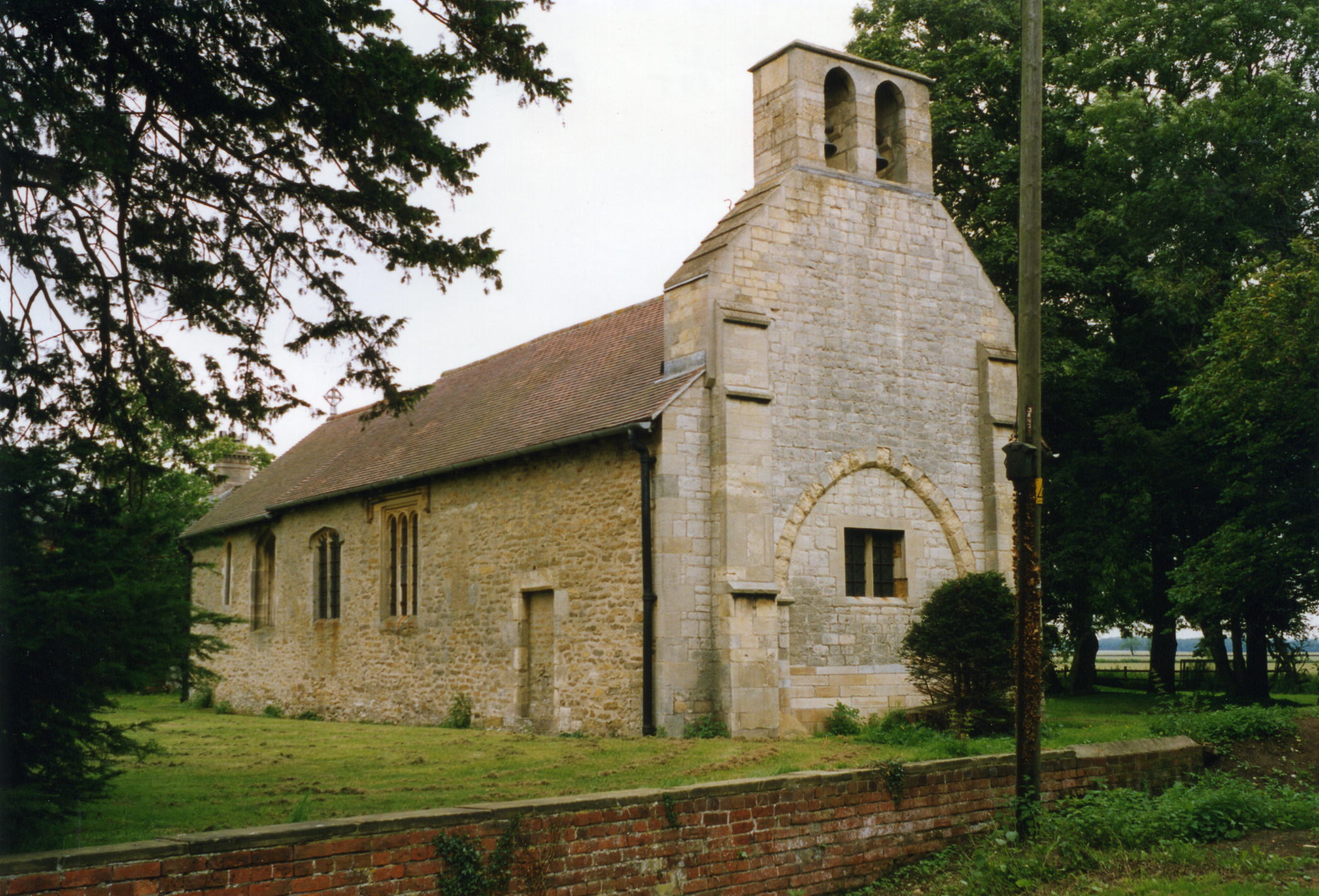
| St Edith, Coates, Church of England |
- The parish was in the Willingham sub-district of the Gainsborough Registration District.
- After a district re-organization in 1890, the parish was in the Marton subdistrict of the Gainsborough Registration District.
- The North Lincolnshire Library holds a copy of the parish census returns for 1841 through 1901.
- Check our Census Resource page for county-wide resources.
- The table below gives census piece numbers, where known:
| Census Year | Piece No. |
|---|---|
| 1841 | H.O. 107 / 631 |
| 1851 | H.O. 107 / 2120 |
| 1861 | R.G. 9 / 2410 |
| 1871 | R.G. 10 / 3447 |
| 1891 | R.G. 12 / 2636 |
| St Edith, Coates, Church of England |
- The Anglican parish church is dedicated to Saint Edith.
- The Church of St. Edith is a small structure of Norman origin, having brass plates and other memorials of the BUTLER family and a bust of Brian COOKE of Doncaster, who died in 1653 at age 80.
- The church was restored in 1883 and seats about 80.
- The church now stands in a farm yard.
- The church is listed in "England's Thousand Best Churches" by Simon JENKINS, publ. by Penguin.
- The church has a website, but most of the web pages are awaiting development.
- There is a photograph of the Church of St. Edith on the Wendy PARKINSON Church Photos web site.
- Richard CROFT has a photograph of St. Edith's Church on Geo-graph, taken in 2005.
- David HITCHBORNE has a photograph of the church interior on Geo-graph, taken in 2004.
- Here is a photo of the church, taken by Ron COLE (who retains the copyright):
- Parish registers exist from 1661, but the Bishop's transcripts go back to 1601.
- The North Lincolnshire Library holds a copy of the parish register entries for baptisms 1663 - 1812, burials 1669 - 1793 and marriages 1662 - 1956.
- The Lincolnshire FHS has published several marriage and burial indexes for the Corringham Deanery to make your search easier.
- Check our Church Records page for county-wide resources.
- The parish was in the Willingham sub-district of the Gainsborough Registration District.
- After a district re-organization in 1890, the parish was in the Marton subdistrict of the Gainsborough Registration District.
- Check our Civil Registration page for sources and background on Civil Registration which began in July, 1837.
Coates (Coates by Stow) is both a parish and a cluster of buildings about 9 miles south-east of Gainsborough, 9 miles north of the city of Lincoln and about 151 miles north of London. The parish itself is lies between two branches of the River Till, bordered on the north by Fillingham parish, on the west by Stow parish, and to the south by Ingham parish. The parish covered about 950 acres in 1842, later increased to just over 1,000 acres. The parish includes the hamlet of Bransby.
Coates was, in 1842, a single farm in the western Wolds. If you are planning a visit:
- Take the A1500 trunk road east out of Marton. Pass thru Stow and when you cross the first branch of the River Till, you are in Coates parish.
- Visit our touring page for more sources.
The National Gazetteer of Great Britain and Ireland - 1868
- Ask for a calculation of the distance from Coates (by Stow) to another place.
- In 1842, Mr. George MOTLEY occupied the farm, residing in the old hall which was formerly the seat of the BUTLER family. Mr. MOTLEY owned about 200 acres and the rest of the parish belonged to the executors of the late Sir John RAMSDEN.
- In 1872, Mr. Oldham WALKER occupied the farm, but George MOTLEY still owned 200 acres. The rest of the parish was owned by Sir John William RAMSDEN, baronet.
- The old Coates Hall was torn down between 1842 and 1872 and New Hall was erected on the same site to replace it.
- See our Maps page for additional resources.
You can see maps centred on OS grid reference SK913833 (Lat/Lon: 53.338612, -0.629654), Coates (by Stow) which are provided by:
- OpenStreetMap
- Google Maps
- StreetMap (Current Ordnance Survey maps)
- Bing (was Multimap)
- Old Maps Online
- National Library of Scotland (Old Ordnance Survey maps)
- Vision of Britain (Click "Historical units & statistics" for administrative areas.)
- English Jurisdictions in 1851 (Unfortunately the LDS have removed the facility to enable us to specify a starting location, you will need to search yourself on their map.)
- Magic (Geographic information) (Click + on map if it doesn't show)
- GeoHack (Links to on-line maps and location specific services.)
- All places within the same township/parish shown on an Openstreetmap map.
- Nearby townships/parishes shown on an Openstreetmap map.
- Nearby places shown on an Openstreetmap map.
- The name Coates comes from the Old English cot for "the cottages or huts".
Anthony D. MILLS, "A Dictionary of English Place-Names," Oxford University Press, 1991.
- White's 1872 Directory lists the following names in the parish: Oldham WALKER, farmer; George DAVISON and William WILKINSON.
- Kelly's 1900 Directory lists the following names in the parish: William BELL, Alfred DAVISON and John PRESSWOOD.
- Kelly's 1913 Directory lists the following names in the parish: John Tom GLEW and Thomas PRESSWOOD.
- This place was an ancient parish in Lincoln county and became a modern Civil Parish when those were established.
- The parish was in the ancient Aslacoe Wapentake in the West Lindsey district in the parts of Lindsey.
- In April, 1936, this Civil Parish was abolished and all 1,034 acres amalgamated into Stow Civil Parish.
- Today's district governance is provided by the West Lindsey District Council.
- Bastardy cases would be heard in the Lincoln petty session hearings.
- After the Poor Law Amendment Act reforms of 1834, the parish became part of the Gainsborough Union Workhouse.
- The parish was included in the Stow-by-Gainsborough School District, formed 18 January 1876. The children of the parish attended school at Sturton.
- For more on researching school records, see our Schools Research page.