
Hide
--- TEST SYSTEM --- TEST SYSTEM --- TEST SYSTEM ---
Hide
Bassingthorpe
hide
Hide
hide
Hide
hide


Hide
Hide
hide
Hide
“BASSINGTHORPE, (or Basingthorpe), a parish in the wapentake of Beltisloe, parts of Kesteven, in the county of Lincoln, 3 miles to the N.W. of Corby. Westby is a hamlet of this parish The living is a vicarage* in the diocese of Lincoln, value £191, in the patronage of Earl Dysart. The church is dedicated to St. Thomas-a-Becket.
"WESTBURY, a hamlet in the parish of Bassingthorpe, wapentake of Beltisloe, parts of Kesteven, county Lincoln, 3½ miles N.W. of Corby. The Roman Catholics have a chapel."
”
from The National Gazetteer of Great Britain and Ireland - 1868
Hide
The Library at Grantham will prove useful in your research.
J. HANNAN-BRIGGS has a photograph of St. Thomas' churchyard on Geo-graph, taken in March, 2012.
- The parish was in the Colsterworth sub-district of the Grantham Registration District.
- Starting in 1891 the parish was in the "Grantham South" sub-district of the Grantham Registration District.
- Check our Census Resource page for county-wide resources.
- The table below gives census piece numbers, where known:
| Census Year | Piece No. |
|---|---|
| 1841 | H.O. 107 / 615 |
| 1851 | H.O. 107 / 2102 |
| 1861 | R.G. 9 / 2347 |
| 1871 | R.G. 10 / 3355 |
| 1891 | R.G. 12 / 2582 |
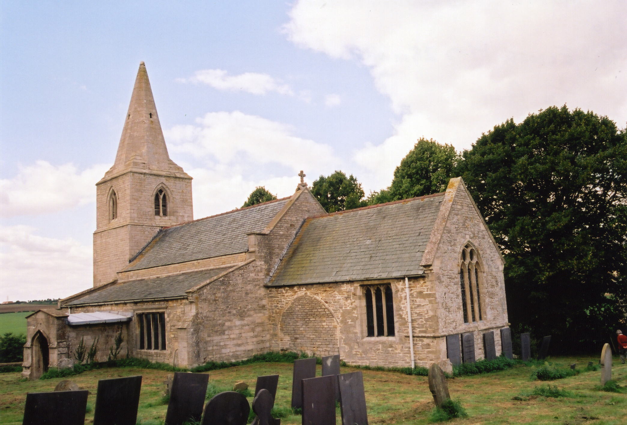
- The Anglican parish church is dedicated to Saint Thomas a Becket, built in the early Norman style.
- Saint Thomas a Becket Church is over 800 years old.
- The church was restored in 1904.
- The church seats 100 (an 1896 Directory tells us 200 are seated).
- Richard CROFT has a photograph of St. Thomas' Church on Geo-graph, taken in December, 2005.
- Here is a photo of the church, taken by Ron COLE (who retains the copyright):
- The Anglican parish register dates from 1542.
- The Lincolnshire FHS has published several marriage indexes and a burial index for the Beltisloe Deanery to make your search easier.
- Check our Church Records page for county-wide resources.
- The parish was in the Colsterworth sub-district of the Grantham Registration District.
- Starting in 1891 the parish was in the "Grantham South" sub-district of the Grantham Registration District.
- Check our Civil Registration page for sources and background on Civil Registration which started in July, 1837.
Bassingthorpe is a village and a parish about 6 miles south-east of Grantham and three miles northwest of Corby. The hamlet of Westby lies in this parish. Lower Bassingthorpe is a hamlet just north of Bassingthorpe village. The parish covers about 1,800 acres.
If you are planning a visit, see:
- The village of Bassingthorpe is just east of the A1 motorway north of Colsterworth.
- See our touring page for visitor services.
The National Gazetteer of Great Britain and Ireland - 1868
"WESTBURY, a hamlet in the parish of Bassingthorpe, wapentake of Beltisloe, parts of Kesteven, county Lincoln, 3½ miles N.W. of Corby. The Roman Catholics have a chapel."
- Ask for a calculation of the distance from Bassingthorpe to another place.
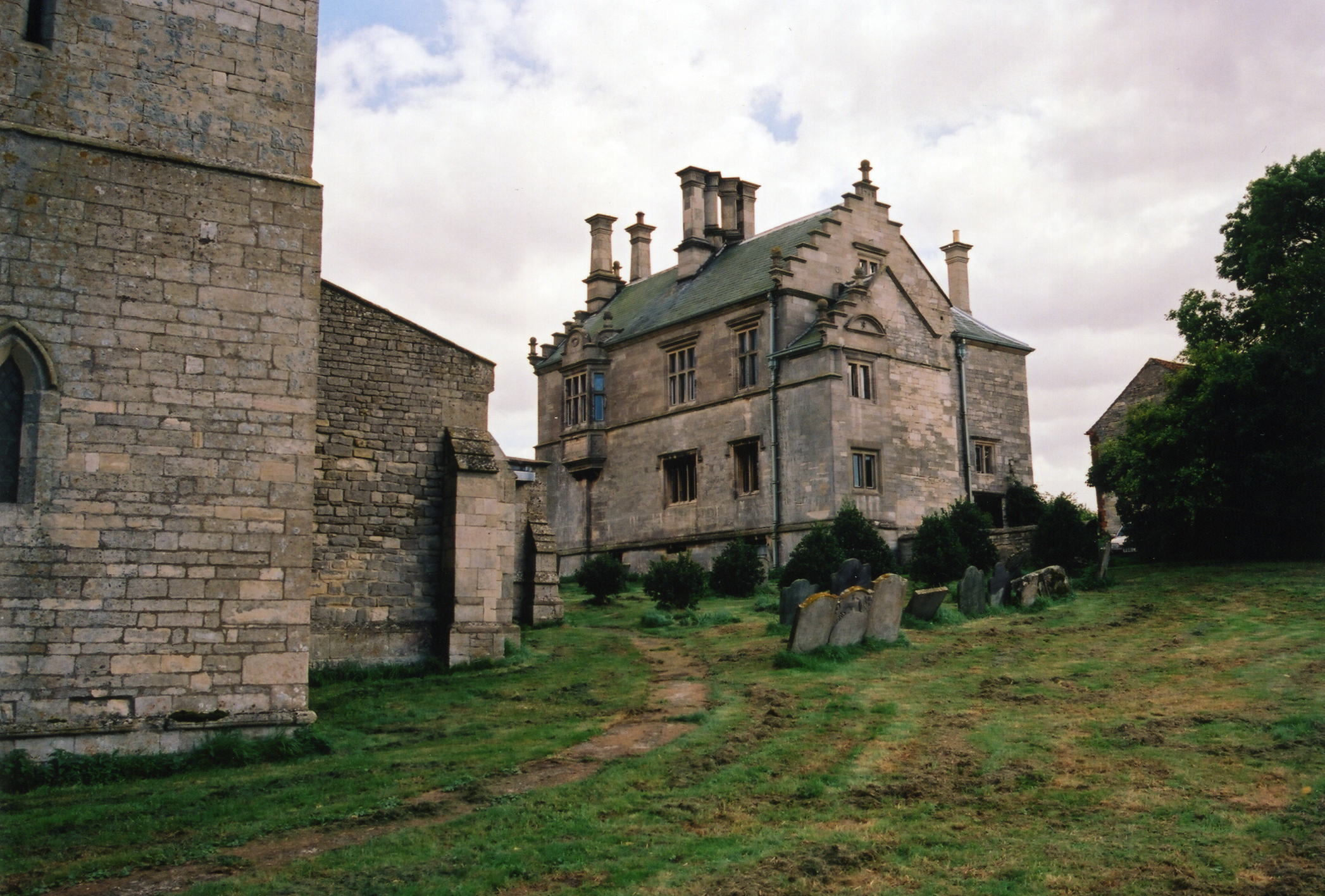
- Bassingthorpe Hall was the seat and property of Thomas CONEY, a rich merchant who was high sheriff of Rutland in 1573.
- In 1896, Bassingthorpe Hall was occupied by Mrs. John GIBSON.
- In the 1950s, Bassingthorpe Hall was owned by a Mr. and Mrs. POLLARD. [Valerie WELLS, 2009]
- Richard CROFT has a photograph of Bassingthorpe Manor on Geo-graph, taken in December, 2005.
- Here is a photo of the Manor House, taken by Ron COLE (who retains the copyright), with the church in the foreground:
- See our Maps page for additional resources.
You can see maps centred on OS grid reference SK966285 (Lat/Lon: 52.845353, -0.567145), Bassingthorpe which are provided by:
- OpenStreetMap
- Google Maps
- StreetMap (Current Ordnance Survey maps)
- Bing (was Multimap)
- Old Maps Online
- National Library of Scotland (Old Ordnance Survey maps)
- Vision of Britain (Click "Historical units & statistics" for administrative areas.)
- English Jurisdictions in 1851 (Unfortunately the LDS have removed the facility to enable us to specify a starting location, you will need to search yourself on their map.)
- Magic (Geographic information) (Click + on map if it doesn't show)
- GeoHack (Links to on-line maps and location specific services.)
- All places within the same township/parish shown on an Openstreetmap map.
- Nearby townships/parishes shown on an Openstreetmap map.
- Nearby places shown on an Openstreetmap map.
For a photograph of the War Memorial plaque in the church and the names on it, see the Roll of Honour site.
- In 1202, the parish is listed as "Basewintorp", meaning "outlying farmstead or hamlet".
- The parish is listed in many sources as "Bassingthorpe-cum-Westby".
- This place was an ancient parish of Lincolnshire and became a Civil Parish when those were established.
- The parish was in the ancient Betisloe Wapentake in the South Kesteven district in the parts of Kesteven.
- This place was abolished as a Civil Parish in 1931.
- The citizens of this parish have elected to forgo a formal Parish Council and now hold periodic Parish Meetings with the residents of Bitchfield to discuss civic and political issues.
- For today's district governance, contact the South Kesteven District Council.
- Bastardy cases would be heard in the Spittlegate petty sessional hearings.
- The poor of the parish have the interest from £50, left by Anne FISHER in 1769.
- As a result of the Poor Law Amendment Act reforms of 1834, the parish became part of the Grantham Poor Law Union.
- The Bitchfield Unified School District was formed in November, 1875, and included this parish. The children attended school in Bitchfield.
- For more on researching school records, see our Schools Research page.