
Hide
--- TEST SYSTEM --- TEST SYSTEM --- TEST SYSTEM ---
Hide
Aylesby
hide
Hide
hide
Hide
hide
Hide
Hide
hide
Hide
Aylesby, par., N. Lincolnshire, 2 miles SW. of Great Coates sta. and 4½ miles W. of Great Grimsby, 2,110 ac., pop. 112.
From: John BARTHOLOMEW's "Gazetteer of the British Isles (1887)"
Hide
The Grimsby Library is an excellent resource with both a Local History section and a Family History section.
- CARROTT, J., IRVING, B., ISSITT, M., JAQUES, D., KENWARD, H., LARGE, F., McKENNA, B. and MILLES, A., "The biological remains," pp. 32-4 in STEEDMAN, K. and FOREMAN, M., Excavations at Aylesby, South Humberside, 1994. Lincolnshire History and Archaeology 30, 12-37, publ. 1995.
- Brian CHESTER has provided a Monument Inscription lookup feature at his website for St. Lawrence Church.
- The parish was in the Grimsby sub-district of the Caistor Registration District.
- In 1890, the parish was allocated to the Grimsby sub-district of the new Grimsby Registration District.
- We have a handful of 1901 census surnames in a text file. Your additions are welcome.
- Check our Census Resource page for county-wide resources.
- The table below gives census piece numbers, where known:
| Census Year | Piece No. |
|---|---|
| 1841 | H.O. 107 / 626 |
| 1861 | R.G. 9 / 2391 |
| 1871 | R.G. 10 / 3416 |
| 1891 | R.G. 12 / 2620 |
| 1901 | R.G. 13 / 3097 |
- There was evidently an early Christian Church here at the time of the Domesday Survey.
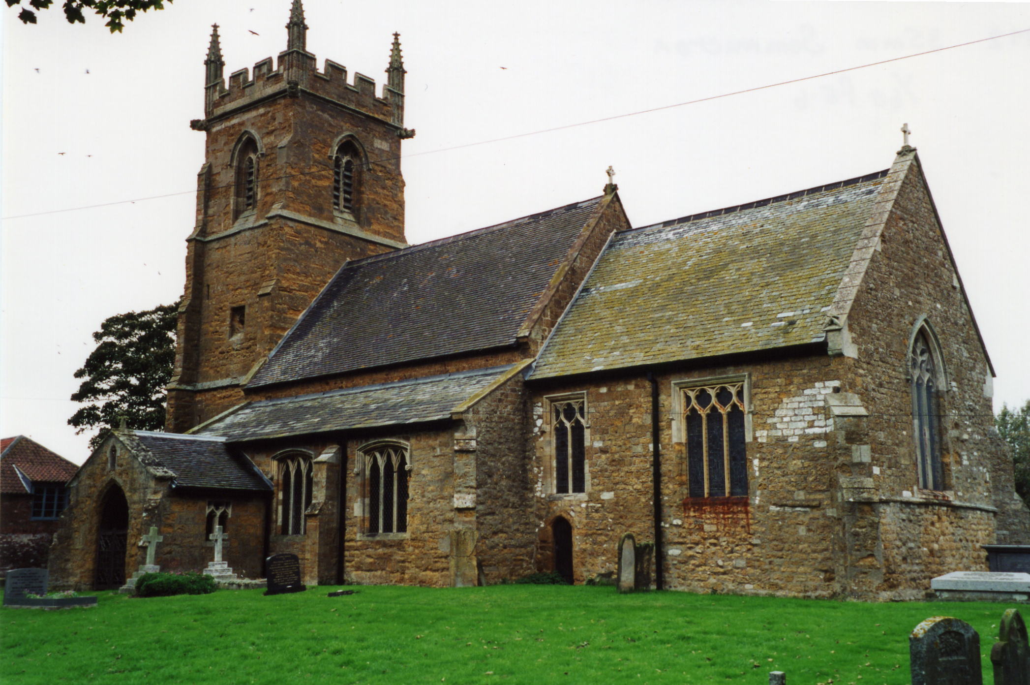
- The Anglican parish church is dedicated to Saint Lawrence. The church is on Church Lane.
- Portions of the church date from the 13th century. The tower was added in the 15th century.
- The church tower was repaired in 1857.
- The church seats 92.
- The church is a Grade I listed building with British Heritage.
- A photograph of St. Lawrence Church is at the Wendy PARKINSON English Church Photographs site, taken by Paul Fenwick.
- Richard CROFT has a photograph of St. Lawrence Church on Geo-graph, taken in August, 2005.
- Here is a photograph St. Lawrence Church supplied by Ron COLE (who retains the copyright):
- The Anglican parish register dates from 1561 thru 1823.
- The Family History Library in Salt Lake City has the parish register extractss from 1561 thru 1721 on microfilm no. 505772 Item 2.
- The church has a list of incumbant vicars from 1222.
- The Lincolnshire FHS has published several marriage indexes and a 1641/2 Protestation Return for the Haverstoe Deanery to make your search easier.
- Kelly's 1913 Directory of Lincolnshire places the parish in the rural deanery of North Grimsby.
- Check our Church Records page for county-wide resources.
- The parish was in the Grimsby sub-district of the Caistor Registration District.
- In 1890, the parish was allocated to the Grimsby sub-district of the new Grimsby Registration District.
- Check our Civil Registration page for sources and background on Civil Registration which began in July, 1837.
Aylesby is a small village and a parish just north of Laceby. The parish covers just over 2,110 acres.
If you are planning a visit:
- By automobile, the village is near the A18 road, 6 miles west of Cleethorpes and north of Laceby.
- Stay in nearby Laceby at the Oaklands Hotel and Country Club
Barton Street
Laceby
Phone: 01472 872248.
- See our touring page for visitor services.
The National Gazetteer of Great Britain and Ireland - 1868
- Ask for a calculation of the distance from Aylesby to another place.
- An archaelogical excavation has found evidence of Iron Age and Romano-British occupation. The parish was apparently a substantial medieval village.
- Metal detector users have found sixteenth and seventeenth century coins, and metalwork of Roman, Middle Saxon and Viking date, in the area of the village.
Chris has a photograph of Aylesby Hall on Geo-graph, taken in October, 2012.
- See our Maps page for additional resources.
You can see maps centred on OS grid reference TA203076 (Lat/Lon: 53.551255, -0.185655), Aylesby which are provided by:
- OpenStreetMap
- Google Maps
- StreetMap (Current Ordnance Survey maps)
- Bing (was Multimap)
- Old Maps Online
- National Library of Scotland (Old Ordnance Survey maps)
- Vision of Britain (Click "Historical units & statistics" for administrative areas.)
- English Jurisdictions in 1851 (Unfortunately the LDS have removed the facility to enable us to specify a starting location, you will need to search yourself on their map.)
- Magic (Geographic information) (Click + on map if it doesn't show)
- GeoHack (Links to on-line maps and location specific services.)
- All places within the same township/parish shown on an Openstreetmap map.
- Nearby townships/parishes shown on an Openstreetmap map.
- Nearby places shown on an Openstreetmap map.
The Knights Templar held land in this parish in the 12th century.
There is no War Memorial in the village but there is a brass plaque in the Parish Church of St. Laurence to the 4 men who fell in the First World War. There is also a framed Roll of Honour for the First World War.
"TO THE GLORY OF GOD AND
IN MEMORY OF THE FOLLOWING
WHO, FROM THE PARISH OF AYLESBY,
GAVE THEIR LIVES FOR
KING AND COUNTRY IN
THE GREAT WAR 1914-1919"
- Pte JOHN ADLARD
East Yorks Regt. March 1915
- Captain FRANCIS WILLMER McAULAY, MA
RFA, TA. May 1916
- Pte WILLIAM MARSHALL
North Staffs Regt. Sept 1917
- Pte HARRY WILKINSON
Duke of Wellington's Regt. Nov 1918
"Faithful unto Death"
"ERECTED BY THE INHABITANTS 1919"
For a photograph of the War Memorial and the names on the plaque, see the Roll of Honour site.
- This place was an ancient parish in county Lincoln and became a modern Civil Parish when those were established.
- The parish was in the ancient Bradley Haverstoe Wapentake in the Central Lindsey district and parts of Lindsey.
- Kelly's 1913 Directory of Lincolnshire places the parish, perhaps erroneously, in the North Lindsey district of the county.
- District governance is provided by the North-East Lincolnshire Council.
- Bastardy cases would be heard in the Grimsby petty session hearings.
- After the 1834 Poor Law Amendment Act, this parish became part of the Caistor Poor Law Union.
- In 1890, this parish was transferred to the new Grimsby Poor Law Union.
- John READMAN has a photograph of the McAuley Memorial Homes (Almshouses) on Geo-graph, taken in June, 2004.
In 1563 there were 45 households in Aylesby (approx. 200 people). There was a marked decline in population during the 17th century.
Year Inhabitants 1801 90 1811 110 1831 144 1841 201 1871 121 1881 112 1891 120 1911 128
- The children of this parish attended Stanford's School in nearby Laceby parish.
- For more on researching school records, see our Schools Research page.