
Hide
--- TEST SYSTEM --- TEST SYSTEM --- TEST SYSTEM ---
Hide
Alvingham
hide
Hide
hide
Hide
hide


Hide
Hide
“ALVINGHAM, a parish in the Marsh division of the hundred of Louth Eske, parts of Lindsey, in the county of Lincoln, 3 miles to the N.E. of Louth. The Louth canal passes through this parish. In the reign of Henry II., a priory of Gilbertine nuns and canons was founded here by Walter de Bee, and was dedicated to the Virgin and St. Athelwold. Its revenue at the Dissolution was £142; it was conferred on the Clintons. The living is a perpetual curacy* in the diocese of Lincoln, value with that of Cockerington, which is annexed to it, £130. It is in the patronage of the Bishop of Lincoln. The church is dedicated to St. Athelwold. There are charities amounting to £8 a year, and some poor's cottages."
”
from The National Gazetteer of Great Britain and Ireland - 1868
Hide
The Library at Louth will prove useful in your research.
- Peter WOOD has a photograph of the Burial Ground that serves two churches on geo-graph, taken in February, 2019.
- The parish was in the Saltfleet sub-district of the Louth Registration District.
- We have a handful of 1901 census surnames in a text file. Your additions are welcome.
- Check our Census Resource page for county-wide resources.
- The table below gives census piece numbers, where known:
| Census Year |
Piece No. |
|---|---|
| 1841 | H.O. 107 / 626 |
| 1851 | H.O. 107 / 2112 |
| 1861 | R.G. 9 / 2385 |
| 1871 | R.G. 10 / 3407 |
| 1881 | R.G. 11 / 3265 |
| 1891 | R.G. 12 / 2610 |
| 1901 | R.G. 13 / 3086 |
- A priory of Gilbertine nuns and canons was dedicated here to the Virgin Mary and Saint Adelwold. It was founded during the reign of Henry II. The chapel was restored as St. Mary Church to serve the adjoining parish of North Cockerington. It was restored in 1841 but has since been declared redundant.
- Richard CROFT provides a photograph of St.Mary's chancel on Geo-graph, taken in April, 2013.
- The Anglican parish church is dedicated to Saint Adelwold, apparently of Norman origin.
- The church seats 110 persons.
- A photograph of St. Adelwold's church is at the Wendy PARKINSON English Church Photographs site.
- Here is a photograph St. Adelwold's Church supplied by Ron COLE (who retains the copyright):
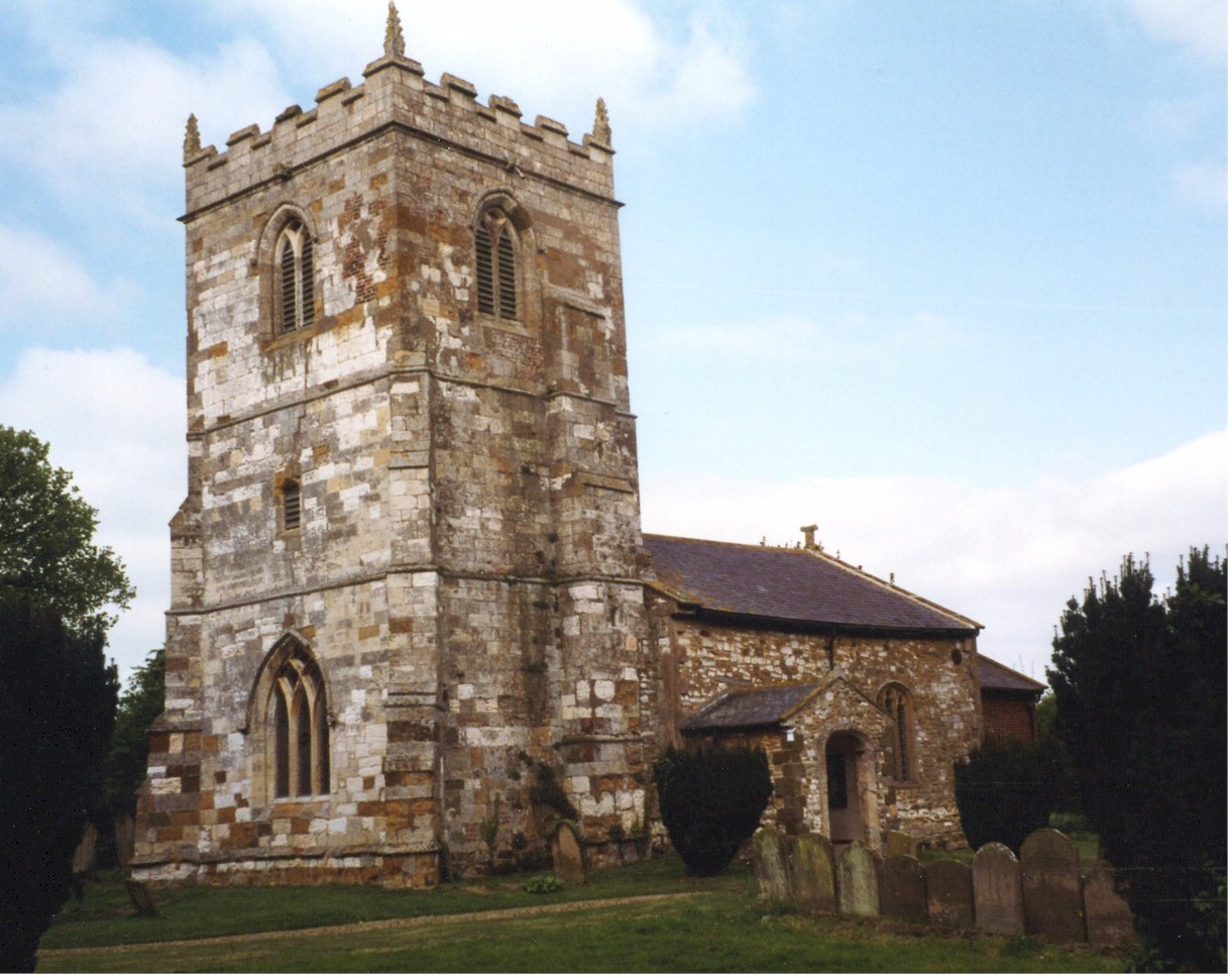
- Here is a side view of St. Adelwold's Church supplied by Ron COLE (who retains the copyright):

- The Anglican parish register dates from 1590.
- The Lincolnshire FHS has published several Marriage indexes and a Burial index for the Louthesk Deanery to make your search easier.
- The Wesleyan Methodists built a chapel here in 1836. The Primitive Methodists had a chapel here, built in 1848. The United Methodists (earlier "Free Methodists") built their chapel in 1854. For information and assistance in researching these chapels, see our non-conformist religions page.
- John READMAN provides a photograph that includes the Wesleyan chapel on Geo-graph, taken in September, 2005.
- Check our Church Records page for county-wide resources.
- The parish was in the Saltfleet sub-district of the Louth Registration District.
- Check our Civil Registration page for sources and background on Civil Registration which began in July, 1837.
Alvingham is a village and a parish just 4 miles northeast of Louth. The parish covers about 1,800 acres and is bordered on the south by Keddington parish and North Cockerington parish.
The village of Alvingham sits just north of the River Lud canal that runs from Louth to Tetney Lock on the North Sea. If you are planning a visit:
- By automobile, take the A16 trunk road south out of Grimsby toward Louth. From Louth head north-east to Alvingham village (about 3 miles).
- J. THOMAS has a photograph of the Village Sign on Geo-graph, taken in March, 2015.
- Better behave during your visit! Simon HUGUET provides a photograph of the village stocks on Geo-graph, taken in September, 2008.
- Visit our touring page for visitor services.
The National Gazetteer of Great Britain and Ireland - 1868
- Ask for a calculation of the distance from Alvingham to another place.
- The medieval village of Alvingham is just north of High Street.
- Chris ? has a photograph of the medieval village area on Geo-graph, taken in December, 2015.
- The Lincolnshire Film Archives have a short film on Alvingham, made in 1982. Ask for film no. 461.
- See our Maps page for additional resources.
You can see maps centred on OS grid reference TF363912 (Lat/Lon: 53.400034, 0.048581), Alvingham which are provided by:
- OpenStreetMap
- Google Maps
- StreetMap (Current Ordnance Survey maps)
- Bing (was Multimap)
- Old Maps Online
- National Library of Scotland (Old Ordnance Survey maps)
- Vision of Britain (Click "Historical units & statistics" for administrative areas.)
- English Jurisdictions in 1851 (Unfortunately the LDS have removed the facility to enable us to specify a starting location, you will need to search yourself on their map.)
- Magic (Geographic information) (Click + on map if it doesn't show)
- GeoHack (Links to on-line maps and location specific services.)
- All places within the same township/parish shown on an Openstreetmap map.
- Nearby townships/parishes shown on an Openstreetmap map.
- Nearby places shown on an Openstreetmap map.
- On the outside wall of the Wesleyan Methodist chapel is a marble tablet in memory of those who served in World War I.
- The Village Hall is a building left over from Royal Army structures thrown up during World War II. The Village Hall bilding was left standing and the property owners donated it to the parish.
- John READMAN provides this list for Alvingham parish.
ALVINGHAM & COCKERINGTON - ROLL OF HONOUR (from the parish church)
| Surname | Given names | Unit or vessel | Died | Notes |
|---|---|---|---|---|
| Bratton | Charles | 20th Notts | 01 Dec 1915 | |
| Wright | Sidney | 8th Lincs | 02 July 1916 | |
| Hand | Samuel | 14th Durham | 18 Sept 1916 | |
| Hand | Charles | 5th Lincs | a | |
| Hand | Fred | R. Engs. | a | |
| Hand | Robert | 3rd Lincs | a | |
| Phillipson | Charles | R. Engs. | a | |
| Phillipson | George | 5th Lincs | ||
| Bett | Thomas | Lincs. Yeomanry | a | |
| Bett | Roy | R.F.A. | a | |
| Grundy | Fred | R.F.A. | a | |
| Grundy | Charles | 3rd Lincs | a | |
| Trafford | Percy | 3rd Lincs | a c | |
| Trafford | Fred | A.M.C. | a | |
| Trafford | Owen | R. Engs | a | |
| Trafford | Morris | A.M.C. | a | |
| Bowers | Charles | A.M.C. | ||
| Thompson | John | A.M.C. | b | |
| Thompson | Neville | L. Fusiliers | a | |
| Portas | Charles | 6th Lincs | a | |
| Johnson | Sydney | 6th Lincs | a | |
| Ashley | William | 2/5 Lincs | a | |
| Blades | William | 2/5 Lincs | a | |
| Blades | George | Northumberland Fusiliers | a | |
| Shucksmith | Thomas | Royal Mark | a | |
| Lill | Samuel | 13th East Yorks | a |
Notes:
- = Not in CWGC database
- = Need more info
- Percy TRAFFORD, 1911 census in Alvingham, 18, born Alvingham.
John advises: "There is a separate list in the Wesleyan chapel in Alvingham."
- This place was an ancient parish in Lincoln county and became a modern Civil Parish when those were established.
- J. THOMAS has a photograph of the Village Hall and Social Club on Geo-graph, taken in March, 2015.
- The parish was in the Marsh division of the ancient Louth Eske Wapentake in the East Lindsey district in the parts of Lindsey.
- For today's district governance, see the East Lindsey District Council.
- The poor had 20 Shillings per year, from a fund left by a Mr. MADDISON (undated).
- The Common Lands and open fields were enclosed here in 1819. As a result of that enclosure, the parish had two cottages, divided into 4 tenements, for the occupation of poor families.
- Bastardy cases would be heard in the Louth petty session hearings.
- After the Poor Law Amendment Act reforms of 1834, this parish became part of the Louth Poor Law Union.
- The children of this parish attend school in North Cockerington.
- For more on researching school records, see our Schools Research page.