
Hide
--- TEST SYSTEM --- TEST SYSTEM --- TEST SYSTEM ---
Hide
Burial ground Society of Friends, Sunbrick
hide
Hide
Hide

Hide
Burial ground,
Sunbrick
Lancashire
Hide
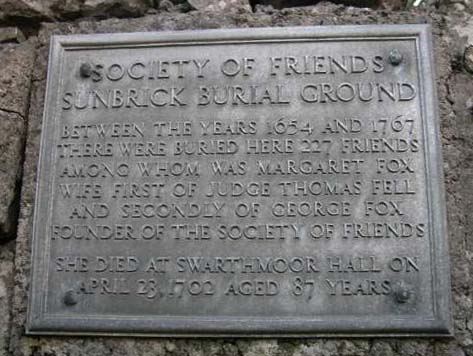
Like many burial grounds used by the Religious Society of Friends, Sunbrick is a small and bleak walled enclosure, reached through a simple archway. In accordance with early Quaker custom, there are no headstones, and very few obvious clues as to the significance of this particular site on Birkrigg Common, other than a metal plaque in the gateway and one worn inscription.
There are no surviving registers or other records which relate exclusively to Sunbrick. However, a list of 227 people interred there between 1654-1767 was published in the Cumberland & Westmorland Antiquarian and Archaeological Society's volume of transactions for 1906. Most of these persons would have been associated with the Quaker meeting house two or three miles away at Swarthmoor.
- OpenStreetMap
- Google Maps
- StreetMap (Current Ordnance Survey maps)
- Bing (was Multimap)
- Old Maps Online
- National Library of Scotland (Old Ordnance Survey maps)
- Vision of Britain (Click "Historical units & statistics" for administrative areas.)
- English Jurisdictions in 1851 (Unfortunately the LDS have removed the facility to enable us to specify a starting location, you will need to search yourself on their map.)
- Magic (Geographic information) (Click + on map if it doesn't show)
- GeoHack (Links to on-line maps and location specific services.)
Hide
hide


