
Hide
--- TEST SYSTEM --- TEST SYSTEM --- TEST SYSTEM ---
Hide
Quernmore
hide
Hide
Hide
hide
Hide
hide
Hide
Hide
QUERNMOOR, a township-chapelry in Lancaster parish, Lancashire; 3 miles E S E of Lancaster r. station. Post-town, Lancaster. Acres, 6,593. Real property, £5,611. Pop., 563. Houses, 104. Q. Park and most of the land belong to W. J. Garnett, Esq. Escowbeck Hall is the seat of J. Greg, Esq. The living is a rectory in the diocese of Manchester. Value, £170.* Patron, the Vicar of Lancaster. The church was rebuilt in 1861, at a cost of £3,000; and is in the decorated English style, with a tower. There are a Quakers' chapel and a national school.
John Marius Wilson, Imperial Gazetteer of England and Wales (1870-72)
Hide
| Rigg Lane, Quernmore, Society of Friends |
Details about the census records, and indexes for Quernmore.
| Rigg Lane, Quernmore, Society of Friends |
The Register Office covering the Quernmore area is Lancaster.
The National Gazetteer of Great Britain and Ireland - 1868
"QUERNMORE, a township and chapelry in the parish of Lancaster, hundred of Lonsdale South of the Sands, county Lancaster, 3 miles S.E. of Lancaster, its post town. It was formerly a forest, and a great portion is still occupied by fells and moorland. The inhabitants are chiefly engaged in agriculture. The living is a perpetual curacy in the diocese of Manchester, value £137, in the patronage of the Vicar of Lancaster. The church, dedicated to St. Peter, has a tower containing one bell. There is an endowed National school for both sexes, also a free school. The principal residence is Quernmoor Park. The manor is held by the crown."
- Ask for a calculation of the distance from Quernmore to another place.
In 1835 Quernmore was a township in the parish of Lancaster.
View maps of Quernmore and places within its boundaries.
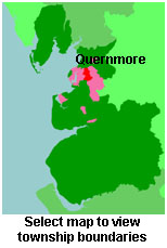
View a map of the boundaries of this town/parish.
You can see maps centred on OS grid reference SD525608 (Lat/Lon: 54.04072, -2.726787), Quernmore which are provided by:
- OpenStreetMap
- Google Maps
- StreetMap (Current Ordnance Survey maps)
- Bing (was Multimap)
- Old Maps Online
- National Library of Scotland (Old Ordnance Survey maps)
- Vision of Britain (Click "Historical units & statistics" for administrative areas.)
- English Jurisdictions in 1851 (Unfortunately the LDS have removed the facility to enable us to specify a starting location, you will need to search yourself on their map.)
- Magic (Geographic information) (Click + on map if it doesn't show)
- GeoHack (Links to on-line maps and location specific services.)
- All places within the same township/parish shown on an Openstreetmap map.
- Nearby townships/parishes shown on an Openstreetmap map.
- Nearby places shown on an Openstreetmap map.
For probate purposes prior to 1858, Quernmore was in the Archdeaconry of Richmond, in the Diocese of Chester. The original Lancashire wills for the Archdeaconry of Richmond are held at the Lancashire Record Office.
You can also see Family History Societies covering the nearby area, plotted on a map. This facility is being developed, and is awaiting societies to enter information about the places they cover.