
Hide
--- TEST SYSTEM --- TEST SYSTEM --- TEST SYSTEM ---
Hide
Over Wyresdale
hide
Hide
Hide
hide
Hide
hide
Hide
Hide
WYERSDALE (Over), a township-chapelry in Lancaster parish, Lancashire; on the river Wyre, 4¾ miles E by N of Bay-Horse r. station, and 7 SE of Lancaster. Post town, Lancaster. Acres, 16,938. Real property, £4,728. Pop. in 1851, 680; in 1861, 524. Houses, 90. The decrease of pop. arose from the destruction, by fire, of a cotton factory. The manor belongs to H. Garnett, Esq. The living is a vicarage in the diocese of Manchester. Value, £170.* Patron, the Vicar of Lancaster. The church is plain. There are Quaker and Wesleyan chapels, and an endowed school.
John Marius Wilson, Imperial Gazetteer of England and Wales (1870-72)
Hide
Local studies information is held at Lancaster library.
| Plantation Lane Society of Friends, Abbeystead |
Details about the census records, and indexes for Over Wyresdale.
| Plantation Lane Society of Friends, Abbeystead |
The Register Office covering the Over Wyresdale area is Lancaster.
The National Gazetteer of Great Britain and Ireland - 1868
"OVER WYRESDALE, a chapelry in the parish of Lancaster, hundred of Lonsdale South of the Sands, county Lancaster, 6 miles N.E. of Garstang, and 9 S.E. of Lancaster. The district was once forest, but is now chiefly open moor and fell abounding with game. It is situated on the York border near the river Wyer, and belongs to the Duchy of Lancaster. The living is a curacy in the diocese of Manchester, value £150, in the patronage of the vicar. There is a school founded and endowed by William Cawthorne in 1683, and a school supported by the Society of Friends.
- Ask for a calculation of the distance from Over Wyresdale to another place.
In 1835 Over Wyresdale was a township in the parish of Lancaster.
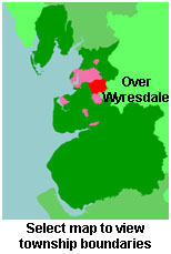
View maps of Over Wyresdale and places within its boundaries.
View a map of the boundaries of this town/parish.
You can see maps centred on OS grid reference SD577546 (Lat/Lon: 53.98528, -2.646782), Over Wyresdale which are provided by:
- OpenStreetMap
- Google Maps
- StreetMap (Current Ordnance Survey maps)
- Bing (was Multimap)
- Old Maps Online
- National Library of Scotland (Old Ordnance Survey maps)
- Vision of Britain (Click "Historical units & statistics" for administrative areas.)
- English Jurisdictions in 1851 (Unfortunately the LDS have removed the facility to enable us to specify a starting location, you will need to search yourself on their map.)
- Magic (Geographic information) (Click + on map if it doesn't show)
- GeoHack (Links to on-line maps and location specific services.)
- All places within the same township/parish shown on an Openstreetmap map.
- Nearby townships/parishes shown on an Openstreetmap map.
- Nearby places shown on an Openstreetmap map.
For probate purposes prior to 1858, Over Wyresdale was in the Archdeaconry of Richmond, in the Diocese of Chester. The original Lancashire wills for the Archdeaconry of Richmond are held at the Lancashire Record Office.
You can also see Family History Societies covering the nearby area, plotted on a map. This facility is being developed, and is awaiting societies to enter information about the places they cover.