
Hide
--- TEST SYSTEM --- TEST SYSTEM --- TEST SYSTEM ---
Hide
Lathom
hide
Hide
Hide
hide
Hide
hide


Hide
Hide
Lathom, township and local government district, Ormskirk par., N. Lancashire, on river Donglas and Leeds and Liverpool Canal, 4 miles NE. of Ormskirk, 8694 ac., pop. 4161. Lathom House, seat of Lord Skelmersdale, occupies the site of the ancient house of Lathom, defended by the Countess of Derby against the Parliamentary forces.
John Bartholomew, Gazetteer of the British Isles (1887)
Hide
Local studies information is held at Ormskirk and Skelmersdale libraries.
Details about the census records, and indexes for Lathom.
The Register Office covering the Lathom area is West Lancashire.
"NEWBURGH, (or Newbrough), a hamlet in the parish of Ormskirk, county Lancaster, 5 miles N.E. of Ormskirk. It is situated on the river Douglas.
- Ask for a calculation of the distance from Lathom to another place.
In 1835 Lathom was a township in the parish of Ormskirk.
Information about boundaries and administrative areas is available from A Vision of Britain through time.
View maps of Lathom and places within its boundaries.
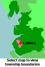
View a map of the boundaries of this town/parish.
You can see maps centred on OS grid reference SD459102 (Lat/Lon: 53.585772, -2.818476), Lathom which are provided by:
- OpenStreetMap
- Google Maps
- StreetMap (Current Ordnance Survey maps)
- Bing (was Multimap)
- Old Maps Online
- National Library of Scotland (Old Ordnance Survey maps)
- Vision of Britain (Click "Historical units & statistics" for administrative areas.)
- English Jurisdictions in 1851 (Unfortunately the LDS have removed the facility to enable us to specify a starting location, you will need to search yourself on their map.)
- Magic (Geographic information) (Click + on map if it doesn't show)
- GeoHack (Links to on-line maps and location specific services.)
- All places within the same township/parish shown on an Openstreetmap map.
- Nearby townships/parishes shown on an Openstreetmap map.
- Nearby places shown on an Openstreetmap map.
For probate purposes prior to 1858, Lathom was in the Archdeaconry of Chester, in the Diocese of Chester. The original Lancashire wills for the Archdeaconry of Chester are held at the Lancashire Record Office.
You can also see Family History Societies covering the nearby area, plotted on a map. This facility is being developed, and is awaiting societies to enter information about the places they cover.