
Hide
--- TEST SYSTEM --- TEST SYSTEM --- TEST SYSTEM ---
Hide
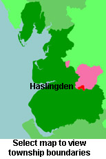
Haslingden
hide
Hide
Hide
hide
Hide
hide


Hide
Hide
"HASLINGDEN, a town, a township-chapelry, a subdistrict, and a district in Lancashire. The town stands adjacent to the East Lancashire railway, near Rossendale forest, 4 miles S by E of Accrington, and 16 N by W of Manchester. The chief employments are in cotton factories, sheeting and fulling mills, iron foundries, size works, a brewery, and stone quarries. Several mansions and handsome villas are in the neighbourhood. Pop. of the town, in 1851, 6,154; in 1861, 6,929. Houses, 1,295. The chapelry is in Whalley parish, and comprises 4,420 acres. Real property, £25,479; of which £575 are in gas works, and £1,007 in quarries. Pop. in 1851, 9,030; in 1861, 10,109. Houses, 1,935. The manor belongs to the Duke of Buccleuch. The landed property is chiefly divided among five. The living is a vicarage in the diocese of Manchester. Value, £300. * Patrons, Hulme's Trustees. The sub-district contains also the township of Henheads. Acres, 4,780. Pop., 10,320. Houses, 1,975."
John Marius Wilson, Imperial Gazetteer of England and Wales (1870-72) more ...
Hide
Haslingden Library,
Higher Deardengate,
Haslingden
Rossendale
BB4 5LQ
Details about the census records, and indexes for Haslingden.
| St James, Haslingden, Church of England |
| St Paul Free Church of England, Haslingden |
| St Peter, Laneside, Church of England |
| St Stephen, Haslingden Grane, Church of England |
| Chapel St Particular Baptist, Haslingden |
| Ebenezer Baptist, Haslingden |
| Trinity, Haslingden, Baptist |
| Dearden Gate Independent, Haslingden |
| Grane Rd Cemetery, Haslingden |
The Register Office covering the Haslingden area is Hyndburn and Rossendale.
"ROSE-BANK, a hamlet in the parish of Whalley, county Lancaster, 2 miles S. of Haslingden, and 14 N.W. of Manchester. It is situated in the valley of the river Irwell, near Edenfield, and on the borders of Rosendale Forest. There are extensive print works."
"HELMSHORE, a hamlet in the parish of Whalley, county Lancaster, 12 miles N.W. of Manchester. It is a station on the Manchester branch of the West Lancashire and Yorkshire railway, and is situated near Rossendale Forest and the river Irwell."
- Ask for a calculation of the distance from Haslingden to another place.
Haslingden Roots are a voluntary group of individuals who set up to help people research their family history of the area.
In 1835 Haslingden was a chapelry and township in the parish of Whalley.
Information about boundaries and administrative areas is available from A Vision of Britain through time.
View a map of the boundaries of this town/parish.
You can see maps centred on OS grid reference SD765229 (Lat/Lon: 53.701765, -2.35749), Haslingden which are provided by:
- OpenStreetMap
- Google Maps
- StreetMap (Current Ordnance Survey maps)
- Bing (was Multimap)
- Old Maps Online
- National Library of Scotland (Old Ordnance Survey maps)
- Vision of Britain (Click "Historical units & statistics" for administrative areas.)
- English Jurisdictions in 1851 (Unfortunately the LDS have removed the facility to enable us to specify a starting location, you will need to search yourself on their map.)
- Magic (Geographic information) (Click + on map if it doesn't show)
- GeoHack (Links to on-line maps and location specific services.)
- All places within the same township/parish shown on an Openstreetmap map.
- Nearby townships/parishes shown on an Openstreetmap map.
- Nearby places shown on an Openstreetmap map.
The Workhouse site has an interesting description of Haslingden workhouse.
For probate purposes prior to 1858, Haslingden was in the Archdeaconry of Chester, in the Diocese of Chester. The original Lancashire wills for the Archdeaconry of Chester are held at the Lancashire Record Office.
You can also see Family History Societies covering the nearby area, plotted on a map. This facility is being developed, and is awaiting societies to enter information about the places they cover.