
Hide
--- TEST SYSTEM --- TEST SYSTEM --- TEST SYSTEM ---
Hide
Cheetham
hide
Hide
Hide
hide
Hide
hide


Hide
Hide
Cheetham, township, forming N. district of Manchester, SE. Lancashire, 919 ac., pop. 25,721; contains Cheetham Hill; P.O., T.O., 1 Bank.
John Bartholomew, Gazetteer of the British Isles (1887)
Hide
Local studies information is held at Manchester central library.
| Cheetham, Cheetham Hill, Congregational |
| St Chad, Cheetham, Roman Catholic |
Details about the census records, and indexes for Cheetham.
The Register Office covering the Cheetham area is Manchester.
Old pictures of Cheetham.
The National Gazetteer of Great Britain and Ireland - 1868
"CHEETHAM, a chapelry in the parish and borough of Manchester, in the county of Lancaster. It is situated to the N. of Manchester, but may be said to commence in Manchester itself. The living is a rectory in the diocese of Manchester, in the patronage of the Dean and Chapter. The church is dedicated to St. Mark, and was, before the Reetorial Bill passed, simply a chapel of ease. There is another church, dedicated to St. Luke; the living is also a rectory, value £258, in the patronage of the trustees. Here the Wesleyans and Independents have places of worship. In Edward III.'s time this was the estate of Sir George Cheetham, and is described as a "little village to the N. of Manchester, which gave its name to the family of Cheetham." Smedley Old Hall, which is situated in this chapelry, formerly belonged to the Cheethams. Of this family was Humphrey Cheetham, who is included by Fuller among his "Worthies of England." He was high sheriff of the county of Lancaster A.D. 1635, "discharging that office," says Fuller, "with so great honour, that very good gentlemen of birth and estate wear his cloth at the assize, to testify their unfeigned affection to him." Having amassed a large property by the cotton trade, he left a handsome endowment for the education of 40 boys, to be selected from the neighbouring towns, and also funds for the foundation of the fine library and college which now adorn Manchester. He further bequeathed £200 to purchase "godly English books," to be chained upon desks in the churches of Manchester and Bolton, and the chapels of Turton, Walmsley, and Gorton. His will is dated 16th December, 1651, and his trustees were made a body corporate by charter of Charles II."
"SMEDLEY, a hamlet in the parish and borough of Manchester, county Lancashire, 1 mile N. of Manchester."
"RED BANK, an ecclesiastical district in the parish and borough of Manchester, county Lancaster. The living is a rectory in the diocese of Manchester, value £190, in the patronage of the bishop. The church is a modern structure dedicated to St. Thomas."
- Ask for a calculation of the distance from Cheetham to another place.
In 1835 Cheetham was a township in the parish of Manchester.
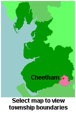
View maps of Cheetham and places within its boundaries.
View a map of the boundaries of this town/parish.
You can see maps centred on OS grid reference SD843004 (Lat/Lon: 53.500008, -2.238448), Cheetham which are provided by:
- OpenStreetMap
- Google Maps
- StreetMap (Current Ordnance Survey maps)
- Bing (was Multimap)
- Old Maps Online
- National Library of Scotland (Old Ordnance Survey maps)
- Vision of Britain (Click "Historical units & statistics" for administrative areas.)
- English Jurisdictions in 1851 (Unfortunately the LDS have removed the facility to enable us to specify a starting location, you will need to search yourself on their map.)
- Magic (Geographic information) (Click + on map if it doesn't show)
- GeoHack (Links to on-line maps and location specific services.)
- All places within the same township/parish shown on an Openstreetmap map.
- Nearby townships/parishes shown on an Openstreetmap map.
- Nearby places shown on an Openstreetmap map.
For probate purposes prior to 1858, Cheetham was in the Archdeaconry of Chester, in the Diocese of Chester. The original Lancashire wills for the Archdeaconry of Chester are held at the Lancashire Record Office.
You can also see Family History Societies covering the nearby area, plotted on a map. This facility is being developed, and is awaiting societies to enter information about the places they cover.