
Hide
--- TEST SYSTEM --- TEST SYSTEM --- TEST SYSTEM ---
Hide
Boothstown
hide
Hide
Hide
hide
Hide
hide


Hide
Hide
BOOTHSTOWN, a hamlet in Worsley township, Lancashire; 7 miles WSW of Manchester. It has a post office under Manchester.
John Marius Wilson, Imperial Gazetteer of England and Wales (1870-72)
Hide
Details about the census records, and indexes for Boothstown.
| Holy Family, Boothstown, Roman Catholic |
The Register Office covering the Boothstown area is Salford.
The National Gazetteer of Great Britain and Ireland - 1868
"BOOTHSTOWN, a hamlet in the township of Worsley, and parish of Eccles, hundred of Salford, in the county palatine of Lancaster, 6 miles to the W. of Manchester."
- Ask for a calculation of the distance from Boothstown to another place.
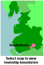
View a map of the boundaries of this town/parish.
You can see maps centred on OS grid reference SJ721999 (Lat/Lon: 53.495087, -2.421289), Boothstown which are provided by:
- OpenStreetMap
- Google Maps
- StreetMap (Current Ordnance Survey maps)
- Bing (was Multimap)
- Old Maps Online
- National Library of Scotland (Old Ordnance Survey maps)
- Vision of Britain (Click "Historical units & statistics" for administrative areas.)
- English Jurisdictions in 1851 (Unfortunately the LDS have removed the facility to enable us to specify a starting location, you will need to search yourself on their map.)
- Magic (Geographic information) (Click + on map if it doesn't show)
- GeoHack (Links to on-line maps and location specific services.)
- All places within the same township/parish shown on an Openstreetmap map.
- Nearby townships/parishes shown on an Openstreetmap map.
- Nearby places shown on an Openstreetmap map.
You can also see Family History Societies covering the nearby area, plotted on a map. This facility is being developed, and is awaiting societies to enter information about the places they cover.