
Hide
--- TEST SYSTEM --- TEST SYSTEM --- TEST SYSTEM ---
Hide
Thurlestone
hide
Hide
hide
- Almanacs◬
- Archives & Libraries◬
- Bibliography◬
- Biography
- Business & Commerce Records◬
- Cemeteries
- Census
- Chronology◬
- Church History
- Church Records
- Churches
- Civil Registration◬
- Correctional Institutions◬
- Court Records◬
- Description & Travel
- Directories
- Emigration & Immigration◬
- Encyclopaedias & Dictionaries◬
- Folklore◬
- Gazetteers
- Genealogy
- Handwriting◬
- Heraldry◬
- Historical Geography◬
Hide
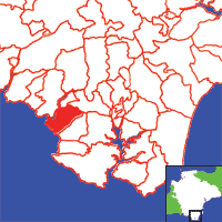
Click on map to view parish boundaries in detail.
Hide
Hide
hide
- History
- Jewish History◬
- Land & Property◬
- Language & Languages◬
- Manors◬
- Maps
- Medical Records◬
- Merchant Marine◬
- Military History
- Names, Geographical◬
- Names, Personal
- Newspapers◬
- Occupations◬
- Periodicals◬
- Politics & Government◬
- Poor Houses, Poor Law◬
- Population◬
- Probate Records
- Schools◬
- Social Life & Customs◬
- Societies◬
- Taxation◬
- Voting Registers◬
Hide
"THURLESTONE, 4½ miles W.S.W. of Kingsbridge, is a small scattered village, on rising ground, near the beach of Bigbury Bay. Its parish contains 437 souls, and 1763 acres of fertile land, including the hamlets of Buckland, Avenmouth, and Bantham, the latter of which is a small fishing village, with fine hard sands, and a salmon pool and harbour for barges. The Earl of Devon is lord of the manor, but part of the parish belongs to several smaller freeholders. The river Aven bounds the parish on the north, and the Bay on the west. On the coast is a remarkable arched rock, through which boats have sailed. It has for centuries braved the foaming surge; hence the proverb, "Brave every shock, Like Thurlestone Rock." It is of red conglomerate formation. Clannacombe, a large Elizabethan mansion, which has been modernised, is the seat of H.R. Square, Esq. The Church is an ancient structure, with a tower and five bells. The pulpit is finely carved, and partly composed of elegant panels taken from the screen. The rectory. valued in K.B. at £25. 10s., and in 1831 at £383, is in the patronage of Sir J.B.Y. Buller, Bart., and incumbency of the Rev. P.A. Ilbert, M.A., who has 36A. of glebe, and a large and handsome residence, erected by himself. The parish school, established in 1844, is supported by the rector." [From White's Devonshire Directory (1850)]
A parish in Stanborough Hundred, the Archdeaconry of Totnes and the Diocese of Exeter. Regarded as part of the South Hams area.
Hide
McDonald, Kendall. More than Just-a-Cottage: a village in the South Hams. Sevenoaks: Ashgrove Press (1981) 176p, 4 plates: ill, map. [ISBN 0906798132]
Snowdon, Hubert N. Born to farm in Devon: by horse and handtool at Thurlestone 1918-1939. [Thurlestone?]: The Author (1996) 60p: ill, ports. [Westcountry Studies Library - s301.35/THU/SNO]
Square, J. Harris. Epitaphs from Churches, Churchyards and Burial Places in the Following Parishes: Kingsbridge, South Milton, East Allington, Dodbrooke, Malborough, Blackawton, West Alvington, Sherford, Charleton, Thurlestone, Churchstow, East Portlemouth. Devonshire Association Trans. 29 (1897) pp.182-215. [Index]
Thurlestone - from J. Stabb. Some Old Devon Churches (London: 1908-16).
Coope, Frank Egerton. Thurlestone Church and Parish. Mayflower Press (1918). [DFHS Library 942.35/THU*]
Parish Registers going back to 1558 are held in the Devon Record Office.
The Devon FHS publishes indexes covering (as of June 2004): Baptisms 1813-1839, Marriages 1754-1837, Burials 1813-1838 - for details see their Devon Parish List.
Other churches and chapels (with pre-1840 records):
- Wesleyan Chapel: Registers for c1813-37 - see Kingsbridge (PRO RG 4/1088)
Nothing entered into the IGI (as of Jan 1993).
Indexes to baptisms (1610-1753), baptisms (1754-1877), banns (1837-1844), marriages (1610-1753), marriages & banns (1854-1812), marriages (1813-1837), burials (1610-1805), and burials (1813-1906), from the Parishes of the South Hams website.
Deanery of Woodleigh Baptisms 1813-1839, Marriages 1754-1837 and Burials 1813-1988 - CD-ROM, Exeter, Devon FHS (2006). [Index of Aveton Gifford: Baptisms (1813-1839), Marriages (1754-1837), Burials (1813-1837), Bigbury: Baptisms (1813-1839), Marriages (1754-1837, Burials 1813-1837), Buckland-Tout-Saints: Baptisms (1813-1839), Marriages (1818-1822), Burials (1813-1988), Charleton: Baptisms (1813-1839), Marriages (1754-1837), Burials (1780-1812), Chivelstone: Baptisms (1813-1839), Marriages (1754-1837), Burials (1800-1837), Churchstow: Baptisms (1813-1839), Marriages (1754-1837), Burials (1813-1848), Dodbrooke: Baptisms (1813-1839), Marriages (1754-1837), Burials (1813-1837), East Allington: Baptisms (1813-1839), Marriages (1754-1837), Burials (1813-1837), East Portlemouth: Baptisms (1813-1839), Marriages (1754-1837), Burials (1813-1837), Kingsbridge: Baptisms (1813-1839), Marriages (1754-1837), Burials (1813-1837), Kingsbridge Ind.: Burials (1793-1897), Loddiswell: Baptisms (1813-1839), Marriages (1754-1837), Burials (1813-1837), Malborough: Baptisms (1813-1839), Marriages (1754-1837), Burials (1813-1837), Moreleigh: Baptisms (1813-1839), Marriages (1754-1837), Burials (1813-1837), Ringmore: Baptisms (1813-1839), Marriages (1754-1837), Burials (1764-1814), Salcombe: Baptisms (1813-1839), Sherford: Baptisms (1813-1839), Marriages (1754-1837), Burials (1800-1837), Slapton: Baptisms (1813-1839), Marriages (1754-1837), Burials (1813-1837), South Huish: Baptisms (1813-1839), Marriages (1754-1837), Burials (1813-1856), South Milton: Baptisms (1813-1839), Marriages (1754-1837), Burials (1813-1838), South Pool: Baptisms (1813-1839), Marriages (1754-1837), Burials (1813-1838), Stokenham: Baptisms (1813-1839), Marriages (1754-1837), Burials (1813-1837), Stokenham Ind.: Burials (1795-1836), Thurlstone: Baptisms (1813-1839), Marriages (1754-1837), Burials (1813-1838), West Alvington: Baptisms (1813-1839), Marriages (1754-1837), Burials (1813-1837), Woodleigh: Baptisms (1813-1839), Marriages (1754-1837), Burials (1813-1837)]
Section on Thurlestone from Samuel Lewis: A Topographical Dictionary of England (1831), provided by Mel Lockie.
Barber, Chips. Around & About Hope Cove and Thurlestone. Pinhoe, Exeter: Obelisk Publications. [ISBN 1899073663].
Transcription of the entry in White's Devonshire Directory (1850) by Terry Partridge.
Transcript of entry in Morris and Co's Commercial Directory and Gazetteer of Devon (1870), provided by Val Henderson.
The transcription of the section for this parish from the National Gazetteer (1868), provided by Colin Hinson.
- Ask for a calculation of the distance from Thurlestone to another place.
The South Hams Genealogical Information Resource website offers lookups in their records concerning this parish.
The Cornishes of South Devon (archived copy), by Duncan Reid.
Du Boulay, James T. Houssemayne. Notes to accompany a pedigree of the family of Cornyshe of Thurlestone in the county of Devon. Winchester: Warren and Son, 1903 [Raymond: Includes folded pedigree, 16-19th c.]
Editors. The Cornish family. Devon & Cornwall Notes & Queries 3:1, (1904) pp.23-24. [Full text]
Oswald, Neville. Thurlestone Families, Trans. Dev. Assoc., vol. 110, (1978) pp.53-68.
Coope, Frank Egerton. Thurlestone church and parish (2nd ed.) Kingsbridge: The Author [1920] 130p, plates: ill, plan. [Westcountry Studies Library - B/THU/0001/COO] [Internet Archive copy]
Fox, Clare. Bantham 2000 B.C.-1953 A.D.: exhibition of village history, [Bantham], [Exhibition Cttee] (1953) 12p, plates: ill [Westcountry Studies Library sB/BAN/0001/BAN]
McDonald, Kendall. The story of Thurlestone, Bantham and West Buckland (told with the help of old photographs). [Thurlestone?]: Neil Girling (1993) 100p: ill. [ISBN 1871330076]
Oswald, Neville C. Life in Thurlestone in the past hundred years. Trans. Devon. Assoc. 119, (1987) pp.101-115.
Oswald, Neville C. Thurlestone Parish Council: development of a parish council in rural Devon over a hundred years. Devon Historian 46, (1993) pp.12-16.
View a map of the boundaries of this town/parish.
You can see maps centred on OS grid reference SX673429 (Lat/Lon: 50.27112, -3.863465), Thurlestone which are provided by:
- OpenStreetMap
- Google Maps
- StreetMap (Current Ordnance Survey maps)
- Bing (was Multimap)
- Old Maps Online
- National Library of Scotland (Old Ordnance Survey maps)
- Vision of Britain (Click "Historical units & statistics" for administrative areas.)
- English Jurisdictions in 1851 (Unfortunately the LDS have removed the facility to enable us to specify a starting location, you will need to search yourself on their map.)
- Magic (Geographic information) (Click + on map if it doesn't show)
- GeoHack (Links to on-line maps and location specific services.)
- All places within the same township/parish shown on an Openstreetmap map.
- Nearby townships/parishes shown on an Openstreetmap map.
- Nearby places shown on an Openstreetmap map.
Sullock, J.D.C. Militia of the South Hams - Part One: Bigbury, Ringmore, and Thurlestone (1677-1715). J.D.C. Sullock, Stockton, Cleveland (n.d.) 9p.
Sullock, J.D.C. Militia of the South Hams - Part Two: Ashprington, Portlemouth, Chivelstone, Thurlestone, Ugborough, Modbury, Aveton Giffard, Harford, Kingston, Holbeton, Ermington, Ringmore and Bigbury.(1569AD). J.D.C. Sullock, Stockton, Cleveland (n.d.) 9p
Thurlestone contributors to a 1678 brief for the rebuilding of St Paul's Cathedral.
Transcripts of the wills of William Adams (1777), Nicholas Shepherd (1829) and William Toye (1863) provided by Kathleen Noye.