
Hide
--- TEST SYSTEM --- TEST SYSTEM --- TEST SYSTEM ---
Hide
Goodleigh
hide
Hide
hide
- Almanacs◬
- Archives & Libraries◬
- Bibliography◬
- Biography◬
- Business & Commerce Records◬
- Cemeteries
- Census
- Chronology◬
- Church History◬
- Church Records
- Churches
- Civil Registration◬
- Correctional Institutions◬
- Court Records◬
- Description & Travel
- Directories
- Emigration & Immigration◬
- Encyclopaedias & Dictionaries◬
- Folklore◬
- Gazetteers
- Genealogy
- Handwriting◬
- Heraldry◬
- Historical Geography◬
Hide
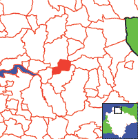
Click on map to view parish boundaries in detail.
Hide
Hide
hide
- History
- Jewish History◬
- Land & Property◬
- Language & Languages◬
- Manors◬
- Maps
- Medical Records◬
- Merchant Marine◬
- Military History◬
- Names, Geographical◬
- Names, Personal
- Newspapers◬
- Occupations◬
- Periodicals◬
- Politics & Government◬
- Poor Houses, Poor Law◬
- Population◬
- Probate Records◬
- Schools◬
- Social Life & Customs◬
- Societies◬
- Taxation◬
- Voting Registers◬
Hide
"GOODLEIGH, a small village, nearly 3 miles E. by N. of Barnstaple, has in its parish 335 souls, and 1180 acres of land, including Northleigh hamlet and several scattered houses. The manor belongs to the Misses Incledon, whose family mansion, called Yeotown, is now a farm house, and was new fronted in the Gothic style by the late B. N. Incledon, Esq. This house is in the sequestered woody valley of the small river Yeo. Miss Budd and several other proprietors have estates in this parish, which is celebrated for its cherry orchards. The Church (St. Gregory,) is an ancient Gothic structure, with a short tower, and some stained glass in its windows. Its screen is richly ornamented." [From White's Devonshire Directory (1850)]
A parish in Braunton Hundred, the Archdeaconry of Barnstaple, and the Diocese of Exeter.
Hide
MIs for this parish are included in the Incledon index - see under Cemeteries on the main Devon page.
Snetzler, M.F. North Devon Surname Index to the Census. Microfiche: M.F. Snetzler. [Covers 1881 census records for this parish]
Parish Registers going back to 1717 are held in the Devon Record Office.
Transcripts of the Parish Registers going back to 1538 are held in a special collection in the Westcountry Studies Library.
The Devon FHS publishes indexes covering (as of June 2004): Marriages 1754-1837, Burials 1813-1837 - for details see their Devon Parish List.
Nothing transcribed into the IGI (as of Jan 1993).
An index of baptisms, marriages and burials in the parishes of Arlington, Ashford, Berrynarbor, Bittadon, Bratton Fleming, Braunton, Brendon, Challacombe, Charles, Combe Martin, Countisbury, East Buckland, East Down, Georgeham, Goodleigh, Heanton Punchardon, High Bray, Ilfracombe, Kentisbury, Loxhore, Lynton, Martinhoe, Marwood, Mortehoe, Parracombe, Shirwell, Stoke Rivers, Trentishoe, West Buckland and West Down. With photographs of the churches and extracts from White's Directory (1850) and Kelly's Directory of Devonshire (1902), CD-ROM, Exeter, Devon FHS (2015). [Arlington Bapt: 1813-1839, Mar: 1755-1836, Bur: 1814-1837; Ashford Bapt: 1813-1840, Mar: 1747-1837, Bur: 1813-1837; Berrynarbor Bapt: 1813-1839, Mar: 1755-1837, Bur: 1813-1837; Bittadon Bapt: 1813-1843, Mar: 1754-1835, Bur: 1815-1843; Bratton Fleming Bapt: 1813-1840, Mar: 1754-1837, Bur: 1800-1837; Braunton Bapt: 1813-1839, Mar: 1754-1837, Bur: 1813-1837; Brendon Bapt: 1813-1839, Mar: 1754-1837, Bur: 1813-1837; Challacombe Bapt: 1813-1840, Mar: 1754-1837, Bur: 1822-1848; Charles Bapt: 1813-1839, Mar: 1754-1837, Bur: 1813-1837; Combe Martin Bapt: 1813-1840, Mar: 1754-1837, Bur: 1813-1837; Countisbury Bapt: 1813-1839, Mar: 1755-1837, Bur: 1813-1837; East Buckland Bapt: 1813-1838, Mar: 1755-1836, Bur: 1813-1839; East Down Bapt: 1813-1839, Mar: 1754-1839, Bur: 1813-1852; Georgeham Bapt: 1813-1839, Mar: 1754-1837, Bur: 1813-1837; Goodleigh Bapt: 1813-1839, Mar: 1754-1837, Bur: 1813-1837; Heanton Punchardon Bapt: 1813-1839, Mar: 1754-1837, Bur: 1800-1837; High Bray Bapt: 1813-1839, Mar: 1756-1837, Bur: 1813-1837; Ilfracombe Bapt: 1813-1840, Mar: 1754-1837, Bur: 1813-1837; Kentisbury Bapt: 1813-1839, Mar: 1754-1841, Bur: 1813-1837; Loxhore Bapt: 1813-1839, Mar: 1754-1837, Bur: 1813-1837; Lynton Bapt: 1813-1839, Mar: 1754-1837, Bur: 1813-1838; Martinhoe Bapt: 1813-1839, Mar: 1754-1837, Bur: 1813-1839; Marwood Bapt: 1813-1839, Mar: 1754-1837, Bur: 1813-1837; Mortehoe Bapt: 1813-1840, Mar: 1754-1837, Bur: 1750-1837; Parracombe Bapt: 1813-1839, Mar: 1598-1838, Bur: 1813-1838; Shirwell Bapt: 1813-1840, Mar: 1754-1837, Bur: 1813-1837; Stoke Rivers Bapt: 1813-1839, Mar: 1754-1837, Bur: 1813-1839; Trentishoe Bapt: 1813-1839, Mar: 1754-1837, Bur: 1813-1837; West Buckland Bapt: 1813-1840, Mar: 1754-1837, Bur: 1813-1851; West Down Bapt: 1813-1840, Mar: 1754-1837, Bur: 1813-1840.]
Section on Goodleigh from Samuel Lewis: A Topographical Dictionary of England (1831), provided by Mel Lockie.
Transcript of complete entry in White's Devonshire Directory of 1850.
Transcription, by Jonathan Frayne of the Goodleigh section of Kelly's Directory of Barnstaple and Neighbourhood (1941).
The transcription of the section for this parish from the National Gazetteer (1868), provided by Colin Hinson.
- Ask for a calculation of the distance from Goodleigh to another place.
Fice, John. The Goodleigh Militia and the Pasmore Family, Family Tree Magazine, vol. 4, no. 11 pp.32-33 and 12, pp.15-16 (1988). ["This article concentrates on one North Devon village in 1598 and the people who lived in it at the time of a turning point in history - the defeat of the Spanish Armada. The activities of the local defence force are highlighted together with the sixteenth century history of one leading family in the village community."]
Fice, J. E. The History of Goodleigh: a North Devon village. Goodleigh: Fice, Toptown Printers (1982), 128 pp. ill., maps.
View a map of the boundaries of this town/parish.
You can see maps centred on OS grid reference SS598341 (Lat/Lon: 51.08903, -4.003254), Goodleigh which are provided by:
- OpenStreetMap
- Google Maps
- StreetMap (Current Ordnance Survey maps)
- Bing (was Multimap)
- Old Maps Online
- National Library of Scotland (Old Ordnance Survey maps)
- Vision of Britain (Click "Historical units & statistics" for administrative areas.)
- English Jurisdictions in 1851 (Unfortunately the LDS have removed the facility to enable us to specify a starting location, you will need to search yourself on their map.)
- Magic (Geographic information) (Click + on map if it doesn't show)
- GeoHack (Links to on-line maps and location specific services.)
- All places within the same township/parish shown on an Openstreetmap map.
- Nearby townships/parishes shown on an Openstreetmap map.
- Nearby places shown on an Openstreetmap map.
Goodleigh contributors to a 1678 brief for the rebuilding of St Paul's Cathedral.