
Hide
--- TEST SYSTEM --- TEST SYSTEM --- TEST SYSTEM ---
Hide
Dartmouth Townstall
hide
Hide
hide
- Almanacs△
- Archives & Libraries◬
- Bibliography△
- Biography◬
- Business & Commerce Records△
- Cemeteries
- Census
- Chronology△
- Church History
- Church Records
- Civil Registration△
- Correctional Institutions△
- Court Records◬
- Description & Travel
- Directories◬
- Emigration & Immigration◬
- Encyclopaedias & Dictionaries△
- Folklore◬
- Gazetteers
- Genealogy◬
- Handwriting△
- Heraldry◬
- Historical Geography△
- History◬
Hide
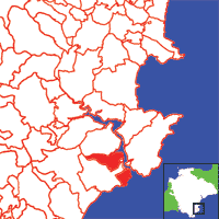
Click on map to view parish boundaries in detail.
Hide
Hide
hide
- Jewish History△
- Land & Property◬
- Language & Languages△
- Manors△
- Maps
- Medical Records△
- Merchant Marine◬
- Military History◬
- Military Records◬
- Names, Geographical△
- Names, Personal◬
- Newspapers◬
- Occupations◬
- Periodicals△
- Politics & Government◬
- Poor Houses, Poor Law△
- Population△
- Probate Records◬
- Public Records◬
- Schools△
- Social Life & Customs△
- Societies◬
- Taxation◬
- Voting Registers△
Hide
"TOWNSTAL extends north-west beyond the borough, and comprises the hamlets of Norton, 0ldmill, Ford, and Warfleet, and 1688A. 3R. 34p. of land, mostly the property of Sir Henry Paul Seale, Bart., lord of the manors of Townstal and Norton-Dawney; who has a large castellated mansion here, called Mount Boon, situated on a commanding eminence, west of the town, and formerly a seat of the Boone and Harris families, the latter of whom sold the estate to the Seales about 1700. . . . Townstal Church (St. Clement,) on a bold eminence about half a mile north of the town, is an ancient structure, of early English. architecture, with a lofty tower, containing four bells. The interior has several neat mural tablets, and the living is a vicarage, valued in 1831 at £135, with the curacy of St. Saviour's annexed to it in the patronage of Sir H. P. Seale, and incumbency of the Rev. John Tracey, B.A., who has a good residence, and two yearly stipends, viz., £105 out of the tithes of Sherford, and about £18 out of the tithes of Townstal parish, which were commuted in 1840 for £294. 17s. 6d. per annum. The latter formerly belonged to Tor Abbey, but have been in the impropriation of the corporation of Dartmouth since the Reformation; and they had also the advowson till they sold it a few years ago." [From White's Devonshire Directory (1850)]
A parish within the seaport, market town and borough of Dartmouth, in Coleridge Hundred, the Archdeaconry of Totnes and the Diocese of Exeter, that had 1014 inhabitants in 1801. Includes Hardness.
Hide
Longcross Cemetery burial records from the Find A Grave website.
Transcript of burials at St Clements Church, Townstall, from the Dartnouth History Society.
Whitmore, J.B. Devonshire Monumental Inscriptions, MS at Society of Genealogists (1951). [Extracts]
Transcript of the 1841 Census, from the Parishes of the South Hams website.
Townstall - from J. Stabb. Some Old Devon Churches (London: 1908-16).
Watkin, hugh R. The Lost Chapel of Saint Clare at Hardness, Dartmouth. Trans. Devon Assoc. 61 (1929) pp.219-232. [Raymond: Includes extracts from 36 deeds, 1253-1456.]
Parish Registers going back to 1653 are held in the Devon Record Office.
Transcripts of the Parish Registers going back to 1653, and of the Bishops' Transcripts going back to 1597, are held in a special collection in the Westcountry Studies Library.
The Devon FHS publishes indexes covering (as of June 2004): Marriages 1754-1837, Burials 1813-1837 - for details see their Devon Parish List.
Transcripts of Marriages 1597 - 1786 and Burials at St Clements Church, Townstall are available on the Dartmouth Archives website.
Entered into the IGI (as of Jan 1993): Parish Church Christenings 1597-1837, Marriages 1597-1633, 1653-1837.
McNaught, M.J. Marriage Registers of the Deanery of Totnes, Devon, Vol.2: Dartmouth (St Clement or Townstall) M 1597-1850, strays index; Dartmouth (St Petrox) M1610-1850, strays index; Dartmouth (St Saviours) M1586-1850, strays index, (2006). [SoG Library DE/R 99] [Transcripts are available on the Dartmouth Archives web-site.]
The Deanery of Totnes: An index of baptisms, marriages and burials . . . with photographs of the churches and extracts from White's Devonshire Directory 1850, CD-ROM, Exeter, Devon FHS (2009). [Ashprington: Bapt (1813-1839), Mar (1754-1837), Bur (1813-1837), Blackawton: Bapt (1813-1839), Mar (1754-1837), Bur (1813-1837), Buckfastleigh: Bapt (1813-1839), Mar (1754-1837), Bur (1813-1837), Cornworthy: Bapt (1813-1839), Mar (1754-1837), Bur (1813-1840), Dartington: Bapt (1813-1839), Mar (1754-1837), Bur (1813-1837), Dartmouth St. Clement: Bapt (1813-1839), Mar (1754-1837), Bur (1813-1837), Dartmouth St. Petrox: Bapt (1813-1839), Mar (1754-1837), Bur (1813-1837), Dartmouth St. Saviour: Bapt (1813-1839), Mar (1754-1837), Bur (1813-1837), Dean Prior: Bapt (1813-1839), Mar (1755-1837), Bur (1790-1837), Diptford: Bapt (1813-1839), Mar (1754-1837), Bur (1813-1837), Dittisham: Bapt (1813-1839), Mar (1754-1837), Bur (1813-1837), Halwell: Bapt (1813-1839), Mar (1755-1837), Bur (1813-1837), Harberton: Bapt (1813-1839), Mar (1754-1837), Bur (1813-1837), Holne: Bapt (1813-1842), Mar (1754-1837), Bur (1813-1837), Rattery: Bapt (1813-1839), Mar (1754-1837), Bur (1800-1837), South Brent: Bapt (1813-1839), Mar (1754-1837), Bur (1813-1837), Stoke Fleming: Bapt (1813-1839), Mar (1754-1837), Bur (1813-1837), Totnes: Bapt (1813-1842), Mar (1754-1837), Bur: (1813-1837)]
Transcripts of Dartmouth Townstall (St Clement) parish registers and Bishop's transcripts, 1597-1837, LDS Film 0917194.
The transcription of the section for this parish from the National Gazetteer (1868), provided by Colin Hinson.
- Ask for a calculation of the distance from Dartmouth Townstall to another place.
View a map of the boundaries of this town/parish.
You can see maps centred on OS grid reference SX869514 (Lat/Lon: 50.351618, -3.591099), Dartmouth Townstall which are provided by:
- OpenStreetMap
- Google Maps
- StreetMap (Current Ordnance Survey maps)
- Bing (was Multimap)
- Old Maps Online
- National Library of Scotland (Old Ordnance Survey maps)
- Vision of Britain (Click "Historical units & statistics" for administrative areas.)
- English Jurisdictions in 1851 (Unfortunately the LDS have removed the facility to enable us to specify a starting location, you will need to search yourself on their map.)
- Magic (Geographic information) (Click + on map if it doesn't show)
- GeoHack (Links to on-line maps and location specific services.)
- All places within the same township/parish shown on an Openstreetmap map.
- Nearby townships/parishes shown on an Openstreetmap map.
- Nearby places shown on an Openstreetmap map.