
Hide
--- TEST SYSTEM --- TEST SYSTEM --- TEST SYSTEM ---
Hide
Creacombe
hide
Hide
hide
- Almanacs◬
- Archives & Libraries◬
- Bibliography◬
- Biography◬
- Business & Commerce Records◬
- Cemeteries
- Census
- Chronology◬
- Church History◬
- Church Records
- Churches
- Civil Registration◬
- Correctional Institutions◬
- Court Records◬
- Description & Travel
- Directories◬
- Emigration & Immigration◬
- Encyclopaedias & Dictionaries◬
- Folklore◬
- Gazetteers
- Genealogy◬
- Handwriting◬
- Heraldry◬
- Historical Geography◬
Hide
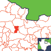
Click on map to view parish boundaries in detail.
Hide
Hide
hide
- History◬
- Jewish History◬
- Land & Property
- Language & Languages◬
- Manors◬
- Maps
- Medical Records◬
- Merchant Marine◬
- Military History◬
- Names, Geographical◬
- Names, Personal◬
- Newspapers◬
- Occupations◬
- Periodicals◬
- Politics & Government◬
- Poor Houses, Poor Law◬
- Population◬
- Probate Records◬
- Schools◬
- Social Life & Customs◬
- Societies◬
- Taxation◬
- Voting Registers◬
Hide
"CREACOMBE is a small parish, on the river Sturcombe, 6 miles south-west from East Anstey station on the Somerset and Devon branch of the Great Western railway, 10 miles north-north-west from Tiverton, and 10 south-west from Bampton, in the Northern division of the county, Witheridge hundred, South Molton petty sessional division, union and county court district, rural deanery of South Molton, archdeaconry of Barnstaple and diocese of Exeter. The church of St. Michael, rebuilt in 1857 by Mrs. Karslake, mother of the late rector, is a small edifice in the Early English style. . . The register of baptisms and burials dates from the year 1695; marriages, 1759. The living is a rectory, net yearly value £175, including 311 acres of glebe, in the gift of Sir W. W. Karslake, and held since 1896 by the Rev. Alexander Frederick De Gex, who is also rector of and resides at Meshaw. Sir W. W. Karslake of 8 Curzon street, London W. is lord of the manor. The Hon. Mark George Kerr Rolle, J. Quicke esq. and the Rev. John Peter Benson M.A. vicar of Witheridge, and Mr. L. Davies are the landowners. The soil is good, but clayey; subsoil, clay and shillet. The chief crops are barley and oats. . . The children of this place attend the school at Rackenford." [From: Kelly's Directory of Devonshire, 1902]
A parish in Witheridge Hundred, the Archdeaconry of Barnstaple, and the Diocese of Exeter.
Hide
MIs for this parish are included in the Devon FHS, Incledon and NDA North Devon indexes - see under Cemeteries on the main Devon page.
A transcription of the Memorial Inscriptions for the Parish Church is held in the Society of Genealogist's Library, in Vol. 8 of Devon Memorial inscriptions (DE/M23).
Snetzler, M.F. North Devon Surname Index to the Census. Microfiche: M.F. Snetzler. [Covers 1841, 1861, 1871 and 1881 census records for this parish]
Parish Registers going back to 1695 are held in the Devon Record Office.
Transcripts of the Parish Registers going back to 1694 are held in a special collection in the Westcountry Studies Library.
The Devon FHS publishes indexes covering (as of June 2004): Marriages 1754-1837 - for details see their Devon Parish List.
Entered into the IGI (as of Jan 1993): Parish Church Christenings 1704-1837.
Creacombe Parish register transcripts, Baptisms 1694-1837, Marriages 1759-1835, LDS Film 0917181/4.
The Deanery of South Molton: An index of baptisms, marriages and burials in the parishes of Bishop's Nympton, Cheldon, Creacombe, Cruwys Morchard, East Anstey, East Woolfardisworthy, East Worlington, George Nympton, King's Nympton, Knowstone, Mariansleigh, Meshaw, Molland, North Molton, Oakford, Puddington, Rackenford, Romansleigh, Rose Ash, Satterleigh, South Molton, Stoodleigh, Templeton, Thelbridge, Twitchen, Warkleigh, Washford Pyne, West Anstey, West Worlington and Witheridge. With photographs of the churches and extracts from White's Directory (1850) and Kelly's Directory of Devonshire (1902). CD-ROM 062, Exeter, Devon FHS (2015). [Bishop's Nympton Bapt: 1813-1839, Mar: 1754-1837, Bur: 1813-1837; Cheldon Bapt: 1813-1843, Mar: 1755-1835, Bur: 1813-1841; Creacombe Bapt: 1814-1902, Mar: 1759-1835, Bur: 1813-1850; Cruwys Morchard Bapt: 1813-1840, Mar: 1754-1837, Bur: 1813-1837; East Anstey Bapt: 1813-1840, Mar: 1754-1836, Bur: 1688-1839; East Woolfardisworthy Bapt: 1813-1840, Mar: 1754-1840, Bur: 1813-1837; East Worlington Bapt: 1813-1840, Mar: 1754-1837, Bur: 1813-1837; George Nympton Bapt: 1813-1840, Mar: 1755-1837, Bur: 1790-1837; King's Nympton Bapt: 1813-1840, Mar: 1754-1837, Bur: 1813-1837; Knowstone Bapt: 1813-1840, Mar: 1740-1836, Bur: 1813-1837; Mariansleigh Bapt: 1813-1839, Mar: 1757-1837, Bur: 1813-1838; Meshaw Bapt: 1813-1839, Mar: 1756-1836, Bur: 1813-1838; Molland Bapt: 1813-1840, Mar: 1754-1837, Bur: 1813-1838; North Molton Bapt: 1813-1839, Mar: 1754-1837, Bur: 1813-1837; Oakford Bapt: 1813-1839, Mar: 1754-1837, Bur: 1813-1840; Puddington Bapt: 1813-1839, Mar: 1759-1836, Bur: 1740-1837; Rackenford Bapt: 1813-1840, Mar: 1754-1837, Bur: 1800-1837; Romansleigh Bapt: 1813-1839, Mar: 1754-1836, Bur: 1730-1837; Rose Ash Bapt: 1813-1839, Mar: 1754-1837, Bur: 1813-1850; Satterleigh Bapt: 1813-1839, Mar: 1755-1836, Bur: 1813-1837; South Molton Bapt: 1813-1840, Mar: 1754-1837, Bur: 1813-1837; Stoodleigh Bapt: 1813-1840, Mar: 1754-1837, Bur: 1813-1837; Templeton Bapt: 1813-1840, Mar: 1754-1837, Bur: 1813-1837; Thelbridge Bapt: 1813-1839, Mar: 1754-1837, Bur: 1813-1853; Twitchen Bapt: 1813-1839, Mar: 1755-1836, Bur: 1813-1837; Warkleigh Bapt: 1813-1839, Mar: 1754-1837, Bur: 1813-1851; Washford Pyne Bapt: 1813-1840, Mar: 1756-1836, Bur: 1813-1840; West Anstey Bapt: 1813-1840, Mar: 1754-1836, Bur: 1745-1838; West Worlington Bapt: 1813-1840, Mar: 1754-1846, Bur: 1813-1851; Witheridge Bapt: 1813-1839, Mar: 1754-1837, Bur: 1813-1835]
Section on Creacombe from Samuel Lewis: A Topographical Dictionary of England (1831), provided by Mel Lockie.
The transcription of the section for this parish from the National Gazetteer (1868), provided by Colin Hinson.
- Ask for a calculation of the distance from Creacombe to another place.
Land tax assessment for Creacombe, 1780-1832, LDS Film 1471060/8.
Land tax assessment for Creacombe, 1798, LDS Film 1526151/23.
View a map of the boundaries of this town/parish.
You can see maps centred on OS grid reference SS818193 (Lat/Lon: 50.960964, -3.684452), Creacombe which are provided by:
- OpenStreetMap
- Google Maps
- StreetMap (Current Ordnance Survey maps)
- Bing (was Multimap)
- Old Maps Online
- National Library of Scotland (Old Ordnance Survey maps)
- Vision of Britain (Click "Historical units & statistics" for administrative areas.)
- English Jurisdictions in 1851 (Unfortunately the LDS have removed the facility to enable us to specify a starting location, you will need to search yourself on their map.)
- Magic (Geographic information) (Click + on map if it doesn't show)
- GeoHack (Links to on-line maps and location specific services.)
- All places within the same township/parish shown on an Openstreetmap map.
- Nearby townships/parishes shown on an Openstreetmap map.
- Nearby places shown on an Openstreetmap map.