Hide
--- TEST SYSTEM --- TEST SYSTEM --- TEST SYSTEM ---
Hide
Broad Nymet
hide
Hide
hide
- Almanacs◬
- Archives & Libraries◬
- Bibliography◬
- Biography◬
- Business & Commerce Records◬
- Cemeteries◬
- Census◬
- Chronology◬
- Church History◬
- Church Records
- Civil Registration◬
- Correctional Institutions◬
- Court Records◬
- Description & Travel
- Directories◬
- Emigration & Immigration◬
- Encyclopaedias & Dictionaries◬
- Folklore◬
- Gazetteers
- Genealogy◬
- Handwriting◬
- Heraldry◬
- Historical Geography◬
Hide
hide
- History
- Jewish History◬
- Land & Property◬
- Language & Languages◬
- Manors◬
- Maps
- Medical Records◬
- Merchant Marine◬
- Military History◬
- Names, Geographical◬
- Names, Personal◬
- Newspapers◬
- Occupations◬
- Periodicals◬
- Politics & Government◬
- Poor Houses, Poor Law◬
- Population◬
- Probate Records◬
- Schools◬
- Social Life & Customs◬
- Societies◬
- Taxation◬
- Voting Registers◬
Hide
"NYMET, (BROAD) on one of the tributary streams of the river Taw, 8 ½ miles W. of Crediton, is a small parish, which contains only 50 inhabitants, and 451 acres of land; and until lately, it claimed exemption from county and highway rates, but a recent decision in the Court of the Exchequer declared it liable to both. It pays church and poor rates, &c., to North Tawton, its small antique church having long been used as a lumber room. Its sinecure rectory, valued in K.B. at £2. 4s. 2d., and in 1821 at £48, is in the same patronage and incumbency as Bow, or Nymet-Tracey. The manor anciently belonged to the family of De Brode Nymet, and is now nearly all one farm, belonging to Mr. Rd. Dunning, and occupied by Thos. Prickman." [From White's Devonshire Directory (1850)]
Hide
Peskett: There are no registers. (Both Bow and North Tawton registers include entries for Broad Nymet.)
Section on Broad Nymet from Samuel Lewis: A Topographical Dictionary of England (1831), provided by Mel Lockie.
The transcription of the section for this parish from the National Gazetteer (1868), provided by Colin Hinson.
- Ask for a calculation of the distance from Broad Nymet to another place.
Carbonnell, Barbara M.H. and Wauton, M. Thirteen Centuries in Bow alias Nymet Tracey with Broadnymet, James townsend (1949) 57p., plates : ill,map. [DFHS Library]
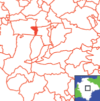
View a map of the boundaries of this town/parish.
You can see maps centred on OS grid reference SS702009 (Lat/Lon: 50.79309, -3.843002), Broad Nymet which are provided by:
- OpenStreetMap
- Google Maps
- StreetMap (Current Ordnance Survey maps)
- Bing (was Multimap)
- Old Maps Online
- National Library of Scotland (Old Ordnance Survey maps)
- Vision of Britain (Click "Historical units & statistics" for administrative areas.)
- English Jurisdictions in 1851 (Unfortunately the LDS have removed the facility to enable us to specify a starting location, you will need to search yourself on their map.)
- Magic (Geographic information) (Click + on map if it doesn't show)
- GeoHack (Links to on-line maps and location specific services.)
- All places within the same township/parish shown on an Openstreetmap map.
- Nearby townships/parishes shown on an Openstreetmap map.
- Nearby places shown on an Openstreetmap map.

